Related Research Articles

Greater Wellington, also known as the Wellington Region, is a non-unitary region of New Zealand that occupies the southernmost part of the North Island. The region covers an area of 8,049 square kilometres (3,108 sq mi), and has a population of 543,500.
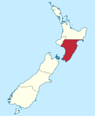
Wellington Province, governed by the Wellington Provincial Council, was one of the provinces of New Zealand from 1853 until the abolition of provincial government in 1876. It covered much of the southern half of the North Island until November 1858, when Hawke's Bay Province split off, taking about a third of its area.

Atka Island is the largest island in the Andreanof Islands of the Aleutian Islands of Alaska. The island is 50 miles (80 km) east of Adak Island. It is 65 miles (105 km) long and 2–20 miles (3–30 km) wide with a land area of 404.6 square miles (1,048 km2), making it the 22nd largest island in the United States. The northeast of Atka Island contains the Korovin volcano which reaches a peak of 5,030 feet (1,533 m). Oglodak Island is located 3.4 miles off Cape Kigun, Atka's westernmost point.

Orewa is a suburb of Auckland, New Zealand’s largest city. It lies on the Hibiscus Coast, just north of the base of the Whangaparāoa Peninsula and 40 kilometres north of central Auckland. It is a popular holiday destination.

Newlands is one of the northern suburbs of Wellington, New Zealand. It lies approximately 8.1 km north of the city centre and to the east of its nearest neighbour Johnsonville. It has a long history of early settlement and originally was farmed including being the early source of Wellington's milk. Newlands is located in a valley and covers two ridgelines, the side of one of which overlooks Wellington Harbour and up to the Hutt Valley.

Wilton is a small suburb in Wellington. It is best known for Otari-Wilton's Bush, a large reserve that is situated in the suburb. Otari-Wilton's bush is the only public botanic garden in New Zealand dedicated solely to native plants. It features 14 km of walking tracks and a 'canopy walkway'. The canopy walkway is a raised walkway that provides a unique chance to view life in, and from, the top level of trees such as mature tawa, rewarewa and hinau.
Horahora is a suburb on the southwestern side of Whangārei, in Northland, New Zealand.
Onepoto is a locality of Porirua City in New Zealand. It is bounded to the north by Whitireia Park, a large park which is slowly being returned to native bush, and to the east by the Porirua Harbour.

Halfway Bush is a suburb of the New Zealand city of Dunedin. It is located 3 kilometres (1.9 mi) to the northwest of the city centre, close to the point at which Taieri Road becomes the winding rural Three Mile Hill Road. It was this road which gave the suburb its name, as this locality was halfway between the Taieri Plains and central Dunedin in the early days of European settlement, when Three Mile Hill was the main route from Dunedin to the Otago hinterland. This route was superseded by the route through the Caversham Valley in the 1860s.
Glendale is a suburb of Wainuiomata, part of Lower Hutt city situated in the lower North Island of New Zealand.
The Hikurangi River is a river of Northland, New Zealand. A winding stretch of river, it can be considered an extension of the Kaikou River, being formed from the confluence of this river and the Moengawahine Stream. The Hikurangi flows south past the Pipiwai settlement for several kilometres before flowing into the Mangakahia River, 25 kilometres (16 mi) west of Whangarei.
Keys Hill is a hill about 1,100 metres (3,600 ft) high located at the head of Shearwater Glacier, 2.2 nautical miles (4 km) west-southwest of the summit of Mount Bird in northwestern Ross Island, Antarctica. It was named by the New Zealand Geographic Board in 2000 after Gordon Keys, a leader of long term New Zealand Antarctic Programme atmospheric research, 1985–95.
Springs Flat is a suburb to the north of Whangārei in Northland, New Zealand.

Kennedys Bush is a south-western suburb of Christchurch, New Zealand.

The Counties Manukau District Health Board was a district health board which focused on providing healthcare to the Counties Manukau area in southern Auckland, New Zealand. As of 2016, it ws responsible for 534,750 residents; or 11% of New Zealand's population. In July 2022, CM Health was merged into the national health service Te Whatu Ora.
Woodridge is one of the northern suburbs of Wellington, New Zealand, north of Newlands and Paparangi.

The Waitemata District Health Board was a district health board that provided healthcare to people living in the area that used to be covered by North Shore city, Rodney District, and Waitakere City in New Zealand. It was abolished on July 1st 2022 and replaced with Te Whatu Ora.
Lower Moutere is a settlement in the Tasman District of New Zealand's upper South Island. It is a farming community it the Lower Moutere valley, 6 km (3.7 mi) from Motueka closed to the Moutere Inlet.

Hobson Street is the major street in Auckland, New Zealand. It lies on the western side of Queen Street. It is a commercial and high-rise residential street, and provides access to the Auckland Northern Motorway going south, and the Northwest Motorway going west. For most of its length it is one-way. One block to the west is Nelson Street, which is one-way in the other direction and provides access to the central city for traffic exiting from the motorways. One block to the east is Albert Street, part of Mayoral Drive, and Vincent Street. The area encompassed by these streets is called Hobson Ridge by Statistics New Zealand.
The Strand is a street in Auckland, New Zealand's most populous city. It connects the Ports of Auckland to the Auckland motorway network, and is the eastern end of State Highway 16.
References
- ↑ Roger Smith, GeographX (2005). The Geographic Atlas of New Zealand. Robbie Burton. pp. map 24. ISBN 1-877333-20-4.
- ↑ 2013 Census QuickStats about a place : Three Mile Bush
Coordinates: 35°41′S174°17′E / 35.683°S 174.283°E
| | This Northland Region-related geography article is a stub. You can help Wikipedia by expanding it. |