Ngunguru

Last updated • 4 min readFrom Wikipedia, The Free Encyclopedia

Ngunguru
Ngunguru.jpg
Ngunguru coast
Ngunguru
Coordinates: 35°38′04″S174°30′00″E / 35.63444°S 174.50000°E / -35.63444; 174.50000
CountryNew Zealand
Region Northland Region
District Whangarei District
WardWhangarei Heads Ward
Electorates
Government
  Territorial Authority Whangarei District Council
  Regional council Northland Regional Council
   Mayor of Whangārei Vince Cocurullo
   Whangārei MP Shane Reti
   Te Tai Tokerau MP Mariameno Kapa-Kingi
Area
[1]
  Total
3.57 km2 (1.38 sq mi)
Population
 (June 2024) [2]
  Total
1,240
  Density350/km2 (900/sq mi)

Ngunguru is a coastal settlement in Northland, New Zealand, 26 kilometres (16 mi) north-east of Whangārei. The Ngunguru River flows between the settlement and a long low sandspit into Ngunguru Bay, which stretches southwards. North of Ngunguru are Tutukaka and Matapouri. Just off the Ngunguru coast are the Poor Knights Islands, a protected marine reserve. [3] [4]

Contents

Ngunguru is a Māori-language word meaning "rumbling tides". [5]

History

The waka Tūnui-ā-rangi, which brought Ngāi Tāhuhu to New Zealand according to traditional accounts, visited Ngunguru on its way from the Bay of Islands to Whangarei. [6] The area was named by Puhi, captain of another waka, Mataatua. [7]

In pre-European times, there was a substantial Māori population in the area. [8] A large battle was fought on the Ngunguru sandspit between the local Te Waiariki and Waikato tribes led by Te Wherowhero in 1832. [9]

The first chart of "Nongodo" was drawn by Captain N. C. Phillips of HMS Buffalo in 1836. [8] James Busby, Gilbert Mair and W. J. Lewington bought 40,000 acres (16,000 ha) at Ngunguru in 1840, although the government disputed the sale for the next 30 years and attempted to buy the land itself from the original Māori owners. [10] [11] They established one of the earliest sawmills in the country at Ngunguru in 1840 to take advantage of the abundant kauri timber. It was water-powered. [12] The mill failed financially in 1844, [13] but others succeeded in the industry and Ngunguru exported timber and especially roofing shingles for many years. [8]

The Melanesian Mission ship Southern Cross was wrecked in Ngunguru Bay in 1860. [8] [14]

A bullock track was built to Whangarei in the 1860s. [15] In 1892, coal was discovered at Kiripaka, at the headwaters of the Ngunguru River. 620,000 long tons (630,000 t) were mined until 1921. [8]

The beach settlement developed after roading was improved in the 1950s. [16] An attempt to sell the Ngunguru sandspit for property development in 2005 attracted considerable local opposition, and no buyers. [17] In August 2011 the government purchased the spit from the Todd Property Group. The Department of Conservation will administer the reserve, which is one of a small number of sand spits that are relatively intact from an ecological perspective. Four separate assessments have ranked the spit as nationally significant [18]

In October 2022 the Scotland women's national rugby team visited Ngunguru Marae in what was called a celebration of "the genealogical links between Scotland and Māori" by Te Ao Māori News. [19] [20]

Demographics

Ngunguru covers 3.57 km2 (1.38 sq mi) [1] and had an estimated population of 1,240 as of June 2024, [2] with a population density of 347 people per km2.

Historical population
YearPop.±% p.a.
2006879    
2013918+0.62%
20181,164+4.86%
20231,173+0.15%
Source: [21] [22]

Ngunguru had a population of 1,173 in the 2023 New Zealand census, an increase of 9 people (0.8%) since the 2018 census, and an increase of 255 people (27.8%) since the 2013 census. There were 582 males, 588 females and 3 people of other genders in 450 dwellings. [23] 2.0% of people identified as LGBTIQ+. The median age was 46.3 years (compared with 38.1 years nationally). There were 222 people (18.9%) aged under 15 years, 147 (12.5%) aged 15 to 29, 516 (44.0%) aged 30 to 64, and 291 (24.8%) aged 65 or older. [22]

People could identify as more than one ethnicity. The results were 88.0% European (Pākehā); 20.7% Māori; 2.6% Pasifika; 2.8% Asian; 1.5% Middle Eastern, Latin American and African New Zealanders (MELAA); and 2.6% other, which includes people giving their ethnicity as "New Zealander". English was spoken by 98.5%, Māori language by 4.9%, and other languages by 8.4%. No language could be spoken by 1.3% (e.g. too young to talk). New Zealand Sign Language was known by 0.3%. The percentage of people born overseas was 21.7, compared with 28.8% nationally.

Religious affiliations were 22.3% Christian, 0.8% Hindu, 0.3% Islam, 0.5% Māori religious beliefs, 0.3% Buddhist, 0.5% New Age, 1.3% Jewish, and 1.5% other religions. People who answered that they had no religion were 65.7%, and 7.4% of people did not answer the census question.

Of those at least 15 years old, 210 (22.1%) people had a bachelor's or higher degree, 492 (51.7%) had a post-high school certificate or diploma, and 177 (18.6%) people exclusively held high school qualifications. The median income was $39,500, compared with $41,500 nationally. 105 people (11.0%) earned over $100,000 compared to 12.1% nationally. The employment status of those at least 15 was that 414 (43.5%) people were employed full-time, 162 (17.0%) were part-time, and 21 (2.2%) were unemployed. [22]

Facilities

Ngunguru School is a coeducational full primary (years 1–8) school with a roll of 224 students as of November 2024. [24] [25] The school celebrated its centennial in 1970. [26]

Ngunguru has a sports and recreation club, which started in the late 1970s in a leased farm paddock. Then in 1979 the first club committee took over the land lease and started building up the club's facilities. The sports ground was officially opened on 20 March 1982 with a gala and a rugby match "between the Northland Vikings (a virtual Northland side) and a star-studded Ngunguru Invitation side which included three former All Blacks". [27]

Related Research Articles

<span class="mw-page-title-main">Kaipara District</span> Territorial authority district in Northland, New Zealand

Kaipara District is a territorial authority district in the Northland Region of New Zealand.

<span class="mw-page-title-main">Thames-Coromandel District</span> Territorial authority district in Waikato, New Zealand

The Thames-Coromandel District is a territorial authority district in the North Island of New Zealand, covering all the Coromandel Peninsula and extending south to Hikutaia.

Tangiteroria is a small rural community in the North Island of New Zealand. It is located halfway between Whangārei and Dargaville on State Highway 14 on the banks of the Northern Wairoa river.

<span class="mw-page-title-main">Far North District</span> Territorial authority district in Northland Region, New Zealand

The Far North District is the northernmost territorial authority district of New Zealand, consisting of the northern part of the Northland Peninsula in the North Island. It stretches from North Cape / Otou and Cape Reinga / Te Rerenga Wairua in the north, down to the Bay of Islands, the Hokianga and the town of Kaikohe.

Kamo is a northern suburb of the New Zealand city of Whangārei. The town's name was legally changed to Te Kamo in 2023. It is approximately five minutes' drive from the centre of Whangārei. There was coal mining in the area between 1875 and 1955, and it was known for its hot springs in the early years of the 20th century.

<span class="mw-page-title-main">Onerahi</span> Suburb in Whangārei, New Zealand

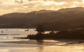
Onerahi, for half a century known as Grahamtown, is a seaside suburb of Whangārei, New Zealand's northernmost city. It is the city's only seaside suburb. It is located 9 km south-east of the centre of Whangārei and is principally a peninsula in the Whangārei Harbour, which empties into the Pacific Ocean.

Raumanga is a suburb of Whangārei in the Northland Region of New Zealand. It is the site of Northland Polytechnic's main campus.

<span class="mw-page-title-main">Tikipunga</span> Suburb in Whangārei, New Zealand

Tikipunga is one of the biggest suburbs in Whangārei, New Zealand. It is in the north-east part of the city and has the landmark Whangārei Falls nearby.

Marsden Point is a broad, flat peninsula that is the southern head of the Whangārei Harbour entrance on the east coast of Northland, New Zealand, 30 kilometres (19 mi) southeast of the city of Whangārei. It is the location of Marsden Point Oil Refinery and the Northport cargo port.

<span class="mw-page-title-main">Herekino</span> Place in Northland Region, New Zealand

Herekino is a locality in Northland, New Zealand. It lies 26 km south west of Kaitaia. The Herekino Harbour, also called the Herekino River, is an estuary and inlet from the Tasman Sea to the west. The Herekino Forest, which contains a stand of large kauri, is to the north, and the Tauroa Peninsula lies to the north west.

Panguru is a community in the northern Hokianga harbour, in Northland, New Zealand. The Whakarapa Stream flows from the Panguru Range in the Warawara Forest to the west, through Panguru and into the Hokianga.

<span class="mw-page-title-main">Whangarei District</span> Territorial authority district in Northland, New Zealand

Whangarei District is a territorial authority district in the Northland Region of New Zealand that is governed by the Whangarei District Council. The district is made up in area largely by rural land, and includes a fifth of the Northland Region. It extends southwards to the southern end of Bream Bay, northwards to Whangaruru and almost to the Bay of Islands, and westwards up the Mangakahia River valley past Pakotai and almost to Waipoua Forest. It includes the Hen and Chicken Islands and the Poor Knights Islands.

<span class="mw-page-title-main">Maungakaramea</span> Place in Northland Region, New Zealand

Maungakaramea is a locality in Northland, New Zealand. Whangārei is to the northeast.

Maungatapere is a settlement in Northland, New Zealand. State Highway 14 runs through it. Whangārei is 11 km to the east, and Tangiteroria is 18 km to the south west. The settlement takes its name from a rounded volcanic peak of the same name that lies to the southwest, and has a summit 359 metres above sea level.

Otaika is a suburb of Whangārei 7 km south of the city in Northland, New Zealand. The Otaika Stream runs from the north west, through the area, and into the Whangārei Harbour. State Highway 1 runs through the locality. The hill Tikorangi lies to the South. Tikorangi is a source of limestone for Portland Cement.

<span class="mw-page-title-main">Parua Bay</span> Place in Northland Region, New Zealand

Parua Bay is a locality and bay on the northern side of the Whangārei Harbour in Northland, New Zealand. Whangārei is 19 km to the west, and Whangārei Heads are 10 km to the south east, with Munro Bay between the two. The western head is called Manganese Point, and the eastern is Reserve Point. The Nook is a small bay just to the north of Reserve Point.

<span class="mw-page-title-main">Portland, New Zealand</span> Place in Northland Region, New Zealand

Portland is a locality on the western side of Whangārei Harbour in Northland, New Zealand. Whangārei is about 10 km to the north. Tikorangi is a hill to the west with a summit 161 m above sea level.

<span class="mw-page-title-main">Whau Valley</span> Suburb in Whangārei, New Zealand

Whau Valley is a suburb of Whangārei, in Northland Region, New Zealand. State Highway 1 runs through it. The valley was named for the whau trees which grew there in the 1850s.

<span class="mw-page-title-main">Whangārei Heads</span> Place in Northland Region, New Zealand

Whangārei Heads is a locality and volcanic promontory on the northern side of the Whangārei Harbour in Northland, New Zealand. Whangārei is 29 km (18 mi) to the north-west, and Ocean Beach is 8 km (5.0 mi) to the south-east, with Taurikura between the two. Mount Manaia rises to 420 metres to the east.

<span class="mw-page-title-main">Matapouri</span> Place in Northland Region, New Zealand

Matapouri is a coastal settlement in the Whangarei District of Northland, New Zealand. It is 7 km north of Tutukaka and 35 km north-east of Whangārei, in an area known as the Tutukaka Coast. Matapouri was described by Whangarei District Council in 2010 as "an archetypal Kiwi bach settlement". Holiday homes make up 90 per cent of the houses and at holiday times the number of residents swells to seven times its permanent population.

References

  1. 1 2 "ArcGIS Web Application". statsnz.maps.arcgis.com. Retrieved 22 April 2022.
  2. 1 2 "Aotearoa Data Explorer". Statistics New Zealand . Retrieved 26 October 2024.
  3. Peter Dowling, ed. (2004). Reed New Zealand Atlas. Reed Books. pp. map 8. ISBN   0-7900-0952-8.
  4. Roger Smith, GeographX (2005). The Geographic Atlas of New Zealand. Robbie Burton. pp. map 25. ISBN   1-877333-20-4.
  5. "Whangārei tribes". Te Ara: The Encyclopedia of New Zealand . Archived from the original on 5 April 2008.
  6. "Canoe traditions – Other northern canoes". Te Ara: The Encyclopedia of New Zealand .
  7. "Whangārei tribes – Ancestors". Te Ara: The Encyclopedia of New Zealand .
  8. 1 2 3 4 5 Parkes, W. F. (1992). Guide to Whangarei City and District. p. 37. ISBN   0-473-01639-7.
  9. "Sandspit Timeline" . Retrieved 1 April 2010.
  10. "Busby, James". Encyclopedia of New Zealand (1966) .
  11. Pickmere, Nancy Preece (1986). Whangarei: The Founding Years. p. 27.
  12. "Whangārei Harbour and north". Te Ara: The Encyclopedia of New Zealand .
  13. Pickmere, pp. 27–30
  14. "Australian and New Zealand shipwrecks".
  15. Pickmere, p. 132
  16. "Whangarei". Encyclopedia of New Zealand (1966) .
  17. Powley, Kathryn (16 July 2005). "Ngunguru Sandspit off market". The Northern Advocate.
  18. "Ngunguru Spit purchase a win for conservation". New Zealand Government (Beehive). 25 August 2011. Retrieved 25 August 2011.
  19. Ngunguru welcomes Scotland's women's rugby team | Te Ao Mārama , retrieved 24 December 2022
  20. Scotland Women’s Rugby welcomed onto Ngunguru Marae , retrieved 24 December 2022
  21. "Statistical area 1 dataset for 2018 Census". Statistics New Zealand. March 2020. Ngunguru (107600). 2018 Census place summary: Ngunguru
  22. 1 2 3 "Totals by topic for individuals, (RC, TALB, UR, SA3, SA2, Ward, Health), 2013, 2018, and 2023 Censuses". Stats NZ – Tatauranga Aotearoa – Aotearoa Data Explorer. Ngunguru (107600). Retrieved 3 October 2024.
  23. "Totals by topic for dwellings, (RC, TALB, UR, SA3, SA2, Ward, Health), 2013, 2018, and 2023 Censuses". Stats NZ – Tatauranga Aotearoa – Aotearoa Data Explorer. Retrieved 3 October 2024.
  24. "New Zealand Schools Directory". New Zealand Ministry of Education. Retrieved 1 January 2025.
  25. Education Counts: Ngunguru School
  26. Ngunguru School Centennial 1870–1970 : souvenir booklet. Ngunguru School. 1971. Retrieved 14 August 2009.
  27. "Home | Ngunguru Sports & Recreation Club". Ngunguru Sports & Recreation Club. Retrieved 26 December 2022.