
Bratton Clovelly is a village, parish and former manor in the west part of Devon, England. It is situated about 8 miles (13 km) south-west of Okehampton immediately north of the A30 road. The manor of Bratton Clovelly was listed in the Domesday Book of 1086. The parish church dedicated to St Mary is 15th-century, with many Norman features. The former village stocks are kept in the belfry. The parish is thought to have been the birthplace of influential 13th-century jurist Henry de Bracton; however, this claim is also made for at least two other places.

Efford is an historic manor formerly in the parish of Eggbuckland, Devon, England. Today it has been absorbed by large, mostly post-World War II, eastern suburb of the city of Plymouth. It stands on high ground above the Laira estuary of the River Plym and provides views over long distances: to the north across Dartmoor, to the east and south-east across the South Hams. It consists predominantly of local authority and housing association properties. Before this land was built upon it was known as 'The Wilds of Efford', and was largely unspoilt countryside and marsh land. That a deer park may have been attached to the manor is suggested by the survival of the street name "Deer Park Drive".

Roborough is a village and civil parish 5.5 mi (8.9 km) from Great Torrington. Situated topographically on the plateau between the Torridge and Taw Rivers, the parish covers 1,258 ha and contains a population of some 258 parishioners. It is surrounded by a pastoral landscape of rectangular fields, high hedges and scattered farmsteads.
The Manor of Loxhore was a manor in the parish of Loxhore, North Devon, England.

Ash in the parish of Braunton in North Devon is a historic estate listed in the Domesday Book. The present mansion, known as The Ash Barton estate is a Grade II* listed building.

Newnham Park is an historic estate in the civil parish of Sparkwell, Devon, UK. It was known as Loughtor until about 1700 when the ancient Strode family, long seated at Newnham, about 1 mile south-east of the manor house of Loughtor, abandoned Newnham and moved their residence to Loughtor where they built a new mansion house which they renamed "Newnham Park". In 2014 the mansion house with an estate of about 1,550 acres is still owned by a descendant of the Courtenay and Strode families which held the estate from the 15th century, and which were well established in the county of Devon long before that time. In 2014 part of the estate is operated as a commercial clay-pigeon shooting ground.
Bremridge is a historic estate within the former hundred of South Molton in Devon, England. It is now within the parish of Filleigh but was formerly in that of South Molton. It is situated 8 miles north-west of South Molton. Since the construction of the nearby A361 North Devon Link Road direct access has been cut off from Bremridge to Filleigh and South Molton. The surviving wing of the mansion house built in 1654 is a Grade II* listed building. Bremridge Wood is the site of an Iron Age enclosure or hill fort, the earthwork of which is situated on a hillside forming a promontory above the River Bray. In Bremridge Wood survives a disused tunnel of the former Great Western Railway line between South Molton and Barnstaple, much of the course of which has been used for the A361. The tunnel is 319 yards long and was identified as "Bremridge Tunnel" in the 1889 Ordnance Survey map but as "Castle Hill Tunnel" in subsequent editions.

Langley was a historic estate in the parish of Yarnscombe, Devon, situated one mile north-east of the village of Yarnscombe. It was long the seat of a junior branch of the Pollard family of Way in the parish of St Giles in the Wood, Devon, 3 miles to the south.

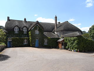
Soldon in the parish of Holsworthy Hamlets, Devon, England, is a historic estate, a seat of the Prideaux family. The manor house is a grade II listed building dating from the mid-16th century with later alterations. It was sold in 2014 as an eight bedroomed house with an acre and a half of grounds for an asking price of £750,000.
Robert of Aumale was one of the Devon Domesday Book tenants-in-chief of King William the Conqueror (1066-1087). His lands, comprising 17 entries in the Domesday Book of 1086, later formed part of the very large Feudal barony of Plympton, whose later barons were the Courtenay family, Earls of Devon.
Spencer Combe in the parish of Crediton, Devon, is an historic estate. The grade II listed farmhouse known today as "Spence Combe", the remnant of a former mansion house, is situated 3 miles north-west of the town of Crediton.

Upcott is an historic manor in the parish of Cheriton Fitzpaine, Devon. The manor house, known as Upcott Barton is a mediaeval grade II* listed building notorious in the history of Devon as the place where in 1455 the murder of the lawyer Nicholas Radford by a mob directed by the Earl of Devon during the Wars of the Roses took place. In the grounds is a reproduction of an Iron Age roundhouse built circa 2014.

Columb John in the parish of Broadclyst in Devon, England, is an historic estate and was briefly the seat of the prominent Acland family which later moved to the adjacent estate of Killerton. Nothing of the structure of the Acland mansion house survives except the arch to the gatehouse, dated about 1590, and the private chapel, restored in 1851. The site of the former mansion house is situated one mile due west of Killerton House, and five miles north-east of the historic centre of the City of Exeter. The estate's name derives from it having been held by the Culme family, whose own name was taken from its landholdings in the vicinity of the River Culm, which flows through the Columb John estate.

Orcheton is an historic estate in the parish of Modbury in Devon. The present house, known as Great Orcheton Farm is situated 1 1/2 miles south-west of Modbury Church.

Milton Abbot is a village, parish, and former manor in Devon, 6 miles (9.7 km) north-west of Tavistock, Devon, and 6 miles (9.7 km) south-east of Launceston, Cornwall.
Thorne in the parish of Ottery St Mary in Devon is an historic estate situated on the west side of the River Otter opposite the town of Ottery St Mary. The site is today occupied by Thorne Farm situated to the immediate north of the town's school and hospital and to the immediate south of the surviving early 17th century grand mansion house of Cadhay.

South Milton is a village and civil parish in Devon, England, situated on the south coast about 2 miles south-west of Kingsbridge. The civil parish includes the hamlets of Sutton, south of the village, and Upton, north of the village.
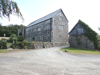
Collacombe is an historic manor in the parish of Lamerton, Devon, England. The manor house survives as a grade I listed building, known as Collacombe Barton or Collacombe Manor (House).
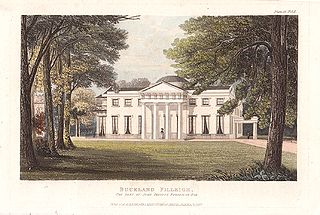
The manor of Buckland Filleigh was a manor in the parish of Buckland Filleigh in North Devon, England. Mentioned in the Domesday Book, the manor and its estates passed through several families, including over 300 years owned by the Fortescues.
Croker's Hele is an historic estate in the parish of Meeth in Devon, England.


