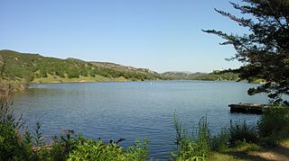
Lake Nacimiento is an 18-mile (29 km) long lake on the Nacimiento River in northern San Luis Obispo County, California. The lake contains many arms including Snake Creek and Dip Creek, nearer the dam, and the central Las Tablas and Franklin Creeks.

The Sierra Madre is a mountain range primarily in northern Santa Barbara County and extending into northwestern Ventura County in Southern California, western United States. It is a range of the Inner South Coast Ranges group, and is the southernmost reach of the California Coast Ranges, which are themselves part of the Pacific Coast Ranges of western North America.
The State Scenic Highway System in the U.S. state of California is a list of highways, mainly state highways, that have been designated by the California Department of Transportation (Caltrans) as scenic highways. They are marked by the state flower, a California poppy, inside either a rectangle for state-maintained highways or a pentagon for county highways.

The Santa Lucia Mountains or Santa Lucia Range is a rugged mountain range in coastal central California, running from Carmel southeast for 140 miles (230 km) to the Cuyama River in San Luis Obispo County. The range is never more than 11 miles (18 km) from the coast. The range forms the steepest coastal slope in the contiguous United States. Cone Peak at 5,158 feet (1,572 m) tall and three miles (5 km) from the coast, is the highest peak in proximity to the ocean in the lower 48 United States. The range was a barrier to exploring the coast of central California for early Spanish explorers.

The Carrizo Plain is a large enclosed grassland plain, approximately 50 miles (80 km) long and up to 15 miles (24 km) across, in southeastern San Luis Obispo County, California, about 100 miles (160 km) northwest of Los Angeles. It contains the 246,812-acre (99,881 ha) Carrizo Plain National Monument, and it is the largest single native grassland remaining in California. It includes Painted Rock in the Carrizo Plain Rock Art Discontiguous District, which is listed on the National Register of Historic Places. In 2012 it was further designated a National Historic Landmark due to its archeological value. The San Andreas Fault occurs along the eastern edge of the Carrizo Plain at the western base of the Temblor Range.

Cuyama is a census-designated place in Santa Barbara County. California. It is located in the Cuyama Valley, near the Carrizo Plain. The Cuyama River runs adjacent to the town, flowing west towards the Pacific Ocean. Cuyama is surrounded by many apricot, peach, and plum orchards. The ZIP Code is 93254, and the community is inside area code 805. The population was 57 at the 2010 census. The name "Cuyama" comes from an Indian village named Kuyam.

The Caliente Range is a west-east trending zone of uplift mountains in the California Coast Ranges, in central California. The highest peak of the range is Caliente Mountain at 5,106 feet (1,556 m) in elevation, located in southeastern San Luis Obispo County.

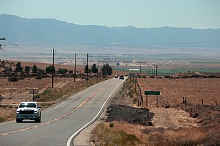
State Route 166 is a state highway in the U.S. state of California. It connects the Central Coast to the southern San Joaquin Valley, running from State Route 1 in Guadalupe and through Santa Maria in Santa Barbara County to State Route 99 in Mettler in Kern County.

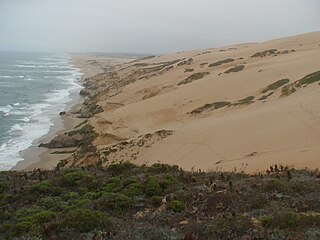
Guadalupe-Nipomo Dunes is the largest remaining dune system south of San Francisco and the second largest in the U.S. state of California. It encompasses an 18-mile (29 km) stretch of coastline on the Central Coast of California and extends from southern San Luis Obispo County to northern Santa Barbara County.

The Temblor Range is a mountain range within the California Coast Ranges, at the southwestern extremity of the San Joaquin Valley in California in the United States. It runs in a northwest-southeasterly direction along the borders of Kern County and San Luis Obispo County. The name of the range is from Spanish temblor meaning "tremor", referring to earthquakes. The San Andreas Fault Zone runs parallel to the range at the base of its western slope, on the eastern side of the Carrizo Plain, while the Antelope Plain, location of the enormous Midway Sunset, South Belridge, and Cymric oil fields, lies to the northeast.

The Nacimiento River is a 64.8-mile-long (104.3 km) river in southern Monterey County and northern San Luis Obispo County, California. A large portion of the river's run is on military reservations. The river's upper reaches are inside Fort Hunter Liggett, Lake Nacimiento is in the middle and the lower reaches are inside Camp Roberts. It is the largest tributary of the Salinas River in terms of streamflow.

Santa Margarita Lake, also called Salinas Reservoir, is a lake several miles southeast of the town of Santa Margarita in San Luis Obispo County, California. The lake was created by the building of Salinas Dam on the southern end of the Salinas River, very close to the river's origin in the Santa Lucia Range.

Nacimiento-Fergusson Road is the only road across the Santa Lucia Range on the Central Coast of California, connecting California State Route 1 and the Big Sur coast to U.S. Route 101 and the Salinas Valley. The road is well-paved and maintained over its length, but is winding and has precipitous drops. It is widely regarded as one of the best motorcycling roads in central California due to its ocean views and forest setting.

Areas of Critical Environmental Concern (ACEC) is a conservation ecology program in the Western United States, managed by the Bureau of Land Management (BLM). The ACEC program was conceived in the 1976 Federal Lands Policy and Management Act (FLPMA), which established the first conservation ecology mandate for the BLM. The FLPMA mandate directs the BLM to protect important riparian corridors, threatened and endangered species habitats, cultural and archeological resources, as well as unique scenic landscapes that the agency assesses as in need of special management attention.

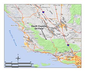
The South Cuyama Oil Field is a large oil and gas field in the Cuyama Valley and the adjacent northern foothills of the Sierra Madre Mountains in northeastern Santa Barbara County, California. Discovered in 1949, and with a cumulative production of around 225 million barrels (35,800,000 m3) of oil, it ranks 27th in size in the state, but is believed to retain only approximately two percent of its original oil, according to the official estimates of the California Department of Oil, Gas, and Geothermal Resources (DOGGR). Of the top forty onshore oil fields in California, it is the most recent to be discovered, but by the end of 2008 only 87 wells remained in production.

The Cuyama Valley is a valley along the Cuyama River in central California, in northern Santa Barbara, southern San Luis Obispo, southwestern Kern, and northwestern Ventura counties. It is about two hours driving time from both Los Angeles and the Santa Barbara area.

Bee Rock is a rural unincorporated community in northern San Luis Obispo County, California. Bee Rock is 3 miles (4.8 km) east-northeast of Tierra Redondo Mountain, in the southeastern Santa Lucia Range. It is located on Interlake Road, between Lake Nacimiento and Lake San Antonio reservoirs. It is known for having, in the 19th century, the "largest bee-hive in the world" housed within a granite boulder.
Sleeping Giant Wilderness Study Area is a non-motorized recreation area located on the west side of the Missouri River and Holter Lake located about 30 miles (48 km) north of Helena, Montana. Designated as a wilderness study area in 1981, the Sleeping Giant Wilderness Study Area contains approximately 6,666 acres (2,698 ha) of nearly roadless land, about half of which is forested. A portion of the Lewis and Clark National Historic Trail is contained inside the study area.
Oak Shores is a census-designated place in northern San Luis Obispo County, central California.

The Blanca Wetlands Area of Critical Environmental Concern, or Blanca Wildlife Habitat Area, is an area of the San Luis Valley in Colorado, United States, that serves as a refuge for birds, fish and other wildlife. It is about 11 miles (18 km) northeast of Alamosa on County Road 25. The wetlands had been completely destroyed by pumping and diversion of water for irrigation. Starting in 1965 the Bureau of Land Management began to restore them, and they have become an increasingly important ecological habitat for shorebirds, waterbirds and other wildlife and native plants.


