
Malappuram, is one of the 14 districts in the Indian state of Kerala, with a coastline of 70 km (43 mi). It is the most populous district of Kerala, which is home to around 13% of the total population of the state. The district was formed on 16 June 1969, spanning an area of about 3,554 km2 (1,372 sq mi). It is the third-largest district of Kerala by area, as well as the largest district in the state, bounded by Western Ghats and Arabian Sea to either side. The district is divided into seven Taluks: Eranad, Kondotty, Nilambur, Perinthalmanna, Ponnani, Tirur, and Tirurangadi.
Tirur is a municipality in Malappuram district in the Indian state of Kerala spread over an area of 16.55 square kilometres (6.39 sq mi). It is one of the business centers of Malappuram district and is situated 26 kilometres (16 mi) west of Malappuram and 52.5 kilometres (32.6 mi) south of Kozhikode, on the Shoranur–Mangalore section under Southern Railway. Tirur is also a major regional trading centre for fish and betel leaf and has an average elevation of 2 metres.
Feroke, is a Municipality and a part of Kozhikode metropolitan area under Kozhikode Development Authority (K.D.A) in the Kozhikode district of the Indian state of Kerala.

Kuttippuram is a town and a block headquarters, which is situated in the Tirur Taluk, Malappuram district of Kerala state, India. The town is located 34 kilometres south-west of Malappuram. The Bharathappuzha river flows through Kuttippuram. According to the last Census of India conducted in 2011, Kuttippuram forms a portion of the Malappuram metropolitan area.

Valanchery is a major town and one of the 12 municipalities in Malappuram district, Kerala, India. It is one of the four municipalities in Tirur Taluk, besides Tirur, Kottakkal, and Tanur. It is situated about 40 kilometres (25 mi) southeast to Karipur International Airport and 25 kilometres (16 mi) southwards to the district headquarters, and forms a part of Malappuram metropolitan area. It is also one of the major commercial towns under the Malappuram urban agglomeration. Valanchery, which was a part of the erstwhile princely state of the Valluvanad in the early medieval period, had been under the direct control of the Zamorin of Calicut following the Tirunavaya war of 14th century CE. During British Raj, Valanchery was included in the Ponnani Taluk of erstwhile Malabar District. Vattapara accident zone is an accident zone near Valanchery. Valanchery is situated on National Highway 66.

Tirunavaya, also spelled as Thirunavaya, is a town in Malappuram, Kerala. Situated on the northern bank of Bharatappuzha, it is one of major Hindu pilgrimage centres in Kerala. Tirunavaya, home to Tirunavaya Temple and temples of Siva and Brahma, is one of the most prominent places for bali tarpana on Karkitaka vavu in Kerala.
Athavanad is a village in the Tirur Taluk, in the Malappuram District of the state of Kerala, India. The town lies on the National Highway 17, between Kuttippuram and Valanchery. Puthanathani is the main town of the Athavanad village and the village office is located in Athavanad Para & Kurumbathoor. Nearby towns include Valanchery, Kalpakanchery, Tavanur, Tirunavaya, Kuttippuram, Irimbiliyam, and Edayur.
Kalpakanchery is a revenue village and a Gram Panchayat in Tirur Taluk, Malappuram district, Kerala, India. The village is located 21 kilometres (13 mi) south-west to the city of Malappuram.

Shoranur Junction is the railway station located at Shoranur, Palakkad District, Kerala. It comes under the Palakkad Railway Division of the Southern Railway. It is the largest railway station in the state of Kerala in terms of area. It is an important junction because it is the point at which the line from Chennai via Jolarpettai, Erode and Palakkad meets the coastal line from Mangalore to Kanyakumari. Further, Shoranur junction is the node from which a separate Branch line goes to the town of Nilambur, about 66 km to the north. The Nilambur–Shoranur line, which connects two tiny hill-towns, is one of the most picturesque in India.

Tirur Taluk comes under Tirur revenue division in Malappuram district of Kerala, India. Its headquarters is the town of Tirur. Tirur Taluk contains four municipalities - Tanur, Tirur, Kottakkal, and Valanchery. Most of the administrative offices are located in the Mini-Civil Stations at Tirur, Kuttippuram, and Tanur. Most of the villages in present-day Tirur Taluk were parts of the medieval Kingdom of Tanur (Vettathunadu). The port of Tanur was an important port town in the southwestern coast of India during medieval period.

Mulangunnathukavu railway station is in Mulakunnathukavu (മുളങ്കുന്നത്തുകാവ്), a panchayat in Puzhakkal block of Thrissur, which is situated between Wadakkanchery railway station and Punkunnam railway station in the busy Shoranur–Cochin Harbour section. Mulangunnathukavu railway station is operated by the Chennai-headquartered Southern Railways of the Indian Railways. The station is used as shuttle station for Thrissur railway station that is 10 kilometres (6.2 mi) south. It is just 250 metres (820 ft) away from State Highway 22 (Kerala). Ticketing is computerized and there are also basic parking facilities on site. A Food Corporation of India storage facility is located close nearby.
Puthanathani is a census town in Malappuram district in the state of Kerala, India. The town lies on the National Highway 66 (India), between Kottakkal and Valanchery. Roads to Vailathur and Thirunavaya also can be seen in Puthanathani.

Tirur railway station(Code:TIR) is the oldest railway station in Kerala. It is a major railway station serving the town of Tirur in Malappuram district of Kerala. It lies in the Shoranur–Mangalore section of the Southern Railways. Almost all passenger, Superfast and express trains have a halt here. The station has three platforms and four tracks. Though no trains originate from this station, trains halting at the station connect the town to prominent cities in India such as Thiruvananthapuram, Kochi, Kozhikode, Kollam, Thrissur, Kannur, Chennai, Mumbai, Bangalore, Coimbatore, Pondicherry, New Delhi, Mangalore, Pune, Jaipur, Jammu Tawi, Okha, Ahmedabad, Kolkata and so on. This is an "A" class railway station which earns more than 30 crore per annum. It has now been upgraded to a Model Railway Station (Adarsh). The first railway line in Kerala was commissioned on 12 March 1861 from Beypore to Tirur. The proposed high-speed rail has a stop in Tirur. The new backside entrance and parking area are being set up on the eastern side of the station, opening to Tirur Market.
Chaliyam is a village situated at the estuary of Chaliyar in Kozhikode district of Kerala, India. Chaliyam forms an island, bounded by the Chaliyar in the north, and River Kadalundi in south, and the Conolly Canal in the east. It is located just opposite to Beypore port. Chaliyam was the former terminus of the South-West Line of the Madras Railway. Chaliyam is also famous for the Guinness World Records holder Muhammed Adil, a P.M who covered around seven km in the Chaliyar River with his hand and legs tied with ropes.

Malappuram district is an education hub of the state of Kerala, India with four universities, two medical colleges, two law colleges and several engineering and arts colleges. The city has several educational institutions from the school level to higher education. Kendriya Vidyalaya, Jawahar Navodaya Vidyalaya, Malabar Special Police HSS, Government Girls Higher secondary school, Govt. Boys, St.Gemmas HSS, Islahiya HSS, A.U.P School, Sree Arunodaya Vidya Nigethan etc. to name a few schools. The city is lacking an Engineering College under Government despite having the largest number of students appearing and excelling in respective entrance exams. Govt. College, Malappuram, which is the oldest college in the city, started in 1972, College of Applied Science Malappuram and Govt. College for Women started this year along with many other private colleges serves the higher educational purpose. Govt.TTI and MCT TTI are few teachers training institutes. The Regional Directorate of Higher Secondary Education and Regional Office (Malabar) of State Open School are located in the city inside the Civil Station.
Malappuram is one of the 14 districts in the South Indian state of Kerala. The district has a unique and eventful history starting from pre-historic times. During the early medieval period, the district was the home to two of the four major kingdoms that ruled Kerala. Perumpadappu was the original hometown of the Kingdom of Cochin, which is also known as Perumbadappu Swaroopam, and Nediyiruppu was the original hometown of the Zamorin of Calicut, which is also known as Nediyiruppu Swaroopam. Besides, the original headquarters of the Palakkad Rajas were also at Athavanad in the district.
Athavanad is a village and Grama Panchayat in the Malappuram district, the Indian state of Kerala.

Vallikkunnu railway station is situated at Ariyallur, Vallikkunnu, Malappuram district, Kerala, India. It is one of the oldest railway stations in Kerala. This railway station was a part of first rail route (Tirur-Chaliyam) in Kerala. The station code for Vallikkunnu set by Indian Railway is VLI which can be used for various purposes including online reservations.
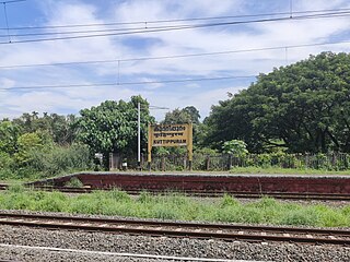
Kuttippuram railway station is a railway station in the Malappuram district, Kerala and falls under the Palakkad railway division of the Southern Railway zone, Indian Railways.

South Malabar refers to a geographical area of the southwestern coast of India covering some parts of the present-day Kerala. South Malabar covers the regions included in present-day Kozhikode taluk of Kozhikode district, the whole area of Malappuram district, Chavakkad taluk of Thrissur district, and Palakkad district, excluding parts of Chittur taluk. The Fort Kochi region of Kochi city also historically belongs to South Malabar. The term South Malabar refers to the region of the erstwhile Malabar District south to the river Korapuzha, and bears a high cultural similarity to both the Cochin and the North Malabar region.


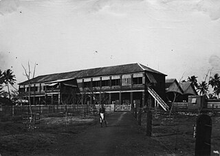
![Edakulam railway station ettkkullN rreyi[?]vee srrrreess[?] (1900).jpg](http://upload.wikimedia.org/wikipedia/commons/thumb/a/a3/%E0%B4%8E%E0%B4%9F%E0%B4%95%E0%B5%8D%E0%B4%95%E0%B5%81%E0%B4%B3%E0%B4%82_%E0%B4%B1%E0%B5%86%E0%B4%AF%E0%B4%BF%E0%B5%BD%E0%B4%B5%E0%B5%87_%E0%B4%B8%E0%B5%8D%E0%B4%B1%E0%B5%8D%E0%B4%B1%E0%B5%87%E0%B4%B7%E0%B5%BB_%281900%29.jpg/220px-%E0%B4%8E%E0%B4%9F%E0%B4%95%E0%B5%8D%E0%B4%95%E0%B5%81%E0%B4%B3%E0%B4%82_%E0%B4%B1%E0%B5%86%E0%B4%AF%E0%B4%BF%E0%B5%BD%E0%B4%B5%E0%B5%87_%E0%B4%B8%E0%B5%8D%E0%B4%B1%E0%B5%8D%E0%B4%B1%E0%B5%87%E0%B4%B7%E0%B5%BB_%281900%29.jpg)
