Titus Canyon

Last updated
Titus Canyon rock formations. Titus Canyon Narrows.jpg
Titus Canyon rock formations.
Titus Canyon Road, with view of Death Valley. Death Valley Titus Canyon 3.jpg
Titus Canyon Road, with view of Death Valley.

Titus Canyon is a deep, narrow gorge cut into the steep face of the Grapevine Mountains of the Mojave Desert, within Death Valley National Park in southeastern California and southwestern Nevada. The canyon features limestone rock formations, petroglyphs, and native plants and wildlife. [1] [2]

Grapevine Mountains mountain range in California and Nevada, United States

The Grapevine Mountains are a mountain range located along the border of Inyo County, California and Nye County, Nevada in the United States. The mountain range is about 22 miles (35 km) long and lies in a northwest-southeasterly direction along the Nevada-California state line. The range reaches an elevation of 8,738 feet (2,663 m) at Grapevine Peak, near Phinney Canyon on the Nevada side. Daylight Pass is at the southern end of the range. Most of the Grapevine Mountain chain is in Death Valley National Park.

Mojave Desert desert in southwestern United States

The Mojave Desert is an arid rain-shadow desert and the driest desert in North America. It is in the southwestern United States, primarily within southeastern California and southern Nevada, and it occupies 47,877 sq mi (124,000 km2). Very small areas also extend into Utah and Arizona. Its boundaries are generally noted by the presence of Joshua trees, which are native only to the Mojave Desert and are considered an indicator species, and it is believed to support an additional 1,750 to 2,000 species of plants. The central part of the desert is sparsely populated, while its peripheries support large communities such as Las Vegas, Barstow, Lancaster, Palmdale, Victorville, and St. George.

Death Valley National Park US national park in the state of California

Death Valley National Park is an American national park that straddles the California—Nevada border, east of the Sierra Nevada. The park boundaries include Death Valley, the northern section of Panamint Valley, the southern section of Eureka Valley, and most of Saline Valley. The park occupies an interface zone between the arid Great Basin and Mojave deserts, protecting the northwest corner of the Mojave Desert and its diverse environment of salt-flats, sand dunes, badlands, valleys, canyons, and mountains. Death Valley is the largest national park in the lower 48 states, and the hottest, driest and lowest of all the national parks in the United States. The second-lowest point in the Western Hemisphere is in Badwater Basin, which is 282 feet (86 m) below sea level. Approximately 91% of the park is a designated wilderness area. The park is home to many species of plants and animals that have adapted to this harsh desert environment. Some examples include creosote bush, bighorn sheep, coyote, and the Death Valley pupfish, a survivor from much wetter times. UNESCO included Death Valley as the principal feature of its Mojave and Colorado Deserts Biosphere Reserve in 1984.

Contents

Geology

Although the Grapevine Mountains were uplifted relatively recently, most of the rocks that make up the range are over half a billion years old. The gray rocks lining the walls of the western end of Titus Canyon are Cambrian age (570–505 million years old) limestone. These ancient Paleozoic rocks formed at a time when the Death Valley area was submerged beneath tropical seas. By the end of the Precambrian, the continental edge of North America had been planed off by erosion to a gently rounded surface of low relief. The rise and fall of the Cambrian seas periodically shifted the shoreline eastward, flooding the continent, then regressed westward, exposing the limestone layers to erosion. [3]

Tectonic uplift The portion of the total geologic uplift of the mean earth surface that is not attributable to an isostatic response to unloading

Tectonic uplift is the portion of the total geologic uplift of the mean Earth surface that is not attributable to an isostatic response to unloading. While isostatic response is important, an increase in the mean elevation of a region can only occur in response to tectonic processes of crustal thickening, changes in the density distribution of the crust and underlying mantle, and flexural support due to the bending of rigid lithosphere.

The Cambrian Period was the first geological period of the Paleozoic Era, and of the Phanerozoic Eon. The Cambrian lasted 55.6 million years from the end of the preceding Ediacaran Period 541 million years ago (mya) to the beginning of the Ordovician Period 485.4 mya. Its subdivisions, and its base, are somewhat in flux. The period was established by Adam Sedgwick, who named it after Cambria, the Latin name of Wales, where Britain's Cambrian rocks are best exposed. The Cambrian is unique in its unusually high proportion of lagerstätte sedimentary deposits, sites of exceptional preservation where "soft" parts of organisms are preserved as well as their more resistant shells. As a result, our understanding of the Cambrian biology surpasses that of some later periods.

The PaleozoicEra is the earliest of three geologic eras of the Phanerozoic Eon. It is the longest of the Phanerozoic eras, lasting from 541 to 251.902 million years ago, and is subdivided into six geologic periods : the Cambrian, Ordovician, Silurian, Devonian, Carboniferous, and Permian. The Paleozoic comes after the Neoproterozoic Era of the Proterozoic Eon and is followed by the Mesozoic Era.

The sediments have since been upturned, upfolded (forming anticlines), downfolded (forming synclines) and folded back onto themselves (forming recumbent folds).

Anticline geological term

In structural geology, an anticline is a type of fold that is an arch-like shape and has its oldest beds at its core. A typical anticline is convex up in which the hinge or crest is the location where the curvature is greatest, and the limbs are the sides of the fold that dip away from the hinge. Anticlines can be recognized and differentiated from antiforms by a sequence of rock layers that become progressively older toward the center of the fold. Therefore, if age relationships between various rock strata are unknown, the term antiform should be used.

Syncline

In structural geology, a syncline is a fold with younger layers closer to the center of the structure. A synclinorium is a large syncline with superimposed smaller folds. Synclines are typically a downward fold (synform), termed a synformal syncline, but synclines that point upwards can be found when strata have been overturned and folded.

Although some of the limestone exposed in the walls of Titus Canyon originated from thick mats of algae (stromatolites) that thrived in the warm, shallow Death Valley seas, most of the gray limestone shows little structure. Thousands of feet (hundreds of meters) of this limey goo were deposited in the Death Valley region. Similar limestone layers may be seen at Lake Mead National Recreation Area and at the bottom of the Grand Canyon. At one of the bends in the canyon, megabreccia can be seen.

Algae Group of eukaryotic organisms

Algae is an informal term for a large, diverse group of photosynthetic eukaryotic organisms that are not necessarily closely related, and is thus polyphyletic. Including organisms ranging from unicellular microalgae genera, such as Chlorella and the diatoms, to multicellular forms, such as the giant kelp, a large brown alga which may grow up to 50 m in length. Most are aquatic and autotrophic and lack many of the distinct cell and tissue types, such as stomata, xylem, and phloem, which are found in land plants. The largest and most complex marine algae are called seaweeds, while the most complex freshwater forms are the Charophyta, a division of green algae which includes, for example, Spirogyra and the stoneworts.

Stromatolite are rock-like structures

Stromatolites or stromatoliths are layered mounds, columns, and sheet-like sedimentary rocks that were originally formed by the growth of layer upon layer of cyanobacteria, a single-celled photosynthesizing microbe. Fossilized stromatolites provide records of ancient life on Earth. Lichen stromatolites are a proposed mechanism of formation of some kinds of layered rock structure that are formed above water, where rock meets air, by repeated colonization of the rock by endolithic lichens.

Lake Mead National Recreation Area U.S. National Recreation Area in Nevada and Arizona

Lake Mead National Recreation Area is a U.S. National Recreation Area located in southeastern Nevada and northwestern Arizona. Operated by the National Park Service, Lake Mead NRA follows the Colorado River corridor from the westernmost boundary of Grand Canyon National Park to just north of the cities of Laughlin, Nevada and Bullhead City, Arizona. It includes all of the eponymous Lake Mead as well as the smaller Lake Mohave – reservoirs on the river created by Hoover Dam and Davis Dam, respectively – and the surrounding desert terrain and wilderness.

History

Timbisha Native Americans carved petroglyphs on some of the rock faces in Titus Canyon, especially near natural springs.

The Timbisha are a Native American tribe federally recognized as the Death Valley Timbisha Shoshone Band of California. They are known as the Timbisha Shoshone Tribe and are located in south central California, near the Nevada border. As of the 2010 Census the population of the Village was 124. The older members still speak the ancestral language, also called Timbisha.

Petroglyph pictogram and logogram images carved on a rock surface

Petroglyphs are images created by removing part of a rock surface by incising, picking, carving, or abrading, as a form of rock art. Outside North America, scholars often use terms such as "carving", "engraving", or other descriptions of the technique to refer to such images. Petroglyphs are found worldwide, and are often associated with prehistoric peoples. The word comes from the Greek prefix petro-, from πέτρα petra meaning "stone", and γλύφω glýphō meaning "to carve", and was originally coined in French as pétroglyphe.

Ghost towns

Adjacent to the canyon proper is Leadfield, a former mining town and now ghost town where in the 1920s prospectors mined for ore after hearing exaggerated claims that lead would be easy to find and the living conditions in the area would be easy to endure.[ citation needed ] Another mining town-ghost town dating from the early 20th century, Rhyolite, Nevada, on the Tonopah and Tidewater Railroad, is also nearby to the east.

Leadfield, California Unincorporated community in California, United States

Leadfield was an unincorporated community, and historic mining town in Inyo County, California. It is now a ghost town. It is located in Titus Canyon in the Grapevine Mountains, east of Death Valley in Death Valley National Park. Leadfield lies at an elevation of 4,058 ft (1,237 m). It is on the National Register of Historic Places.

Ghost town city depopulated of inhabitants and that stays practically intact

A ghost town is an abandoned village, town, or city, usually one that contains substantial visible remains. A town often becomes a ghost town because the economic activity that supported it has failed, or due to natural or human-caused disasters such as floods, prolonged droughts, government actions, uncontrolled lawlessness, war, pollution, or nuclear disasters. The term can sometimes refer to cities, towns, and neighbourhoods that are still populated, but significantly less so than in past years; for example, those affected by high levels of unemployment and dereliction.

Prospecting The physical search for minerals

Prospecting is the first stage of the geological analysis of a territory. It is the physical search for minerals, fossils, precious metals or mineral specimens, and is also known as fossicking.

Mojave suncup (Camissonia brevipes) at the mouth of Titus Canyon. Mojave suncup flower at the mouth of Titus Canyon.JPG
Mojave suncup (Camissonia brevipes) at the mouth of Titus Canyon.

Ecology

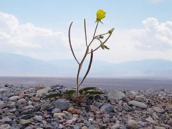
Several different types of flowering plants, including the sacred datura, inhabit the area. Desert Bighorn Sheep herds live in Titus Canyon, and the Funeral Mountains, particularly in the Klare Spring area of the canyon. [4]

Access

Titus Canyon is located above the east side of Death Valley, within Death Valley National Park. Access by foot from the west via Death Valley, or by vehicles from the east via Nevada. The one-way rough dirt road access begins west of the town of Beatty, Nevada. Vehicle travel is allowed only east to west through Titus Canyon, from the Daylight Pass Road−Nevada Highway 374 on the east, over a pass and down to the mouth of the canyon in Death Valley on the west. [1] [2]

See also

Related Research Articles

Geology of the Death Valley area

The exposed geology of the Death Valley area presents a diverse and complex set of at least 23 formations of sedimentary units, two major gaps in the geologic record called unconformities, and at least one distinct set of related formations geologists call a group. The oldest rocks in the area that now includes Death Valley National Park are extensively metamorphosed by intense heat and pressure and are at least 1700 million years old. These rocks were intruded by a mass of granite 1400 Ma and later uplifted and exposed to nearly 500 million years of erosion.

Places of interest in the Death Valley area

Places of interest in the Death Valley area are mostly located within Death Valley National Park in eastern California.

Kawaiisu

The Kawaiisu are a Native Californian ethnic group in the United States, which lives in the southern California Tehachapi Valley and across the Tehachapi Pass in the southern Sierra Nevada Mountains to the north, toward Lake Isabella and Walker Pass. Historically, the Kawaiisu also traveled eastward on food-gathering trips to areas in the northern Mojave Desert, to the north and northeast of the Antelope Valley, as far east as the Panamint Valley, the Panamint Mountains, and the western edge of Death Valley. Today, some Kawaiisu people are enrolled in the Tule River Indian Tribe.

<i>Salvia funerea</i> species of plant

Salvia funerea, with the common names Death Valley sage, woolly sage, and funeral sage, is an intricately branched shrub associated with limestone soils in the Mojave Desert in California and Nevada. It has an overall white appearance due to wooly hairs that cover the stems and leaves.

Panamint Valley desert

The Panamint Valley is a long basin located east of the Argus Range and Slate Range, and west of the Panamint Range in the northeastern reach of the Mojave Desert, in eastern California, United States.

Lanfair Valley

Lanfair Valley is located in the Mojave Desert in southeastern California near the Nevada state line. It is bounded on the north by the New York Mountains and Castle Mountains, on the east by the Piute Range, and on the south by the Woods Mountains and Vontrigger Hills. Joshua Trees can be found in most of the valley. Elevation is 4,045 feet.

Grapevine Canyon Petroglyphs

The Grapevine Canyon Petroglyphs are located in Grapevine Canyon on Spirit Mountain near Laughlin, Nevada, and are listed on the United States National Register of Historic Places. The area is also known as Christmas Tree Pass. While the petroglyphs extend through the canyon, a significant concentration lies at the entrance to the canyon which is at an elevation of 2,395 feet (730 m). The area features over 700 petroglyphs and many rock shelters.

Sylvania Mountains Wilderness

The Sylvania Mountains Wilderness is a federally designated wilderness area located 30 miles (48 km) east of Bishop in the state of California. The wilderness is 18,677acres in size and is managed by the Bureau of Land Management (BLM). The California Desert Protection Act of 1994 created the Sylvania Mountains Wilderness and was added to the National Wilderness Preservation System. The wilderness is bordered by Nevada stateline on the east, Piper Mountain Wilderness on the west and Death Valley National Park to the south.

Bullfrog Hills

The Bullfrog Hills are a small mountain range of the Mojave Desert in southern Nye County, southwestern Nevada. Bullfrog Hills was so named from a fancied resemblance of its ore to the color of a bullfrog.

Pahrump Valley

Pahrump Valley is a Mojave Desert valley west of Las Vegas and the Spring Mountains massif in southern Nye County, Nevada, and eastern San Bernardino County, California. Pahrump, Nevada, is in the valley's center and the Tecopa and Chicago Valleys are immediately to the west. The valley has routes to Death Valley and a route to Las Vegas.

Tonto Group

The Cambrian Tonto Group is the three-member sequence of geologic formations that represent the basal section of Paleozoic rocks in the Grand Canyon. The group is about 1,250 feet (381 m) thick. The base unit, the Cambrian Tapeats Sandstone was deposited upon the erosion surface of the Vishnu Basement Rocks, which is found in Granite Gorge. The erosion resistant Tapeats Sandstone forms the platform, called Tonto Platform, that the two less erosion resistant upper layers, the Bright Angel Shale and Muav Limestone, rest on.

Muav Limestone

The Cambrian Muav Limestone is the upper geologic unit of the 3-member Tonto Group. It is about 650 feet (198 m) thick at its maximum. It is a resistant cliff-forming unit. The Muav consists of dark to light-gray, brown, and orange red limestone with dolomite and calcareous mudstone. The Muav is overlain in some areas by the Devonian Temple Butte Limestone, but the major unit above are the vertical cliffs of Mississippian Redwall Limestone. The Muav is located in the lower elevations of the Grand Canyon, Arizona.

<i>Bristolia</i> genus of trilobites (fossil)

Bristolia is an extinct genus of trilobite, fossil marine arthropods, with eight or more small to average size species. It is common in and limited to the Lower Cambrian shelf deposits across the southwestern US, which constitutes part of the former paleocontinent of Laurentia.

The Wood Canyon Formation is a geologic formation in the northern Mojave Desert of Inyo County, California and Nye County and Clark County, Nevada.

The geology of Utah includes rocks formed at the edge of the proto-North American continent during the Precambrian. A shallow marine sedimentary environment covered the region for much of the Paleozoic and Mesozoic, followed by dryland conditions, volcanism and the formation of the basin and range terrain in the Cenozoic. Utah is a state in the western United States.

References

  1. 1 2 "Death Valley National Park - Titus Canyon". U.S. National Park Service. Retrieved 2009-12-31.
  2. 1 2 DesertUSA Blog: Titus Canyon in Death Valley National Park . accessed 4.5.2015
  3. "Death Valley geology field trip: Titus Canyon". U.S. Geological Survey. Retrieved 2016-03-31.
  4. "Death Valley National Park - Titus Canyon". U.S. National Park Service. Retrieved 2009-12-31.

Coordinates: 36°49′22″N117°10′24″W / 36.82278°N 117.17333°W / 36.82278; -117.17333