
Tacora is a stratovolcano located in the Andes of the Arica y Parinacota Region of Chile. Near the border with Peru, it is one of the northernmost volcanoes of Chile. It is part of the Central Volcanic Zone in Chile, one of the four volcanic belts of the Andes. The Central Volcanic Zone has several of the highest volcanoes in the world. Tacora itself is a stratovolcano with a caldera and a crater. The youngest radiometric age is 50,000 years ago and it is heavily eroded by glacial activity.

The Purico complex is a Pleistocene volcanic complex in Chile close to Bolivia, formed by an ignimbrite, several lava domes and stratovolcanoes and one maar. It is in the Chilean segment of the Central Volcanic Zone, one of the four volcanic belts which make up the Andean Volcanic Belt. The Central Volcanic Zone spans Peru, Bolivia, Chile and Argentina and includes 44 active volcanoes as well as the Altiplano–Puna volcanic complex, a system of large calderas and ignimbrites of which Purico is a member. Licancabur to the north, La Pacana southeast and Guayaques to the east are separate volcanic systems.

Paniri is a stratovolcano located in El Loa Province, Antofagasta Region, Chile, and near the border with Bolivia. To its northwest lie the twin volcanoes San Pedro and San Pablo, and to its southeast lies Cerro del León, from which it is separated by the huge Chao lava dome.

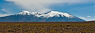
San Pedro is a Holocene composite volcano in northern Chile and at 6,155 metres (20,194 ft) in elevation one of the highest active volcanoes in the world. Part of the Chilean Andes' volcanic segment, it is part of the Central Volcanic Zone of the Andes, one of the four tracts of the Andean Volcanic Belt. This region of volcanism includes the world's two highest volcanoes Ojos del Salado and Llullaillaco. San Pedro, like other Andean volcanoes, was formed by the subduction of the Nazca Plate beneath the South America Plate. It has a neighbouring volcano, San Pablo, and is itself formed by two separate edifices usually known as the Old Cone and the Young Cone. These edifices are formed by rocks ranging from basaltic andesite over andesite to dacite and are emplaced on a basement formed by Miocene volcanic rocks.

Taapaca is a Holocene volcanic complex in northern Chile's Arica y Parinacota Region. Located in the Chilean Andes, it is part of the Central Volcanic Zone of the Andean Volcanic Belt, one of four distinct volcanic chains in South America. The town of Putre lies at the southwestern foot of the volcano.
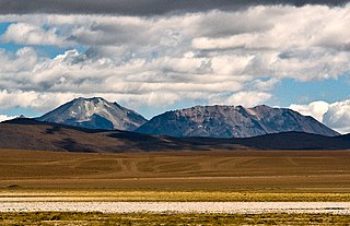
Cerro del León is a stratovolcano located in El Loa province, Antofagasta Region, Chile. It is part of the Chilean Central Volcanic Zone and forms a volcanic lineament with neighbouring Paniri and Toconce that was active into the Holocene. Cerro del León itself was constructed in three stages by andesitic–dacitic lava flows and was subject to glacial erosion.

Volcán Linzor is a stratovolcano on the border between Bolivia and Chile. In its vicinity lie Laguna Colorada and Cerro del León.
Cerro del Azufre is a stratovolcano located in El Loa Province, Antofagasta Region, Chile. It is part of a chain of volcanoes that separate Upper Loa River basin from Salar de Ascotán basin and is flanked to the west by a dacitic lava dome called Chanka or Pabellón. The 6000 metre volcanoes San Pedro and San Pablo are located to the southwest of Cerro del Azufre.

Cordón de Puntas Negras is a 500 km2 (193 sq mi) volcanic chain located east of the Salar de Atacama in Chile's Antofagasta Region.

The Altiplano–Puna volcanic complex, also known as APVC, is a complex of volcanic systems in the Puna of the Andes. It is located in the Altiplano area, a highland bounded by the Bolivian Cordillera Real in the east and by the main chain of the Andes, the Western Cordillera, in the west. It results from the subduction of the Nazca Plate beneath the South American Plate. Melts caused by subduction have generated the volcanoes of the Andean Volcanic Belt including the APVC. The volcanic province is located between 21° S–24° S latitude. The APVC spans the countries of Argentina, Bolivia and Chile.

Cerro Chao is a lava flow complex associated with the Cerro del León volcano in the Andes. It is the largest known Quaternary silicic volcano body and part of the most recent phase of activity in the Altiplano–Puna volcanic complex.

Tumisa is a Pleistocene stratovolcano in the Andes. Located east of the Salar de Atacama, it is part of the Central Volcanic Zone, which since the Miocene has been subject to extensive andesitic/dacitic effusive activity and ignimbrite eruptions. The basement on which Tumisa is built includes Paleozoic rocks and more recent volcanic products of the Lejia volcano and the Atana and Patao ignimbrites.
Chillahuita is a dacitic lava dome in northern Chile. It may have formed after the Pleistocene, although argon-argon dating on amphibole has indicated an age of 370,000 ± 40,000 years; another age estimate is 107,800 ± 6,400 years. It has an altitude of about 4,750 metres (15,580 ft). It formed in a single non-explosive eruption.
Cerro Tujle is a mafic volcanic centre in the Central Volcanic Zone of the Andes, Chile. It forms a 60 metres (200 ft) deep maar that may have formed half a million years ago. Its eruption products are aphyric. Previously in 1977, this crater has been identified as a meteor crater with diameters of 300 by 350 metres.
Irruputuncu is a volcano in the commune of Pica, Tamarugal Province, Tarapacá Region, Chile, as well as San Pedro de Quemes Municipality, Nor Lípez Province, Potosí Department, Bolivia. The mountain's summit is 5,163 m (16,939 ft) high and has two summit craters—the southernmost 200 m (660 ft)-wide one has active fumaroles. The volcano also features lava flows, block and ash flows and several lava domes. The volcano is part of the Andean Central Volcanic Zone (CVZ).

Sairecabur is a volcano located on the frontier between Bolivia and Chile. It is part of the Andean Central Volcanic Zone. Sairecabur proper is 5,971 m (19,590 ft) high; other mountains in the range are 5,722 m (18,773 ft) high Curiquinca, 5,819 m (19,091 ft) high Escalante and 5,748 m (18,858 ft) high Cerro Colorado, all of which have erupted a number of lava flows. Also in close proximity to Sairecabur lie the volcanic centres Licancabur, Putana and Juriques.

Apacheta-Aguilucho volcanic complex is a volcanic complex in Chile. It consists of two volcanoes Cerro Apacheta and Cerro Aguilucho, which are constructed mainly by lava flows and surrounded by outcrops of lava. A sector collapse and its landslide deposit are located on Apacheta's eastern flank. Two lava domes are associated with the volcanic complex, Chac-Inca and Pabellón.
Wheelwright caldera is a caldera in Chile. It is variously described as being between 11 kilometres (6.8 mi) and 22 kilometres (14 mi) wide and lies in the Central Volcanic Zone of the Andes. A lake lies within the caldera, which is among the largest of the Central Andes. The caldera lies in the region of Ojos del Salado, the world's tallest volcano.
Tocorpuri is a volcano in Chile, close to the border with Bolivia. Its peak height is most recently given as 5,808 metres (19,055 ft) and it features a 1.3 kilometres (0.81 mi) wide summit crater. The volcano consists mainly of lava flows and pyroclastic deposits and is subdivided into two separate edifices. Just west of Tocorpuri, the La Torta lava dome is a 200 metres (660 ft) high flat-topped structure. The volcanoes are formed by andesitic, dacitic and rhyolitic rocks.
Tilocálar is a group of volcanoes south of the Salar de Atacama, in Chile. It developed during the Pleistocene and consists of a small lava dome, two vents with numerous thick lava flows that reach lengths of several kilometres, and an explosion crater that was mistaken for an impact crater in the past. There are similar volcanoes nearby.

