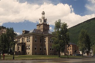
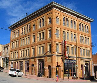
Telluride is the county seat and most populous town of San Miguel County in the southwestern portion of the U.S. state of Colorado. The town is a former silver mining camp on the San Miguel River in the western San Juan Mountains. The first gold mining claim was made in the mountains above Telluride in 1875, and early settlement of what is now Telluride followed. The town was founded in 1878 as "Columbia", but due to confusion with a California town of the same name, was renamed Telluride in 1887 for the gold telluride minerals found in other parts of Colorado. These telluride minerals were never found near Telluride, but the area's mines for some years provided zinc, lead, copper, silver, and other gold ores.

Cripple Creek is a statutory city that is the county seat of Teller County, Colorado, United States. The city population was 1,155 at the 2020 United States Census. Cripple Creek is a former gold mining camp located 20 miles (32 km) southwest of Colorado Springs near the base of Pikes Peak. The Cripple Creek Historic District, which received National Historic Landmark status in 1961, includes part or all of the city and the surrounding area. The city is now a part of the Colorado Springs, CO Metropolitan Statistical Area and the Front Range Urban Corridor.

The City of Leadville is a statutory city that is the county seat, the most populous community, and the only incorporated municipality in Lake County, Colorado, United States. The city population was 2,602 at the 2010 census and an estimated 2,762 in 2018. It is situated at an elevation of 10,152 feet (3,094 m).
San Juan County is a county located in the U.S. state of Colorado. As of the 2020 census, the population was 705, making it the least populous county in Colorado. The county seat and the only incorporated municipality in the county is Silverton. The county name is the Spanish language name for "Saint John", the name Spanish explorers gave to a river and the mountain range in the area. With a mean elevation of 11,240 feet (3426 meters), San Juan County is the highest county in the United States.

Ouray is a home rule municipality that is the county seat of Ouray County, Colorado, United States. The city population was 1,000 as of the 2010 census. The Ouray Post Office has the ZIP Code 81427. Ouray's climate, natural alpine environment, and scenery have earned it the nickname "Switzerland of America".
The City of Victor is a Statutory City in Teller County, Colorado, United States. Gold was discovered in Victor in the late 19th century, an omen of the future of the town. With Cripple Creek, the mining district became the second largest gold mining district in the country and realized approximately $10 billion of mined gold in 2010 dollars. It reached its peak around the turn of the century when there were about 18,000 residents in the town. Depleted ore in mines, labor strife and the exodus of miners during World War I caused a steep decline in the city's economy, from which it has never recovered. The population was 397 at the 2010 census. There is a resumed mining effort on Battle Mountain.

Climax was an unincorporated mining village and a former U.S. Post Office located in Lake County, Colorado, United States. Climax is known for its large molybdenum ore deposit. Climax is located along the Continental Divide at an elevation of about 11,360 feet. It was the highest human settlement in the United States, and it holds the record for having had the country's second highest Post Office and the highest railroad station.

Ludlow is a ghost town in Las Animas County, Colorado, United States. It was the site of the Ludlow Massacre–part of the Colorado Coalfield War–in 1914. The town site is located at the entrance to a canyon in the foothills of the Sangre de Cristo Mountains. It is located along the western side of Interstate 25 approximately 12 miles (19 km) north of the town of Trinidad. Nearby points of interest include the Ludlow Monument, a monument to the coal miners and their families who were killed in the 1914 massacre, the Hastings coke ovens, and the Victor American Hastings Mine Disaster Monument.

Mount Lincoln is the eighth-highest summit of the Rocky Mountains of North America and the U.S. state of Colorado. The prominent 14,293-foot (4356.5 m) fourteener is the highest summit of the Mosquito Range and the eleventh-highest summit in the contiguous United States. Mount Lincoln is located in Pike National Forest, 5.2 miles (8.3 km) north-northwest of the Town of Alma in Park County, Colorado, United States. The summit of Mount Lincoln is the highest point in Park County and the entire drainage basin of the Missouri River. The mountain was named in honor of Abraham Lincoln, 16th President of the United States.

Imogene Pass is a 13,114 ft (3,997 m) high mountain pass in the San Juan Mountains in the southwest part of the US state of Colorado.

St. Elmo is a ghost town in Chaffee County, Colorado, United States. Founded in 1880, St. Elmo lies in the heart of the Sawatch Range, 20 miles (32 km) southwest of Buena Vista and sits at an elevation of 9,961 feet (3,036 m). Nearly 2,000 people settled in this town when mining for gold and silver started. The mining industry started to decline in the early 1920s, and in 1922 the railroad discontinued service. The community is listed on the National Register of Historic Places as the St. Elmo Historic District. It is one of Colorado's best preserved ghost towns.
Silver Creek is a mining ghost town in Clear Creek County, Colorado, United States. The town never had a post office of its own, but received its mail via the Lawson post office. The town is only accessible via unimproved road. Most of the mines were located upstream from the town.

Ironton is a ghost town in Ouray County, Colorado, United States. It lay south of the present town of Ouray, adjacent to the sites Guston of Red Mountain Town, fellow ghost towns. During the 1880s and 1890s, Ironton formed part of the Red Mountain Pass mining district, the second largest silver mining district in Colorado.
Papeton, was a coal mining town, now in the area of Venetian Village, a neighborhood in Colorado Springs, Colorado, that is 1.4 miles (2.3 km) west southwest of Palmer Park. It is located at 6,184 feet (1,885 m) in elevation.
Adelaide, Colorado is a former mining camp and railroad water stop along what is now known as Phantom Canyon Road in Fremont County, Colorado. The elevation of the ghost town is 6,950 feet. The Adelaide Bridge is located just north of the townsite.
Norton's Landing or Norton's, was a steamboat landing on the Colorado River, in what was then Yuma County, Arizona Territory. Today it is in La Paz County, Arizona. Nortons Landing is 52 miles upriver from Yuma, Arizona 4 miles above Picacho, California and 18 miles below the Clip, Arizona landing. It lays on a rocky point of land next to the river at 215 feet of elevation just east of Red Cloud Wash and Black Rock Wash, where roads to the district mines in the mountains, met the Colorado River.

Guston is a silver mining ghost town in Ouray County, Colorado, 11 miles (18 km) south of Ouray following the "Million Dollar Highway". Nestled in Champion Gulch, it is located near Red Mountain and the remnants of Red Mountain Town and Ironton. The Silverton Railroad ran from Guston in the Red Mountain Pass to Silverton in San Juan County.

Berwind is a ghost town in Las Animas County, Colorado, nestled in Berwind Canyon 3.1 miles (5.0 km) southwest of Ludlow and 15 miles (24 km) northwest of Trinidad. The settlement was founded in 1888 as a company town for the Colorado Coal & Iron Company and, from 1892, was operated by the Colorado Fuel & Iron Company. It was a battle site in October 1913 and April 1914 during the Colorado Coalfield War, housing a Colorado National Guard encampment during the latter stages of the conflict.

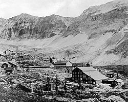
Chicago Peak is a 13,385-foot-elevation mountain summit located on the shared boundary of San Miguel County with Ouray County in southwest Colorado, United States. It is situated four miles (6.4 km) east of the community of Telluride, on land managed by Uncompahgre National Forest. It is part of the Sneffels Range which is a subset of the San Juan Mountains, which in turn are part of the Rocky Mountains. It is set above the ghost town of Tomboy, one mile (1.6 km) south of United States Mountain, and one mile northwest of Imogene Pass. Topographic relief is significant as the east aspect rises 2,000 feet (610 meters) above Imogene Basin in approximately one mile, and the west aspect rises 2,000 feet above Savage Basin in less than one mile. Mining activity in the immediate area produced significant amounts of gold and silver.

Ajax Peak is a 12,785-foot-elevation mountain summit located in San Miguel County of southwest Colorado, United States. It is situated on land managed by Uncompahgre National Forest, and is the iconic landmark visible three miles east of the community of Telluride. Ajax is set immediately south of Savage Basin and the ghost town of Tomboy, one mile southwest of Chicago Peak, and one mile west of Telluride Peak. It is also immediately northeast of Bridal Veil Falls, Colorado's highest waterfall at 365-feet high. It is part of the San Juan Mountains which are a subset of the Rocky Mountains. Topographic relief is significant as the west aspect rises 3,800 feet (1,160 meters) above the box canyon in approximately one mile. The old mill town of Pandora at the base of Ajax Peak was hit by snow slides each winter, and one particularly bad event in 1884 came over the Ajax Mine and wrecked the mills.