
The British National Space Centre (BNSC) was an agency of the Government of the United Kingdom, organised in 1985, that coordinated civil space activities for the UK. It was replaced on 1 April 2010 by the United Kingdom Space Agency (UKSA).

Satellite images are images of Earth collected by imaging satellites operated by governments and businesses around the world. Satellite imaging companies sell images by licensing them to governments and businesses such as Apple Maps and Google Maps.
IKONOS was a commercial Earth observation satellite, and was the first to collect publicly available high-resolution imagery at 1- and 4-meter resolution. It collected multispectral (MS) and panchromatic (PAN) imagery. The capability to observe Earth via space-based telescope has been called "one of the most significant developments in the history of the space age", and IKONOS brought imagery rivaling that of military spy satellites to the commercial market. IKONOS imagery began being sold on 1 January 2000, and the spacecraft was retired in 2015.
India's remote sensing program was developed with the idea of applying space technologies for the benefit of humankind and the development of the country. The program involved the development of three principal capabilities. The first was to design, build and launch satellites to a sun synchronous orbit. The second was to establish and operate ground stations for spacecraft control, data transfer along with data processing and archival. The third was to use the data obtained for various applications on the ground.
Surrey Satellite Technology Ltd, or SSTL, is a company involved in the manufacture and operation of small satellites. A spin-off company of the University of Surrey, it is presently wholly owned by Airbus Defence and Space.

The National Space Research and Development Agency (NASRDA) is the national space agency of Nigeria. It is a parastatal under Federal Ministry of Science and Technology. The agency is based in the Nigerian capital city of Abuja in the Lugbe district and has a ground receiving station, among various other sites. It has had cooperation in space technology with the United Kingdom, China, Ukraine and Russia. The agency has struggled with meeting its financial plans and some of its facilities are rundown. Despite this, the space agency is one of the most advanced space agencies in Africa, boasting of four satellites and very grand ambitions. Nigeria's satellites have been praised for their high-resolution images.
The Disaster Monitoring Constellation for International Imaging (DMCii) or just Disaster Monitoring Constellation (DMC) consists of a number of remote sensing satellites constructed by Surrey Satellite Technology Ltd (SSTL) and operated for the Algerian, Nigerian, Turkish, British and Chinese governments by DMC International Imaging. The DMC provides emergency Earth imaging for disaster relief under the International Charter for Space and Major Disasters, which the DMC formally joined in November 2005. Other DMC Earth imagery is used for a variety of civil applications by a variety of governments. Spare available imaging capacity is sold under contract.
UoSAT-12 is a British satellite in Low Earth Orbit. It is the twelfth satellite in the University of Surrey series and was designed and built by Surrey Satellite Technology Ltd. (SSTL). It was launched into orbit in April 1999 on board a Dnepr rocket from Yasny Russia.
DubaiSat-1 is a remote sensing Earth observation satellite built by the Emirates Institution for Advanced Science and Technology (EIAST) under an agreement with Satrec Initiative, a satellite manufacturing company in South Korea.
Deimos-1 is a Spanish Earth imaging satellite which is operated by Deimos Imaging who commercializes its imagery directly but also has distribution agreements with other entities like Astrium GEO and DMC International Imaging.
UK-DMC 2 is a British Earth imaging satellite which is operated by DMC International Imaging. It was constructed by Surrey Satellite Technology, based on the SSTL-100 satellite bus. It is part of Britain's contribution to the Disaster Monitoring Constellation, which is coordinated by DMC International Imaging. It is the successor to the UK-DMC satellite.

PROBA-V, or PROBA-Vegetation, is a satellite in the European Space Agency's PROBA series. It was launched in 2013 with a predicted usable lifetime between 2.5 and 5 years.
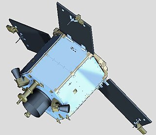
The Earth Remote Observation System-B (EROS-B) is the second satellite launched in a series of the EROS family of Israeli commercial Earth observation satellites, designed and manufactured by Israel Aircraft Industries (IAI). It is owned and operated by ImageSat International N.V. (ISI), in the Netherlands Antilles, Cayman Islands, with offices in Limassol, Cyprus, and in Tel Aviv, Israel.. Originally the satellite was to be the first of a constellation of 4 EROS-B satellites, but the 3 following satellites were cancelled, leaving the satellite to be the only EROS-B satellite.

The Algerian Space Agency, (ASAL) was established on January 16, 2002 in Bouzareah, Algiers. The agency is in charge of the Algerian space program. ASAL has flown five different satellites.

The Mohammed Bin Rashid Space Centre, is a Dubai government organisation working on the UAE space programme, which includes various space satellite projects, the Emirates Mars Mission, the Emirates Lunar Mission, and the UAE astronaut programme. The centre actively works to promote space science and research in the region. The centre encompasses the Emirates Institution for Advanced Science and Technology (EIAST).

DubaiSat-2 is an electro-optical Earth observation satellite built by the Emirates Institution for Advanced Science and Technology under an agreement with Satrec Initiative, a satellite manufacturing company in South Korea. EIAST's objective with DubaiSat-2 is to provide electro-optical images, that can be commercialized, for users within the United Arab Emirates and beyond and to develop and implement new technologies not used in DubaiSat-1. EIAST also intends to continue manpower training for the UAE's space program. 16 UAE engineers have been working on the design, development, testing and manufacturing of the satellite. The participation of the UAE engineers, who are currently working in South Korea, has increased by 100 percent from the DubaiSat-1 project.
BILSAT-1 was an earth observation satellite designed and developed by TÜBİTAK Space Technologies Research Institute and produced in Turkey as part of the Disaster Monitoring Constellation (DMC) project in the context of a show-how program led by DMC International Imaging of Surrey Satellite Technology (SSTL).

EgyptSat 2 was Egypt's second remote sensing Earth observation satellite. It was built by the Russian RSC Energia and the Egyptian NARSS while the incorporated cameras and payload was developed by OAO Peleng and NIRUP Geoinformatsionnye Sistemy in Belarus.

KhalifaSat, also known as DubaiSat-3, is a remote sensing Earth observation satellite that was designed and built at the Space Technology Laboratories of the Mohammed bin Rashid Space Centre in Dubai. It is considered the first entirely Emirati-made satellite. It launched into orbit on 30 October 2018 from Japan's Tanegashima Space Center using the Korean Satrec SI-300 bus.
The International Charter "Space and Major Disasters" is a non-binding charter which provides for the charitable and humanitarian acquisition and transmission of satellite data to relief organizations in the event of major disasters. Initiated by the European Space Agency and the French space agency CNES after the UNISPACE III conference held in Vienna, Austria, in July 1999, it officially came into operation on November 1, 2000, after the Canadian Space Agency signed onto the charter on October 20, 2000. Their space assets were then, respectively, ERS and ENVISAT, SPOT and Formosat, and RADARSAT.
