Topalu

Last updated • 1 min readFrom Wikipedia, The Free Encyclopedia
Topalu
Topalu jud Constanta.jpg
Location in Constanța County
Romania location map.svg
Red pog.svg
Topalu
Location in Romania
Coordinates: 44°33′N28°3′E / 44.550°N 28.050°E / 44.550; 28.050
CountryRomania
County Constanța
SubdivisionsTopalu, Capidava
Government
  Mayor (20202024) Constantin Baltă [1] (PSD)
Area
79.29 km2 (30.61 sq mi)
Population
 (2021-12-01) [2]
1,517
  Density19/km2 (50/sq mi)
Time zone EET/EEST (UTC+2/+3)
Vehicle reg. CT
Website www.primariatopalu.ro

Topalu is a commune located on the right bank of the Danube in Constanța County, Northern Dobruja, Romania.

Contents

Administration

The commune includes two villages:

Demographics

Historical population
YearPop.±%
2002 1,951    
2011 1,785−8.5%
2021 1,517−15.0%
Source: National Institute of Statistics [3]

At the 2011 census, Topalu had 1,707 Romanians (99.94%), 1 others (0.06%). [4]

History

Capidava on Tabula Peutingeriana (upper center) Part of Tabula Peutingeriana showing Eastern Moesia Inferior, Eastern Dacia and Thrace.png
Capidava on Tabula Peutingeriana (upper center)

Tabula Peutingeriana

Capidava is depicted in the form Calidava/Calidaua in Segmentum VIII of Tabula Peutingeriana (1st-4th century AD) on a Roman road between Axiopolis and Carsium. [5] [6] The map provides accurate data on the distances between Axiopolis, Capidava and Carsium. These distances coincide with the distances between the present localities of Hinog - Capidava and Capidava - Hârșova. This is also verified by the discovery of military marking pillar at Seimenii Mici that indicates the distance of 18,000 feet (27 km) from Axiopolis to Capidava. [7]

Ancient times

Ruins of the Geto-Dacian fortress Capidava Capidava.jpg
Ruins of the Geto-Dacian fortress Capidava

The village Capidava is the site of the fortified Geto-Dacian center with the same name, Capidava.

After the Roman conquest of Dacia it became a Roman city and castra in the province of Scythia Minor (modern Dobruja).

Etymology

Capidava is a Getic toponym, meaning the "curve fortified settlement". [7]

See also

Related Research Articles

<span class="mw-page-title-main">Northern Dobruja</span> Geographical region in south-eastern Romania

Northern Dobruja is the part of Dobruja within the borders of Romania. It lies between the lower Danube River and the Black Sea, bordered in the south by Southern Dobruja, which is a part of Bulgaria.

<span class="mw-page-title-main">Hârșova</span> Town in Constanța, Romania

Hârșova is a town located on the right bank of the Danube, in Constanța County, Northern Dobruja, Romania.

<span class="mw-page-title-main">Apulon</span>

Apulon was a Dacian fortress city close to modern Alba Iulia, Romania. The Latin name of Apulum is derived. The exact location is believed by many archaeologists to be the Dacian fortifications on top of Piatra Craivii, Craiva, Cricău, about 20 km north of Alba-Iulia.

Aelius Catus was a Roman commander near the Danube who, according to Strabo's geography, transplanted 50,000 Getae from what is now Muntenia in Romania far to the south of Danube, in Moesia.

<span class="mw-page-title-main">Sucidava</span> Dacian and Daco-Roman historical site in Corabia, Romania

Sucidava was a Dacian and Daco-Roman city situated in Corabia, Romania, on the north bank of the Danube. It developed from the 270s AD and especially after the construction of Constantine's Bridge the northern side of which it protected.

<span class="mw-page-title-main">Gârliciu</span> Commune in Constanța, Romania

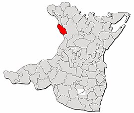
Gârliciu is a commune in Constanța County, Northern Dobruja, Romania, containing the village with the same name.

<span class="mw-page-title-main">Argidava</span> Dacian fortress town, located in Caraș-Severin county, Romania

Argidava was a Dacian fortress town close to the Danube, inhabited and governed by the Albocense. Located in today's Vărădia, Caraș-Severin County, Romania.

<span class="mw-page-title-main">Acidava</span>

Acidava (Acidaua) was a Dacian and later Roman town and fort on the Olt river near the lower Danube. The settlement's remains are located in today's Enoşeşti, Olt County, Oltenia, Romania.

<span class="mw-page-title-main">Aizis</span>

Aizis was a Dacian town mentioned by Emperor Trajan in his work Dacica. Located at Dealul Ruieni, Fârliug, Caraș-Severin, Banat, Romania.

<span class="mw-page-title-main">Zurobara</span> Dacian town

Zurobara was a Dacian town located in the northwest of today's Romanian Banat. It was positioned by the Tibiscus (Timiș) river, north of Sarmizegetusa Regia and south of Ziridava.

<i>Dava</i> (Dacian) Dacian fortified settlement

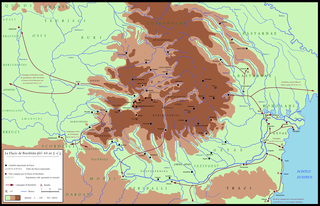
Dava was a Geto-Dacian name for a city, town or fortress. Generally, the name indicated a tribal center or an important settlement, usually fortified. Some of the Dacian settlements and the fortresses employed the Murus Dacicus traditional construction technique.

<span class="mw-page-title-main">Amutria</span>

Amutria was a Dacian town close to the Danube and included in the Roman road network, after the conquest of Dacia.

<span class="mw-page-title-main">Capidava</span> Archaeological site in Romania

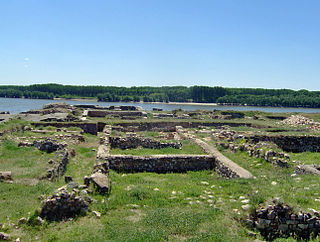
Capidava was originally an important Geto-Dacian centre on the right bank of the Danube. After the Roman conquest, it became a civil and military centre in the province of Moesia Inferior and part of the defensive frontier system of the Moesian Limes along the Danube.

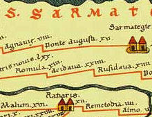
Rusidava was a Dacian town mentioned in Tabula Peutingeriana between Acidava and Pons Aluti, today's Drăgășani, Vâlcea County, Romania.

<span class="mw-page-title-main">Sacidava, Moesia</span> Ancient Getic settlement

Sacidava was an ancient Getic settlement on the Danube, between Durostorum and Axiopolis, located near the modern village of Izvoarele, in Romania.

<span class="mw-page-title-main">Ziridava</span> Dacian fortified settlement

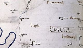
Ziridava was a Dacian town located between Apulon and Tibiscum, mentioned by Ptolemy in the area of the Dacian tribe of Biephi.

<span class="mw-page-title-main">Carsium (castra)</span> Fortress in Romania

Carsium was a fort in the Roman province of Moesia in the 1st century AD whose remains are still visible. It was part of the defensive frontier system of the Limes Moesiae along the Danube.

<span class="mw-page-title-main">Potaissa (castra)</span>

Potaissa was a legionary fortress and later a city in the Roman province of Dacia, located in today's Turda, Romania.

References

  1. "Results of the 2020 local elections". Central Electoral Bureau. Retrieved 15 June 2021.
  2. "Populaţia rezidentă după grupa de vârstă, pe județe și municipii, orașe, comune, la 1 decembrie 2021" (XLS). National Institute of Statistics.
  3. "Constanta (Romania) - Cities, Towns, and Communes". citypopulation.de. Retrieved 7 January 2024.
  4. "Constanța County at the 2011 census" (PDF) (in Romanian). INSSE. February 2, 2012. Archived from the original (PDF) on March 24, 2012. Retrieved March 8, 2012.
  5. Anonymous. "Segmentum VIII,3". Tabula Peutingeriana (in Latin). 1-4th century AD.
  6. Olteanu, Sorin. "Categorii de toponime în funcţie de origine şi aşezare" [Toponymy categories according to origin and location]. Linguae Thraco-Daco-Moesorum (in Romanian). Archived from the original on 16 July 2011. Retrieved 3 January 2010.
  7. 1 2 Florescu, Radu; Manea, Florentina. Oberländer-Târnoveanu, Irina; Bor, Corina (eds.). "Capidava". Bucharest, Romania: Institute for Cultural Memory (Institutul de Memorie Culturală) - cIMeC. Archived from the original on 31 October 2010. Retrieved 2 February 2011.

Further reading