Empire is an unincorporated community and census-designated place (CDP) in Washoe County, Nevada, with a population estimated at 65 (2021). It is part of the Reno–Sparks Metropolitan Statistical Area; before the 2010 census, it was part of the Gerlach–Empire census-designated place. The nearest town, Nixon, is 60 miles (97 km) to the south on a reservation owned by the Pyramid Lake Paiute Tribe.

The Nightingale Mountains are a north–south trending range located along the western border of Pershing County and extending into the northeastern corner of Washoe County. The range has a length of 32.2 km (20.0 mi) and a width of about 5.5 km (3.4 mi). The highest peak has an elevation of 2,511 m (8,238 ft) which is 1,353 m (4,439 ft) above the elevation of the dry Winnemucca Lake bed at about 1,158 m (3,799 ft).

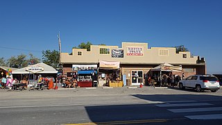
Silver Peak is an unincorporated community and census-designated place (CDP) in Esmeralda County, Nevada, United States. It lies along State Route 265, 20 miles (32 km) south of U.S. Route 6 and 30 miles (48 km) west of Goldfield, the county seat of Esmeralda County. It has a post office, with the ZIP code of 89047. The population of Silver Peak was 142 as of 2019.

Coaldale is a former mining town and true ghost town in Esmeralda County, Nevada, located at the junction of U.S. Route 6 and U.S. Route 95 about 40 miles (64 km) west of Tonopah.

Cactus Springs is a ghost town in Nye County, Nevada. It is currently within the boundaries of the Nellis Air Force Range.

Ione, Nevada, is a ghost town in Nye County, Nevada, located approximately 23 miles east of Gabbs, Nevada.
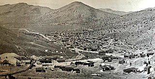
Rochester, Nevada, was a silver-mining town in Pershing County, Nevada, USA, approximately 110 mi (180 km) east of Reno. It is now a ghost town. Lower Rochester is still accessible to visitors, but was largely destroyed by a wildfire in 2012; Upper Rochester has been buried under mine tailings of the more recent Coeur Rochester open pit mine.

Drakelands Mine, formerly known as Hemerdon Mine or the Hemerdon Ball or Hemerdon Bal Mine, is a tungsten and tin mine. It is located 11 km northeast of Plymouth, near Plympton, in Devon, England. It lies to the north of the villages of Sparkwell and Hemerdon and adjacent to the large china clay pits near Lee Moor. The mine was out of operation since 1944, except for the brief operation of a trial mine in the 1980s. Work started to re-open it in 2014, but it ceased activities in 2018. It hosts the fourth largest tin-tungsten deposit in the world. A new company, Tungsten West, now plan to re open the mine in 2022, after investing to alter the processing plant. A ground up review lead to the recognition that the ore is not in fact Wolframite, but is in fact a related ore, Ferberite, and changes were needed to improve extraction efficiencies. In addition, a subsidiary will enhance the mine with aggregate sales as a by product of mining.

Goldstrike is a gold mine in Eureka County in north-eastern Nevada. It is located on the Carlin Trend, a prolific gold mining district. It is owned and operated by Barrick Gold. Since Barrick acquired Goldstrike in 1986, until 2018 it produced 44.4 million ounces of gold.
Roach is a ghost town and railroad siding in Clark County, Nevada, United States. It is located along the Union Pacific Railroad, between Jean, Nevada and Nipton, California.
Tungstonia, Nevada, is a ghost town on the Southern flank of the Kern Mountains of Eastern White Pine County, Nevada, along Tungstonia Wash.

Mazuma, Nevada was a small mining town in Pershing County, Nevada where eight people were killed in a flash flood on July 11, 1912.
Athens is a former mining settlement in Nye County, Nevada. It was established after a boom in 1910, but was deserted that same year. After the Warrior mine was founded, Athens revived and was inhabited until 1939, when the mining operations were ceased.
Eagleville is a former populated place in Mineral County, Nevada that is now a ghost town.
Lodi is an extinct town in Nye County, in the U.S. state of Nevada. The GNIS classifies it as a populated place.
Farrell is a ghost town in Pershing County, Nevada, United States.
Tempiute is a ghost town in Lincoln County, Nevada United States.
Pyramid City is a ghost town located south of Sutcliffe, Nevada. This location was also sometimes known as Pyramid and should not be confused with Pyramid, Nevada, located north of Sutcliffe. Pyramid City consisted of two mining camps, Upper Pyramid and Lower Pyramid, also known as Pyramid City.
Oreana is a ghost town in Pershing County, Nevada, United States.


