Imlay, Nevada

Last updated

Imlay, Nevada
Rye Patch and Pitt-Taylor Reservoirs and Lassens Meadows.jpg
Imlay (at lower right) is near the Lassens Meadows, above Rye Patch Reservoir, on the Humboldt River.
Flag of Imlay, Nevada.jpg
USA Nevada location map.svg
Red pog.svg
Imlay
Coordinates: 40°39′39″N118°09′02″W / 40.66083°N 118.15056°W / 40.66083; -118.15056 [1]
Country United States
State Nevada
Area
[2]
  Total1.18 sq mi (3.06 km2)
  Land1.18 sq mi (3.06 km2)
  Water0.00 sq mi (0.00 km2)
Elevation
[1]
4,203 ft (1,281 m)
Population
 (2020)
  Total210
  Density177.66/sq mi (68.58/km2)
Time zone UTC-8 (Pacific (PST))
  Summer (DST) UTC-7 (PDT)
ZIP code
89418 [3]
Area code 775
FIPS code 32-34700
GNIS feature ID0841225 [1]

Imlay is an unincorporated town in Pershing County, Nevada, United States. [4] It has an elementary school, a general store, a post office, and a trading post. As of the 2010 census, the population was 171. [5]

Contents

It is a nearly abandoned railroad town, named for a nearby mine or for the civil engineer who surveyed the town circa 1907. [6] [7] Its most notable feature is a series of strange buildings called Thunder Mountain Monument. These structures were built as a monument to Native American culture by a World War II veteran who called himself Thunder. [8]

Michael Feldman's Whad'Ya Know? public radio show featured Imlay as the "Town of the Week" on its December 5, 2009, show. They mentioned Thunder Mountain Monument [9] as one of the premier draws to the area.

Remarks by Franklin D. Roosevelt during 1938 visit to Imlay Informal Remarks of the President in Imlay, Nevada - NARA - 197812.jpg
Remarks by Franklin D. Roosevelt during 1938 visit to Imlay

Geography

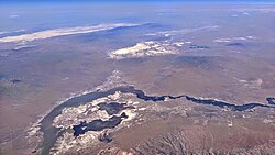
Imlay is located in northern Pershing County, Nevada, along Interstate 80, with access from Exit 145. The town is 34 miles (55 km) west of Winnemucca and 40 miles (64 km) northeast of Lovelock. The Humboldt River flows past 2 miles (3 km) to the north, near its inlet into Rye Patch Reservoir.

According to the U.S. Census Bureau, the census-designated place of Imlay has an area of 34.5 square miles (89.4 km2), all land. [5]

Climate

According to the Köppen Climate Classification system, Imlay has a cold semi-arid climate, abbreviated "BSk" on climate maps. The hottest temperature recorded in Imlay was 112 °F (44.4 °C) on July 17, 1959, while the coldest temperature recorded was −35 °F (−37.2 °C) on January 17, 1917 and December 25, 1924. [10]

Climate data for Imlay, Nevada, 1991–2020 normals, extremes 1914–present
MonthJanFebMarAprMayJunJulAugSepOctNovDecYear
Record high °F (°C)70
(21)
76
(24)
82
(28)
90
(32)
99
(37)
108
(42)
112
(44)
106
(41)
104
(40)
98
(37)
82
(28)
78
(26)
112
(44)
Mean maximum °F (°C)56.9
(13.8)
63.0
(17.2)
72.1
(22.3)
79.8
(26.6)
88.3
(31.3)
96.4
(35.8)
101.4
(38.6)
99.4
(37.4)
93.4
(34.1)
83.0
(28.3)
68.6
(20.3)
58.3
(14.6)
102.1
(38.9)
Mean daily maximum °F (°C)41.6
(5.3)
47.5
(8.6)
56.1
(13.4)
61.6
(16.4)
71.1
(21.7)
81.5
(27.5)
92.0
(33.3)
90.1
(32.3)
80.6
(27.0)
66.6
(19.2)
51.6
(10.9)
40.7
(4.8)
65.1
(18.4)
Daily mean °F (°C)30.7
(−0.7)
35.3
(1.8)
42.0
(5.6)
47.3
(8.5)
56.4
(13.6)
65.8
(18.8)
74.8
(23.8)
71.9
(22.2)
62.6
(17.0)
49.6
(9.8)
37.7
(3.2)
29.4
(−1.4)
50.3
(10.2)
Mean daily minimum °F (°C)19.9
(−6.7)
23.2
(−4.9)
27.9
(−2.3)
33.1
(0.6)
41.8
(5.4)
50.1
(10.1)
57.7
(14.3)
53.7
(12.1)
44.5
(6.9)
32.7
(0.4)
23.7
(−4.6)
18.0
(−7.8)
35.5
(2.0)
Mean minimum °F (°C)2.4
(−16.4)
8.3
(−13.2)
14.2
(−9.9)
19.3
(−7.1)
27.6
(−2.4)
35.0
(1.7)
46.7
(8.2)
41.9
(5.5)
30.4
(−0.9)
17.5
(−8.1)
7.3
(−13.7)
−1.8
(−18.8)
−4.9
(−20.5)
Record low °F (°C)−35
(−37)
−28
(−33)
−5
(−21)
10
(−12)
17
(−8)
26
(−3)
28
(−2)
29
(−2)
16
(−9)
2
(−17)
−6
(−21)
−35
(−37)
−35
(−37)
Average precipitation inches (mm)0.92
(23)
0.83
(21)
1.16
(29)
0.96
(24)
1.08
(27)
0.56
(14)
0.20
(5.1)
0.19
(4.8)
0.27
(6.9)
0.63
(16)
0.66
(17)
0.93
(24)
8.39
(211.8)
Average snowfall inches (cm)2.9
(7.4)
1.2
(3.0)
1.8
(4.6)
0.8
(2.0)
0.0
(0.0)
0.0
(0.0)
0.0
(0.0)
0.0
(0.0)
0.0
(0.0)
0.0
(0.0)
0.8
(2.0)
4.1
(10)
11.6
(29)
Average precipitation days (≥ 0.01 in)6.66.56.46.56.53.01.91.62.03.64.46.655.6
Average snowy days (≥ 0.1 in)1.91.41.00.60.00.00.00.00.00.10.93.08.9
Source 1: NOAA [11]
Source 2: National Weather Service [10]

Demographics

Historical population
CensusPop.Note
2020 210
U.S. Decennial Census [12]

Related Research Articles

<span class="mw-page-title-main">Pershing County, Nevada</span> County in Nevada, United States

Pershing County is a county in the U.S. state of Nevada. As of the 2020 census, the population was 6,650. Its county seat is Lovelock. The county was named after army general John J. Pershing (1860–1948). It was formed from Humboldt County in 1919, and the last county to be established in Nevada. The Black Rock Desert, location for the annual Burning Man event, is partially in the county. The county is listed as Nevada Historical Marker 17. The marker is at the courthouse in Lovelock.

<span class="mw-page-title-main">Humboldt County, Nevada</span> County in Nevada, United States

Humboldt County is a county in the U.S. state of Nevada. As of the 2020 Census, the population was 17,285. It is a largely rural county that is sparsely populated with the only major city being Winnemucca which has a population of 8,431. Humboldt County comprises the Winnemucca, NV Micropolitan Statistical Area and serves as an important crossroads in the national transportation network. Interstate 80 travels through the southeastern corner of the county, meeting US 95 in Winnemucca that serves as a primary freight corridor between Northern Nevada and Boise, Idaho and the Interstate 84 freight corridor that links much of the Pacific Northwest. The original transcontinental railway, constructed by the Central Pacific Railroad, reached Humboldt County on Sept. 16, 1868. The Western Pacific Railroad would reach Humboldt County by November 1909, providing two mainline rail links to California and the Eastern United States. Both railroads have since been acquired by the Union Pacific Railroad, who continues to serve the region today.

<span class="mw-page-title-main">Elko, Nevada</span> City in Nevada, United States

Elko is a city in the U.S. state of Nevada and the county seat of Elko County. As of the official 2020 U.S. Census, the city has a population of 20,564. Elko serves as the center of the Ruby Valley, a region with a population of over 55,000. Elko is 21 miles (34 km) from Lamoille Canyon and the Ruby Mountains, providing year round access to recreation including hiking, skiing, hunting, and more than 20 alpine lakes. The city straddles the Humboldt River. Spring Creek, Nevada, serves as a bedroom community 6 miles (10 km) from the city with a population of 13,805.

<span class="mw-page-title-main">McDermitt, Nevada and Oregon</span> Unincorporated community in the state of Nevada, United States

McDermitt is an unincorporated community straddling the Nevada–Oregon border, in Humboldt County, Nevada, and Malheur County, Oregon, United States. McDermitt's economy has historically been based on mining, ranching, and farming. The last mining operation closed in 1990, resulting in a steady decline in population.

<span class="mw-page-title-main">Battle Mountain, Nevada</span> Unincorporated town in the State of Nevada, United States

Battle Mountain is an unincorporated town in and the county seat of Lander County, Nevada, United States. The population was 3,705 at the 2020 census. Its primary economic base is gold mining and, to a lesser extent, legalized gambling.

<span class="mw-page-title-main">Beatty, Nevada</span> Unincorporated town in Nevada, United States

Beatty is an unincorporated town along the Amargosa River in Nye County, Nevada, United States. U.S. Route 95 runs through the town, which lies between Tonopah, about 90 miles (140 km) to the north and Las Vegas, about 120 miles (190 km) to the southeast. State Route 374 connects Beatty to Death Valley National Park, about 8 miles (13 km) to the west.

<span class="mw-page-title-main">Lovelock, Nevada</span> Incorporated city in Nevada, United States

Lovelock is the county seat of Pershing County, Nevada, United States, in which it is the only incorporated city.

<span class="mw-page-title-main">Jackpot, Nevada</span> Census-designated place in Nevada, United States

Jackpot is an unincorporated community and census-designated place (CDP) in Elko County, Nevada, United States. The population was 855 as of the 2020 census. Located less than one mile (1.6 km) from the Idaho border on US 93, Jackpot has been a popular casino gaming destination for residents of Idaho and other neighboring states since its founding.

<span class="mw-page-title-main">Jarbidge, Nevada</span> Unincorporated community in Nevada, US

Jarbidge is an unincorporated community in Elko County, Nevada, United States. Located at the bottom of the Jarbidge River's canyon near the north end of the Jarbidge Mountains, it lies within the Jarbidge Ranger District of the Humboldt-Toiyabe National Forest and is near the northwest edge of the Jarbidge Wilderness, approximately 10 miles (16 km) south of the Idaho–Nevada border.

<span class="mw-page-title-main">Mina, Nevada</span> Census-designated place in Nevada, United States

Mina is a census-designated place in Mineral County in west-central Nevada, United States. It is located along U.S. Route 95 at an elevation of 4,560 feet (1,390 m). The 2010 population was 155.

<span class="mw-page-title-main">Golconda, Nevada</span> Census-designated place in Nevada, United States

Golconda is a census-designated place in southeastern Humboldt County, Nevada, United States. As of the 2020 census it has a population of 182. It is located along Interstate 80 on the Humboldt River in the northwestern part of the state. Golconda has a post office, which has been in operation since 1869.

<span class="mw-page-title-main">Orovada, Nevada</span> Census-designated place in Nevada, United States

Orovada is a census-designated place in Humboldt County, Nevada. The population was 155 at the 2010 census.

<span class="mw-page-title-main">Mountain City, Nevada</span> Census-designated place in Nevada, United States

Mountain City is a small census-designated place in Elko County, Nevada, United States, within the Mountain City Ranger District of the Humboldt-Toiyabe National Forest. The community, located on State Route 225 approximately 16 miles (26 km) south of the Idaho border, is situated on the Owyhee River at an elevation of approximately 5,620 feet (1,710 m).

<span class="mw-page-title-main">Mill City, Nevada</span> Unincorporated community in the state of Nevada, United States

Mill City is an unincorporated community in Pershing County, Nevada, United States. The ZIP Code of Mill City is 89418.

<span class="mw-page-title-main">Glenbrook, Nevada</span> Census-designated place in Nevada, United States

Glenbrook is a census-designated place (CDP) on the east shore of Lake Tahoe in Douglas County, Nevada, United States. The population was 215 at the 2010 census. Beach and Bay are for residents and renters living in Glenbrook's gated community. There is no public access to the beach or bay.

<span class="mw-page-title-main">Geography of Nevada</span>

The landlocked U.S. state of Nevada has a varied geography and is almost entirely within the Basin and Range Province and is broken up by many north–south mountain ranges. Most of these ranges have endorheic valleys between them.

<span class="mw-page-title-main">Selenite Peak</span> Summit in Pershing County, Nevada, US

Selenite Peak is a 7,115-foot elevation (2,169 m) summit located in Pershing County, Nevada, United States.

<span class="mw-page-title-main">Purgatory Peak (Nevada)</span>

Purgatory Peak is a 7,417-foot elevation (2,261 m) summit located in Pershing County, Nevada, United States.

<span class="mw-page-title-main">Mount Limbo</span>

Mount Limbo is a 7,312-foot elevation (2,229 m) summit located in Pershing County, Nevada, United States.

<span class="mw-page-title-main">Kumiva Peak</span>

Kumiva Peak is an 8,238-foot elevation (2,511 m) summit located in Pershing County, Nevada, United States.

References

  1. 1 2 3 U.S. Geological Survey Geographic Names Information System: Imlay, Nevada
  2. "ArcGIS REST Services Directory". United States Census Bureau. Retrieved September 19, 2022.
  3. "Imlay NV ZIP Code". zipdatamaps.com. 2023. Retrieved June 16, 2023.
  4. "Pershing County Code - Chapter 2.44: Unincorporated Town of Imlay". Sterling Codifiers. Retrieved January 31, 2017.
  5. 1 2 "Geographic Identifiers: 2010 Demographic Profile Data (G001): Imlay CDP, Nevada". U.S. Census Bureau, American Factfinder. Archived from the original on February 12, 2020. Retrieved January 28, 2013.
  6. Basso, Dave (1970). Ghosts of Humboldt Region. Sparks, Nevada: Western Printing and Publishing. p. 40. States that Imlay was named for a mine. Contains 6 historic photos of Imlay.
  7. Leigh, Rufus Wood (1964). Nevada Place Names: Their Origin and Significance. Salt Lake City: Desert News Press. p. 27. States that Imlay was named for a civil engineer.
  8. "Pershing County". Archived from the original on May 21, 2006.
  9. "Thunder Mountain Monument, a monument to the Native American People".
  10. 1 2 "NOAA Online Weather Data – NWS Reno". National Weather Service. Retrieved November 29, 2023.
  11. "U.S. Climate Normals Quick Access – Station: Imlay, NV". National Oceanic and Atmospheric Administration. Retrieved November 29, 2023.
  12. "Census of Population and Housing". Census.gov. Retrieved June 4, 2016.