Touzac, Lot

Last updated

Touzac
Source Bleue (Touzac).jpg
The Source Bleue
Location of Touzac
Touzac, Lot
France location map-Regions and departements-2016.svg
Red pog.svg
Touzac
Languedoc-Roussillon-Midi-Pyrenees region location map.svg
Red pog.svg
Touzac
Coordinates: 44°29′54″N1°03′22″E / 44.4983°N 1.0561°E / 44.4983; 1.0561
Country France
Region Occitania
Department Lot
Arrondissement Cahors
Canton Puy-l'Évêque
Government
  Mayor (20232026) Alain Bonis
Area
1
4.9 km2 (1.9 sq mi)
Population
 (Jan. 2020) [1]
370
  Density76/km2 (200/sq mi)
Time zone UTC+01:00 (CET)
  Summer (DST) UTC+02:00 (CEST)
INSEE/Postal code
46321 /46700
1 French Land Register data, which excludes lakes, ponds, glaciers > 1 km2 (0.386 sq mi or 247 acres) and river estuaries.

Touzac (French pronunciation: [tuzak] ; Occitan : Tosac) is a commune in the Lot department in south-western France.

Contents

Situated in a bend of the river Lot, many of its buildings date from the 1840s and 1850s and were constructed in a wave of economic development that followed the opening of the metallurgical factory in nearby Fumel. Today, after the factory in Fumel has seen most of its operations moved to Spain in the 1970s and 1980s (a loss of some 3500 jobs) and after the decline of agriculture, Touzac, like many other villages in the area, has become a tourist destination.

One of its attractions is La source bleue, a blue spring near the river. Next to the spring is a water mill, and the domaine is now a hotel and restaurant named for the spring. [2] Marguerite Moreno lived here during World War II. [3]

Population

In 1841, the new commune Vire-sur-Lot was formed from part of its territory. [4]

Historical population
YearPop.±% p.a.
1793 461    
1800 830+8.76%
1806 829−0.02%
1821 1,025+1.42%
1831 1,028+0.03%
1836 972−1.11%
1841 457−14.01%
1846 446−0.49%
1851 459+0.58%
1856 445−0.62%
1861 435−0.45%
1866 423−0.56%
1872 417−0.24%
1876 428+0.65%
1881 414−0.66%
1886 414+0.00%
1891 404−0.49%
1896 383−1.06%
YearPop.±% p.a.
1901 353−1.62%
1906 334−1.10%
1911 338+0.24%
1921 279−1.90%
1926 274−0.36%
1931 293+1.35%
1936 274−1.33%
1946 290+0.57%
1954 270−0.89%
1962 376+4.23%
1968 406+1.29%
1975 382−0.87%
1982 417+1.26%
1990 412−0.15%
1999 341−2.08%
2007 348+0.25%
2012 363+0.85%
2017 373+0.54%
Source: EHESS [4] and INSEE (1968-2017) [5]

Notable people

Funeral of Marguerite Moreno (Juillet 1948), obseques de Marguerite Moreno (a Touzac (Lot)) (1948) - 53Fi4910.jpg
Funeral of Marguerite Moreno

See also

Related Research Articles

<span class="mw-page-title-main">Lot (department)</span> Department of France in Occitanie

Lot is a department in the Occitanie region of France. Named after the Lot River, it lies in the southwestern part of the country and had a population of 174,094 in 2019. Its prefecture is Cahors; its subprefectures are Figeac and Gourdon.

<span class="mw-page-title-main">Tarn-et-Garonne</span> Department of France

Tarn-et-Garonne is a department in the Occitania region in Southern France. It is traversed by the rivers Tarn and Garonne, from which it takes its name. The area was originally part of the former provinces of Quercy and Languedoc. The department was created in 1808 under Napoleon, with territory taken from the neighbouring Lot, Haute-Garonne, Lot-et-Garonne, Gers and Aveyron departments.

<span class="mw-page-title-main">Montfrin</span> Commune in Occitania, France

Montfrin is a commune in the Gard department in southern France.

<span class="mw-page-title-main">Isigny-sur-Mer</span> Commune in Normandy, France

Isigny-sur-Mer is a commune in the Calvados department and Normandy region of north-western France.

<span class="mw-page-title-main">Arcis-sur-Aube</span> Commune in Grand Est, France

Arcis-sur-Aube is a commune in the Aube department in the Grand Est region of north-central France.

<span class="mw-page-title-main">Duras, Lot-et-Garonne</span> Commune in Nouvelle-Aquitaine, France

Duras is a commune in the Lot-et-Garonne department in south-western France.

<span class="mw-page-title-main">Anglefort</span> Commune in Auvergne-Rhône-Alpes, France

Anglefort is a commune in the department of Ain in the Auvergne-Rhône-Alpes region of eastern France.

Saint-Chamond is a commune in the Loire department in the Auvergne-Rhône-Alpes region in central France. Situated 13 km northeast of the city of Saint-Étienne and 50 km southwest of Lyon, the town dates back to the Roman period.

<span class="mw-page-title-main">Fumel</span> Commune in Nouvelle-Aquitaine, France

Fumel is a commune in the Lot-et-Garonne department in south-western France. Situated at the right bank of the river Lot, it is the centre of a small agglomeration which consists of 7 communes, including Monsempron-Libos and Montayral. In 1438, during the Hundred Years' War, it was pillaged by Rodrigo de Villandrando. It is twinned with Uttoxeter, United Kingdom.

<span class="mw-page-title-main">Gray, Haute-Saône</span> Commune in Bourgogne-Franche-Comté, France

Gray is a commune in the Haute-Saône department, region of Bourgogne-Franche-Comté, eastern France. It has a population of 5,553 inhabitants (2019).

<span class="mw-page-title-main">Erstein</span> Commune in Grand Est, France

Erstein is a commune in the Bas-Rhin department, in the region of Grand Est, France.

<span class="mw-page-title-main">Bairols</span> Commune in Provence-Alpes-Côte dAzur, France

Bairols is a commune in the Alpes-Maritimes department in the Provence-Alpes-Côte d'Azur region of south-eastern France.

<span class="mw-page-title-main">Bogny-sur-Meuse</span> Commune in Grand Est, France

Bogny-sur-Meuse is a commune in the Ardennes department in the Grand Est region of northern France. Bogny-sur-Meuse is known for multiple sites linked to the medieval legend of The Four Sons of Aymon, such as the Hermitage, the statue of Bayard the horse, and the four peaks symbolizing the four brothers. Situated in the Ardennes mountains, the commune extends along the banks of the Meuse.

<span class="mw-page-title-main">Puy-l'Évêque</span> Commune in Occitania, France

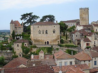
Puy-l'Évêque is a commune of France situated in the Lot department, in the Occitanie region. The town is picturesquely situated at the neck of a long loop of the Lot river in Quercy on the D811 between Fumel and Cahors, it is at the center of the Cahors (AOC) wine region.

<span class="mw-page-title-main">Capdenac</span> Commune in Occitania, France

Capdenac is a commune in the Lot department in south-western France.

<span class="mw-page-title-main">Ferrière-la-Grande</span> Commune in Hauts-de-France, France

Ferrière-la-Grande is a commune in the Nord department in northern France. The river Solre flows through the commune.

<span class="mw-page-title-main">Étrembières</span> Commune in Auvergne-Rhône-Alpes, France

Étrembières is a commune in the Haute-Savoie department in the Auvergne-Rhône-Alpes region in south-eastern France.

<span class="mw-page-title-main">Saint-Céré</span> Commune in Occitania, France

Saint-Céré is a commune in the Lot department, southern France. Its population is 3,414 (2019). The commune includes within its borders the castle of Saint-Laurent-les-Tours, where the artist Jean Lurçat lived and worked for many years, and from which he operated a secret radio for the French Resistance. The castle still houses a collection of his works.

<span class="mw-page-title-main">Sauveterre-la-Lémance</span> Commune in Nouvelle-Aquitaine, France

Sauveterre-la-Lémance is a commune in the Lot-et-Garonne department in south-western France.

<span class="mw-page-title-main">Tonneins</span> Commune in Nouvelle-Aquitaine, France

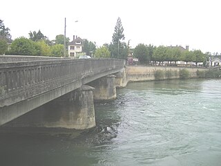
Tonneins is a town in the Lot-et-Garonne department of south-western France. It stands above the river Garonne, between Marmande to the west and Agen to the east, and is the first major town below the confluence of the Lot and Garonne Rivers after which the department is named. Tonneins station has rail connections to Agen, Langon and Bordeaux.

References

  1. "Populations légales 2020". The National Institute of Statistics and Economic Studies. 29 December 2022.
  2. Teneze, François (2008). Midi-Pyrénées. Petit Futé. p. 456. ISBN   9782746921146.
  3. Sauteron, François (2012). Le Quercy martyrisé: Occupation, Libération, retour des absents. Editions L'Harmattan. p. 109. ISBN   9782296497115.
  4. 1 2 Des villages de Cassini aux communes d'aujourd'hui: Commune data sheet Touzac, EHESS (in French).
  5. Population en historique depuis 1968, INSEE