This article needs additional citations for verification .(March 2015) (Learn how and when to remove this template message) |

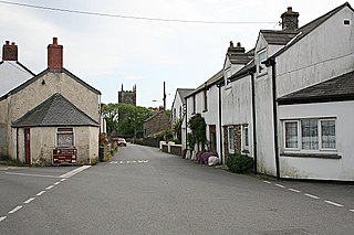
Trevoll is a hamlet in the parish of St Newlyn East, Cornwall, England, United Kingdom. [1]
St Newlyn East is a civil parish and village in Cornwall, England, United Kingdom. The village is approximately three miles (5 km) south of Newquay. The name St Newlyn East is locally abbreviated to Newlyn East and according to an anonymous historian writing in the Cornishman newspaper in 1880 it was only in recent years that Saint had been added to the parish name.
Cornwall is a ceremonial county in South West England, bordered to the north and west by the Celtic Sea, to the south by the English Channel, and to the east by Devon, the River Tamar forming the border between them. Cornwall is the westernmost part of the South West Peninsula of the island of Great Britain. The southwesternmost point is Land's End and the southernmost Lizard Point. Cornwall has a population of 563,600 and an area of 3,563 km2 (1,376 sq mi). The county has been administered since 2009 by the unitary authority, Cornwall Council. The ceremonial county of Cornwall also includes the Isles of Scilly, which are administered separately. The administrative centre of Cornwall is Truro, its only city.