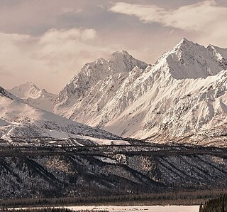
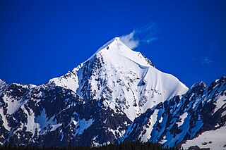
Awesome Peak is an 8,645-foot-elevation (2,635-meter) mountain summit located 35 miles (56 km) east-northeast of Palmer, in the northern Chugach Mountains of Alaska. This peak of the Matanuska Valley is set midway between Anchorage and Glennallen, near mile 90 of the Glenn Highway. It is situated 15 miles (24 km) west of Matanuska Glacier and 3.7 mi (6 km) southwest of Amulet Peak. Precipitation runoff from the mountain drains into Monument and Coal creeks, which are tributaries of the Matanuska River. Topographic relief is significant as the summit rises 5,650 feet above Coal Creek in 3.75 miles (6 km) and 4,650 feet above Monument Creek in 1.9 mile (3 km). This mountain's toponym has not been officially adopted by the United States Board on Geographic Names, so it is only marked as "8645" on USGS maps.
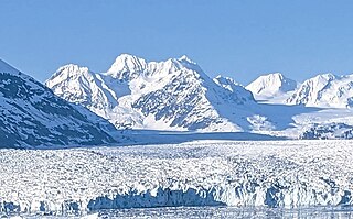
Tazcol Peak is a 7,850-foot-elevation (2,393-meter) mountain summit located 18 miles (29 km) north-northwest of Valdez in the U.S. state of Alaska. This remote glaciated mountain is set in the Chugach Mountains on land managed by Chugach National Forest. Precipitation runoff from the mountain drains south to Prince William Sound and north to Tazlina Lake → Tazlina River → Copper River. Topographic relief is significant as the summit rises 4,350 feet (1,326 m) above the East Branch of the Columbia Glacier in 1.4 mile (2.25 km). The peak's name was applied in 1959 by mountaineer and glaciologist Lawrence E. Nielsen (1917–1992), and the toponym was officially adopted in 1965 by the U.S. Board on Geographic Names. The word "Tazcol" is a portmanteau blending the names of the Tazlina Glacier and Columbia Glacier which flow from this mountain's north and south slopes respectively.
Mount Balchen is an 11,205-foot-elevation (3,415-meter) mountain summit in Alaska, United States.

Mount Gakona is a 9,865-foot-elevation (3,007-meter) mountain summit in Alaska.

Mount Dech is a 7,475-foot-elevation (2,278-meter) mountain summit in Alaska.

Tiehacker Mountain is a 4,435-foot-elevation (1,352-meter) mountain summit in Alaska, United States.
The Rowel is a 9,806-foot-elevation (2,989-meter) mountain summit in Alaska.

Mount Chichantna is a 10,893-foot-elevation (3,320-meter) mountain summit in Alaska.
Hearth Mountain is a 6,182-foot-elevation (1,884-meter) mountain summit in Alaska, United States.

Vigesimal Peak is a 6,550-foot-elevation (1,996-meter) mountain summit in Alaska, United States.

Alabaster Peak is an 8,065-foot-elevation (2,458-meter) mountain summit located 35 miles (56 km) east of Palmer, in the northern Chugach Mountains of Alaska. This peak of the Matanuska Valley is set midway between Anchorage and Glennallen, and can be seen from the Glenn Highway. It is situated 15 miles (24 km) west of Matanuska Glacier and 1.8 miles (2.9 km) south of Awesome Peak. Precipitation runoff from the mountain drains into Coal, Monument, and Gravel creeks, which are tributaries of the Matanuska River. Topographic relief is significant as the summit rises 3,065 feet along the west slope in one mile (1.6 km). The first ascent of the summit was made on July 4, 1970, by Robert Spurr, Bob Pelz, and Royce Purinton via the Spectrum Glacier and North Ridge. This mountain's toponym has not been officially adopted by the United States Board on Geographic Names, so it is only marked as "8065" on USGS maps.

Ragged Peak is a 9,160-foot (2,792 m) summit in Alaska, United States.
Government Peak is a 4,781-foot-elevation (1,457-meter) summit in Alaska, United States.

Bullion Mountain is a 5,086-foot-elevation (1,550-meter) summit in Alaska, United States.

Skyscraper Mountain is a 4,784-foot-elevation (1,458-meter) summit in Alaska, United States.

Troublemint Peak is a 6,801-foot-elevation (2,073-meter) summit in Alaska, United States.

Lynx Peak is a 6,536-foot-elevation (1,992-meter) summit in Alaska, United States.

Spearmint Spire is a 6,750-foot-elevation (2,057-meter) summit in Alaska, United States.

Higher Spire is a 6,135-foot-elevation (1,870-meter) summit in Alaska, United States.

Doublemint Peak is a 6,372-foot-elevation (1,942-meter) summit in Alaska, United States.


