
Hatcher Pass is a mountain pass through the southwest part of the Talkeetna Mountains, Alaska. It is named after Robert Hatcher, a prospector and miner. The nearest cities are Palmer and Wasilla approximately 12 miles (19 km) to the south, and Willow approximately 26 mi (42 km) to the west. The communities are at an elevation of approximately 250 ft (76 m) in the Mat-Su valley.

Tokosha Mountains is a 6,148 ft (1,870 m) multi-peak massif located in the Alaska Range, in Denali National Park and Preserve, in Alaska, United States. It is situated between the toes of Ruth Glacier and Tokositna Glacier, 27 mi (43 km) south-southeast of Denali and 26 mi (42 km) northwest of Talkeetna. Despite its relatively low elevation, it is notable for its Teton-esque granite spires which can be seen from the George Parks Highway. Precipitation runoff from the mountain drains into the Tokositna River → Chulitna River → Susitna River. Topographic relief is significant as the highest summit, Grand Tokosha, rises 3,850 feet above the Ruth Glacier in one mile (1.6 km).
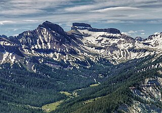
Coxcomb Peak is a 13,656-foot-elevation (4,162-meter) mountain summit located on the common boundary of Hinsdale County and Ouray County, in Colorado, United States. It is situated nine miles northeast of the community of Ouray, in the Uncompahgre Wilderness, on land managed by Uncompahgre National Forest. It is part of the San Juan Mountains which are a subset of the Rocky Mountains, and is situated west of the Continental Divide. Coxcomb ranks as the 171st-highest peak in Colorado, and topographic relief is significant as the south aspect rises 2,000 feet above Wetterhorn Basin in approximately one mile, and 4,400 feet above Cow Creek in three miles. Neighbors include Precipice Peak 2.7 miles to the north, Redcliff one-half mile north, Matterhorn Peak 2.3 miles to the east-southeast, and nearest higher neighbor Wetterhorn Peak 1.8 mile to the southeast. The mountain's descriptive name, which has been officially adopted by the United States Board on Geographic Names, was in use since at least 1906 when Henry Gannett published it in the Gazetteer of Colorado.
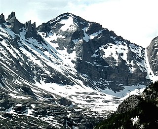
Pagoda Mountain is a 13,497-foot-elevation (4,114-meter) mountain summit in Boulder County, Colorado, United States.

Apache Peak is a 13,441-foot (4,097 m) mountain summit on the boundary shared by Boulder County and Grand County, in Colorado, United States.
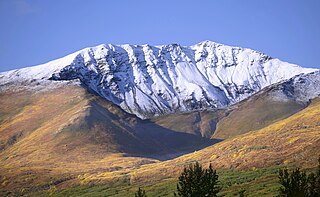
Mount Balchen is an 11,205-foot-elevation (3,415-meter) mountain summit in Alaska, United States.

Mount Yukla is a 7,569-foot (2,307 m) mountain summit in Alaska, United States.

Royal Tower is an 8,130-foot-elevation (2,478-meter) mountain summit in Alaska.
The Rowel is a 9,806-foot-elevation (2,989-meter) mountain summit in Alaska.

Mount Chichantna is a 10,893-foot-elevation (3,320-meter) mountain summit in Alaska.

Alabaster Peak is an 8,065-foot-elevation (2,458-meter) mountain summit located 35 miles (56 km) east of Palmer, in the northern Chugach Mountains of Alaska. This peak of the Matanuska Valley is set midway between Anchorage and Glennallen, and can be seen from the Glenn Highway. It is situated 15 miles (24 km) west of Matanuska Glacier and 1.8 miles (2.9 km) south of Awesome Peak. Precipitation runoff from the mountain drains into Coal, Monument, and Gravel creeks, which are tributaries of the Matanuska River. Topographic relief is significant as the summit rises 3,065 feet along the west slope in one mile (1.6 km). The first ascent of the summit was made on July 4, 1970, by Robert Spurr, Bob Pelz, and Royce Purinton via the Spectrum Glacier and North Ridge. This mountain's toponym has not been officially adopted by the United States Board on Geographic Names, so it is only marked as "8065" on USGS maps.

Ice Cream Cone Mountain is an 8,675-foot-elevation (2,644-meter) mountain summit located 22 miles (35 km) east of Palmer, in the northern Chugach Mountains of Alaska. This peak is visible from the Glenn Highway near Mile 70 west of Kings Mountain. Precipitation runoff from the mountain's north slope drains into Carpenter Creek, a tributary of the Matanuska River, whereas the south slope drains into Metal Creek, a tributary of the Knik River. Topographic relief is significant as the summit rises 5,200 feet above Metal Creek in 1.5 mile (2.4 km) and 5,675 feet above Carpenter Creek in 1.9 mile (3 km). The first ascent of the summit was made on July 3, 1967, by David P. Johnston, John Samuelson, and Hans Van der Laan via the Northeast Ridge. This mountain's local descriptive toponym has not been officially adopted by the United States Board on Geographic Names, so it is only marked as "8675" on USGS maps. Some climbers in Anchorage call this peak the "Sky Buster" which was the name applied by mountaineer Vin Hoeman.
Government Peak is a 4,781-foot-elevation (1,457-meter) summit in Alaska, United States.

Bullion Mountain is a 5,086-foot-elevation (1,550-meter) summit in Alaska, United States.

Skyscraper Mountain is a 4,784-foot-elevation (1,458-meter) summit in Alaska, United States.

Triplemint Peak is a 6,332-foot-elevation (1,930-meter) summit in Alaska, United States.

Lynx Peak is a 6,536-foot-elevation (1,992-meter) summit in Alaska, United States.

Spearmint Spire is a 6,750-foot-elevation (2,057-meter) summit in Alaska, United States.

Higher Spire is a 6,135-foot-elevation (1,870-meter) summit in Alaska, United States.

Doublemint Peak is a 6,372-foot-elevation (1,942-meter) summit in Alaska, United States.


