Lynx Peak | |
---|---|
![]() West aspect | |
Highest point | |
Elevation | 6,536 ft (1,992 m) [1] [2] |
Prominence | 736 ft (224 m) [2] |
Parent peak | Montana Peak (6,950 ft) [3] |
Isolation | 1.71 mi (2.75 km) [2] |
Coordinates | 61°51′08″N149°07′14″W / 61.852332°N 149.120564°W [2] |
Naming | |
Etymology | Lynx |
Geography | |
Country | United States |
State | Alaska |
Borough | Matanuska-Susitna |
Protected area | Hatcher Pass Management Area |
Parent range | Talkeetna Mountains [2] |
Topo map | USGS Anchorage D-6 |
Lynx Peak is a 6,536-foot-elevation (1,992-meter) summit in Alaska, United States.
Lynx Peak is located 20 miles (32 km) north of Palmer, Alaska, in the Talkeetna Mountains and in the Hatcher Pass Management Area of the state park system. Precipitation runoff from this mountain's south slope drains into headwaters of the Little Susitna River, whereas the west side drains to Reed Creek which flows to the Little Susitna, and the north slope drains to Bartholf Creek which is a tributary of the Kashwitna River. Topographic relief is significant as the summit rises 3,550 feet (1,082 meters) above the Little Susitna River in 1.5 miles (2.4 km). The nearest higher neighbor is Troublemint Peak 2.58 miles (4.15 km) to the east. [2] The approach to the peak is via the 4.3-mile-long Reed Lakes Trail. On November 15, 1957, a B-29 Superfortress crashed in bad weather about 800 feet below the summit of Lynx Peak on the Bomber Glacier, killing six of the ten people aboard. [4] The crash site is a hiking destination with wreckage still present. [5] This mountain's toponym has not been officially adopted by the United States Board on Geographic Names.
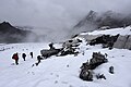
Based on the Köppen climate classification, Lynx Peak is located in a subarctic climate zone with long, cold, snowy winters, and short cool summers. [6] Winter temperatures can drop below 0 °F with wind chill factors below −10 °F. This climate supports the Bomber Glacier on the north slope. The months of May through June offer the most favorable weather for climbing or viewing. [7]
Hatcher Pass is a mountain pass through the southwest part of the Talkeetna Mountains, Alaska. It is named after Robert Hatcher, a prospector and miner. The nearest cities are Palmer and Wasilla approximately 12 miles (19 km) to the south, and Willow approximately 26 mi (42 km) to the west. The communities are at an elevation of approximately 250 ft (76 m) in the Mat-Su valley.
The Talkeetna Mountains are a mountain range in Alaska. The Matanuska and Susitna River valleys, with towns such as Trapper Creek, Talkeetna, Wasilla, Palmer, Sutton, and Chickaloon, roughly bound the Talkeetnas in the westerly parts of the range. Sovereign Mountain rises to 8,849 feet (2,697 m) in the remote and heavily glaciated central part of the range. The east side of the range fronts a broad, about 100 miles (160 km) wide, lake-studded lowland of forests and swamps, across which rises the gigantic Mount Wrangell volcanic edifice. Alaska Highway 4 runs northward through this lowland. Hundreds of miles to the west Alaska Highway 3 runs along the western side of the Talkeetna range, with the Alaska Range directly west. Alaska Highway 1, running along the southern front of the Talkeetna Mountains, lies mainly in a valley marking a tectonic divide between the Jurassic and Cretaceous rocks of the accretionary wedge, island-arc, and basement rocks in the Peninsular terrane, and the Chugach Mountains in the Chugach terrane to the south. The range stretches as much as a hundred miles north to south. Alaska Highway 8, seasonal and unpaved, passes over highlands rising to above 4,000 feet (1,200 m), north of the Talkeetnas.
Tokosha Mountains is a 6,148 ft (1,870 m) multi-peak massif located in the Alaska Range, in Denali National Park and Preserve, in Alaska, United States. It is situated between the toes of Ruth Glacier and Tokositna Glacier, 27 mi (43 km) south-southeast of Denali and 26 mi (42 km) northwest of Talkeetna. Despite its relatively low elevation, it is notable for its Teton-esque granite spires which can be seen from the George Parks Highway. Precipitation runoff from the mountain drains into the Tokositna River → Chulitna River → Susitna River. Topographic relief is significant as the highest summit, Grand Tokosha, rises 3,850 feet above the Ruth Glacier in one mile (1.6 km).
Scott Peak is an 8,828 ft (2,690 m) glaciated mountain summit located in Denali National Park and Preserve, on the crest of the Alaska Range, in the U.S. state of Alaska. It is situated 9 mi (14 km) southeast of the Eielson Visitor Center, at the head of the Sunset Glacier, and 33.5 mi (54 km) northeast of Denali. This mountain was named in 1953 by Reynold E. (Pete) Isto of the U.S. Geological Survey and Bradford Washburn to honor Lieutenant Gordon D. Scott (1925–1953), a surveyor for the United States Coast and Geodetic Survey who was killed in a plane crash during mapping operations of this area. Scott Peak is set ten miles south of where the crash occurred near the Stony Creek Bridge area of the park road on June 11, 1953. Established climbing routes on Scott Peak include the Northeast Face, Northwest Face, and the Sunset Glacier. The first ascent of this peak was made in 1953 by Bradford Washburn.
Apache Peak is a 13,441-foot (4,097 m) mountain summit on the boundary shared by Boulder County and Grand County, in Colorado, United States.
Navajo Peak is a 13,409-foot (4,087 m) mountain summit on the boundary shared by Boulder County and Grand County, in Colorado, United States.
Mount Balchen is an 11,205-foot-elevation (3,415-meter) mountain summit in Alaska, United States.
Tiehacker Mountain is a 4,435-foot-elevation (1,352-meter) mountain summit in Alaska, United States.
Royal Tower is an 8,130-foot-elevation (2,478-meter) mountain summit in Alaska.
Hearth Mountain is a 6,182-foot-elevation (1,884-meter) mountain summit in Alaska, United States.
Paradise Peak is a 6,050-foot-elevation (1,844-meter) mountain summit in Alaska, United States.
Vigesimal Peak is a 6,550-foot-elevation (1,996-meter) mountain summit in Alaska, United States.
Government Peak is a 4,781-foot-elevation (1,457-meter) summit in Alaska, United States.
Bullion Mountain is a 5,086-foot-elevation (1,550-meter) summit in Alaska, United States.
Skyscraper Mountain is a 4,784-foot-elevation (1,458-meter) summit in Alaska, United States.
Troublemint Peak is a 6,801-foot-elevation (2,073-meter) summit in Alaska, United States.
Triplemint Peak is a 6,332-foot-elevation (1,930-meter) summit in Alaska, United States.
Spearmint Spire is a 6,750-foot-elevation (2,057-meter) summit in Alaska, United States.
Higher Spire is a 6,135-foot-elevation (1,870-meter) summit in Alaska, United States.
Doublemint Peak is a 6,372-foot-elevation (1,942-meter) summit in Alaska, United States.