Trondheim Toll Scheme or Trondheim Package (Norwegian: Trondheimspakken) was the result of that in the 1980s politicians and road authorities in Trondheim, Norway wanted to accelerate the investments in roads and motorways around the city through an investment package and toll scheme to ease construction and generate more funds. Between 1991 and 2005 there were more than 20 toll plazas throughout the city that help finance the new roads. Toll plazas will still remain east of the city at least until 2012. The toll collection is administrated by Trøndelag Veifinans.
A politician is a person active in party politics, or a person holding or seeking office in government. Politicians propose, support and create laws or policies that govern the land and, by extension, its people. Broadly speaking, a "politician" can be anyone who seeks to achieve political power in any bureaucratic institution.
Trondheim is a city and municipality in Trøndelag county, Norway. It has a population of 193,501, and is the third-most populous municipality in Norway, although the fourth largest urban area. Trondheim lies on the south shore of Trondheim Fjord at the mouth of the River Nidelva. The city is dominated by the Norwegian University of Science and Technology (NTNU), the Foundation for Scientific and Industrial Research (SINTEF), St. Olavs University Hospital and other technology-oriented institutions.
Norway, officially the Kingdom of Norway, is a Nordic country in Northwestern Europe whose territory comprises the western and northernmost portion of the Scandinavian Peninsula; the remote island of Jan Mayen and the archipelago of Svalbard are also part of the Kingdom of Norway. The Antarctic Peter I Island and the sub-Antarctic Bouvet Island are dependent territories and thus not considered part of the kingdom. Norway also lays claim to a section of Antarctica known as Queen Maud Land.
The system financed by the scheme includes a ring road around the city on European route E6, a new motorway east of the city to Stjørdal and Trondheim Airport, Værnes on E6, upgrades to E6 south of the city, including a new intersection at Sandmoen, a new Kroppan Bridge and a four-lane motorway between Klett and Melhus. As of 2007[update] a road from Ila via Brattøra to Lademoen, named Nordre Avlastningsvei, is under construction with plans to be finished in 2009 while an extension of E6 between the airport and to Kvithamar north of Stjørdal is in the start phase. Projects still not started include putting Osloveien in Byåsen in a tunnel, a new Sluppen Bridge and a four-lane motorway between Tonstad in Tiller to Klett in Leinstrand. There was also a political consensus that some of the money generated by the system should be used to improve public transport in the city. Some environmental projects in the area also benefit from the toll income.
European route E6 is the main north-south road through Norway, and the west coast of Sweden. It is 3 088 km long and runs from the southern tip of Sweden at Trelleborg, into Norway and through almost all of the country north to the Arctic Circle and Nordkapp. The route ends in Kirkenes close to the Russian border.
Stjørdal or Skierde is a municipality in Trøndelag county, Norway. It is part of the Stjørdalen region. The administrative centre of the municipality is the town of Stjørdal, also called Stjørdalshalsen. Some of the villages in the municipality include Elvran, Flornes, Hegra, Hell, Kvithammer, Prestmoen, Skatval, Skjelstadmarka, Sona, and Værnes.
Trondheim Airport, Værnes is an international airport serving Trondheim, a city and municipality in Trøndelag county, Norway. The airport is located in Værnes, a village in the municipality of Stjørdal in Trøndelag county, 10 nautical miles east of Trondheim. Operated by the state-owned Avinor, it shares facilities with Værnes Air Station of the Royal Norwegian Air Force. In 2014, the airport had 4,416,681 passengers and 60,934 air movements, making it the fourth-busiest in the country. The airport has two terminals; A dates from 1994 and is used for domestic traffic, while B is the renovated former main terminal from 1982, and is used for international traffic. The airport features a main east–west 2,999-metre (9,839 ft) runway, a disused northwest–southeast 1,472-metre (4,829 ft) runway, an integrated railway station and an airport hotel.
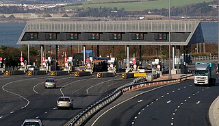
More than twenty toll booths were built, closing off all approaches to the city. It was impossible for anybody driving a car to get in for free weekdays between 6am and 6pm. The charge was NOK 15 for cars and 30 for trucks. The systems has been designed to be user friendly through AutoPASS technology developed by the local company Q-Free, involving a radio-transmitted registration of passing cars, allowing cars to pass the toll booths at 60km/h (but at most toll booths the speed limit was 50km/h). All the driver need to do is fit a little plastic device to the windscreen of the car. This communicates with the toll booth when the car passes through, deducting money from the user's account. Those who (intentionally or by negligence) passes a toll booth without an operating toll device (or paying manually where possible) are subject to a fine. Motorists using a toll device are eligible to a toll discount.
The krone[ˈkruːnə], plural kroner, is the currency of Norway and its dependent territories. It is subdivided into 100 øre, which have existed only electronically since 2012. The name translates into English as crown.
Autopass is an electronic toll collection system used in Norway. It allows collecting road tolls automatically from cars. It uses electronic radio transmitters and receivers operating at 5.8 GHz (MD5885) originally supplied by the Norwegian companies Q-Free and Fenrits. Since 2013 Kapsch and Norbit supplied the transponders. In 2016 the Norwegian Public Roads Administration revealed that they had chosen Norbit and Q-Free as suppliers of Autopass-transponders the next four years.
The toll ring was not juridically considered a road pricing scheme, since the income from the tolls goes to road infrastructure. To be considered a road pricing in accordance to Norwegian law the scheme must be organised such as to charge most when the congestion is largest, i.e. in rush hour. Secondly a road pricing scheme cannot primarily finance road investments, but must go either to public transport subsidies or to infrastructure for public transport and pedestrians and bicycles.
Road pricing are direct charges levied for the use of roads, including road tolls, distance or time based fees, congestion charges and charges designed to discourage use of certain classes of vehicle, fuel sources or more polluting vehicles. These charges may be used primarily for revenue generation, usually for road infrastructure financing, or as a transportation demand management tool to reduce peak hour travel and the associated traffic congestion or other social and environmental negative externalities associated with road travel such as air pollution, greenhouse gas emissions, visual intrusion, noise and road accidents.
The law of Norway can be regarded as a hierarchy of norms. The highest level is the same Constitution of 17 May 1814. Statutes made under the Constitution are subordinate to it. Regulations made under such a statute are subordinate to such law.
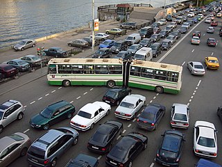
Traffic congestion is a condition on transport networks that occurs as use increases, and is characterised by slower speeds, longer trip times, and increased vehicular queueing. When traffic demand is great enough that the interaction between vehicles slows the speed of the traffic stream, this results in some congestion. While congestion is a possibility for any mode of transportation, this article will focus on automobile congestion on public roads.
The system was initially introduced to fund the building of new ring roads so that the heaviest traffic would not have to pass through the city centre. But part of the reason for this traffic is that Trondheim Port is located on an artificial island only accessible via the city centre and Trondheim has yet to do like most cities and move its port out of the city centre, like the London Docklands and Fjordbyen in Oslo. There are ongoing discussions on whether the port should be moved from its current location. The lack of a bypass outside the residential areas, along with less than optimal railroad capacity; also contributes to the heavy road traffic through the municipality.
Midtbyen is a borough of the city of Trondheim in Trøndelag county, Norway. The borough comprises much of the city centre of downtown Trondheim plus part of the Bymarka rural areas to the west.
A port is a maritime commercial facility which may comprise one or more wharves where ships may dock to load and discharge passengers and cargo. Although usually situated on a sea coast or estuary, some ports, such as Hamburg, Manchester and Duluth, are many miles inland, with access from the sea via river or canal.
London Docklands is the riverfront and former docks in London. In east and southeast London, it forms part of the boroughs of Southwark, Tower Hamlets, Lewisham, Newham, and Greenwich. The docks were formerly part of the Port of London, at one time the world's largest port. Following the closure of the docks, the area became derelict and poverty-ridden by the 1980s. The Docklands' regeneration began later that decade; it has been redeveloped principally for commercial and residential use. The name "London Docklands" was used for the first time in a government report on redevelopment plans in 1971 and has since become virtually universally adopted. The redevelopment created wealth, but also led to conflict between the new and old communities in the areas thus designated.
Criticism
The initial reaction to the toll system in Trondheim was mixed. Some daily commuters felt the extra cost was unjustifiable, but most drivers were quite happy to pay in order to get some of the heaviest traffic out of the city centre. Ten years on, most drivers in and around Trondheim do not give the toll system a second thought. They have become used to it over time, and the system was also cleverly designed to be extremely user-friendly [citation needed].
The initial development of the project came at the same time as the city council decided to close the Trondheim Tramway in 1988, with arguments that diesel buses are cheaper to operate. Trondheim has a notoriously low public transport ridership, at 11% of the total transport trips using public transport, compared to almost 50% in Oslo. Part of this is credited the low frequency and high time costs of using public transport in Trondheim, partially due to high investments in road infrastructure compared to public transport infrastructure.
After the toll ring was closed in 2005 some politicians, environmental advocates and others have suggested reintroducing the toll ring. While some are wanting to use the funds to complete the Trondheim Package, others are wanting to use it to reduce traffic congestion and use the funds for public transport subsidies.
This page is based on this Wikipedia article Text is available under the CC BY-SA 4.0 license; additional terms may apply. Images, videos and audio are available under their respective licenses.
Related Research Articles
Transport in Norway is highly influenced by Norway's low population density, narrow shape and long coastline. Norway has old water transport traditions, but road, rail and air transport have increased in importance during the 20th century. Due to the low population density, public transport is somewhat less built out in rural areas of Norway, however public transport in, and around cities is well developed.
The Dartford-Thurrock River Crossing, commonly known as the Dartford Crossing and until 1991 the Dartford Tunnel, is a major road crossing of the River Thames in England, carrying the A282 road between Dartford in Kent to the south with Thurrock in Essex to the north. It consists of two bored tunnels and the cable-stayed Queen Elizabeth II Bridge. The only fixed road crossing of the Thames east of Greater London, it is the busiest estuarial crossing in the United Kingdom, with an average daily use of over 130,000 vehicles. It opened in stages: the west tunnel in 1963, the east tunnel in 1980 and the bridge in 1991. The crossing, although not officially designated a motorway, is considered part of the M25 motorway's route, using the tunnels northbound and bridge southbound. Described as one of the most important road crossings in Britain, it suffers from heavy traffic and congestion.
A toll road, also known as a turnpike or tollway, is a public or private road for which a fee is assessed for passage. It is a form of road pricing typically implemented to help recoup the cost of road construction and maintenance.
An intelligent transportation system (ITS) is an advanced application which, without embodying intelligence as such, aims to provide innovative services relating to different modes of transport and traffic management and enable users to be better informed and make safer, more coordinated, and 'smarter' use of transport networks.
Congestion pricing or congestion charges is a system of surcharging users of public goods that are subject to congestion through excess demand such as higher peak charges for use of bus services, electricity, metros, railways, telephones, and road pricing to reduce traffic congestion; airlines and shipping companies may be charged higher fees for slots at airports and through canals at busy times. This pricing strategy regulates demand, making it possible to manage congestion without increasing supply.
Electronic toll collection (ETC) aims to eliminate the delay on toll roads, HOV lanes, toll bridges, and toll tunnels by collecting tolls without cash and without requiring cars to stop. Electronic toll booths may operate alongside cash lanes so that drivers who do not have transponders can pay a cashier or throw coins into a receptacle. With cashless tolling, cars without transponders are either excluded or pay by plate – a bill may be mailed to the address where the car's license plate number is registered, or drivers may have a certain amount of time to pay with a credit card by phone. Open road tolling is a popular form of cashless tolling without toll booths; cars pass electronic readers even at highway speeds without the safety hazard and traffic bottlenecks created by having to slow down to go through an automated toll booth lane.
The M6 Toll, also called the Birmingham North Relief Road (BNRR), connects M6 Junction 3a at the Coleshill Interchange to M6 Junction 11A at Wolverhampton with 27 miles (43 km) of six-lane motorway.
Highways in Poland are public roads designed to carry large amounts of traffic. The public roads in Poland are grouped into four categories related to the republic's administrative division. Motorways and expressways are part of the national road (DK) network. Voivodeship roads (DW) are provincial-level roads administered by the individual governments of the voivodeships. Powiat and gmina roads are administered by county and municipal authorities, and do not have any separate road signs for them, though they do have their respective signature. Poland has 419,636.4 km (260,750 mi) of public roads, of which 128,713.3 km (79,979 mi) are unsurfaced (2015):
The Roads & Traffic Authority (RTA) is a former Australian government agency in New South Wales that was responsible for major road infrastructure, licensing of drivers, and registration of motor vehicles. The RTA directly managed State roads and provided funding to local councils for regional and local roads. In addition, with assistance from the Federal Government, the RTA also previously managed the NSW national highway system. The agency was abolished in 2011 and replaced by NSW Roads and Maritime Services.
The United Kingdom has a network of roads, of varied quality and capacity, totalling about 262,300 miles (422,100 km). Road distances are shown in miles or yards and UK speed limits are indicated in miles per hour (mph) or by the use of the national speed limit (NSL) symbol. Some vehicle categories have various lower maximum limits enforced by speed limiters. Enforcement of UK road speed limits increasingly uses speed guns, automated in-vehicle systems and automated roadside traffic cameras. A unified numbering system is in place for Great Britain, whilst in Northern Ireland, there is no available explanation for the allocation of road numbers.
The M2 Hills Motorway is a tollway in north-western Sydney, Australia, owned by toll road operator Transurban. It forms part of Sydney's M2 route and the 110 km Sydney Orbital Network. West of Pennant Hills Road, the M2 is also part of the National Highway.
A toll road is a road over which users may travel over on payment of a toll, or fee. Tolls are a form of user tax that pays for the cost of road construction and maintenance, without raising taxes on non-users. Investor's bonds necessary for the construction of the roads are issued and sold with the expectation that the bonds will be paid back with user tolls. The toll roads may be run by government agencies that have bond issuing authority and/or private companies that sell bonds or have other sources of finance. Toll roads are usually a government guaranteed road monopoly that guarantees limited or no competing roads will be built by government agencies for the duration of the bonds. Private toll roads built with money raised from private investors in expectation of making money from the tolls probably dominated early toll roads. Government sponsored toll roads often guarantee a minimum payment to the bond holders if traffic volume and toll collections are less than predicted. If the toll authority is a private company there is often a maximum amount of fees that they may extract from users. Toll road operators are typically responsible for maintaining the roads. After the bonds are paid off the road typically reverts to the government agency that authorized the road and owns the land it was built on. Like most government taxes it is not unusual for tolls to continue to be charged after the bonds have been paid off.
A High-quality dual carriageway (HQDC) is a category of road in Ireland. It is an all-purpose dual carriageway road type built to near motorway standards, but without motorway classification or motorway restrictions. High-quality dual carriageways have full grade-separated access and do not have junctions with minor roads. Such roads in the Republic of Ireland have been built as part of the 2000-2006 and 2007-2013 National Development Plans, including interurban routes from Dublin to other cities.
Germany's LKW-Maut is a toll for goods vehicles based on the distance driven in kilometres, the emission category of the vehicle and the number of axles.
The M8 motorway is an inter-urban motorway in Ireland, which forms part of the motorway from the capital Dublin to Cork city. The 149 km motorway commences in the townland of Aghaboe, County Laois and runs through the counties of Kilkenny, Tipperary and Limerick, terminating at the Dunkettle interchange in County Cork.
First called for in the Road Needs Study (1998), it was later incorporated into the National Development Plan (2000–2006) and later still formed part of the Irish Government's Transport 21 plan for infrastructural development. The majority of the M8 (115 km) was built between 2006 and 2010. On 28 May 2010, the motorway was completed and had replaced almost all of the single-carriageway N8 except for a short section of urban road in Cork City.
The Oslo Package 2 or O2 is a political agreement for financing investments in public transport in Oslo and Akershus, Norway. The program runs from 2001 to 2011, and includes many large and small investments in railways, the Oslo Tramway, the Oslo Metro and infrastructure for buses. Total budget is 15.6 billion kr. The project is a cooperation between the transit authorities Oslo Sporveier and Stor-Oslo Lokaltrafikk, Oslo Municipality and Akershus County Municipality, and the government agencies of the Norwegian National Rail Administration and the Norwegian Public Roads Administration.
Oslo Package 1 was a political agreement and plan for introducing an urban toll ring around Oslo, Norway, and making 31 investments to road infrastructure in Oslo and Akershus. The package was approved in 1988, and toll charges were introduced in 1990. It was supplemented by Oslo Package 2, which included a similar scheme for public transport. In 2008, they were both replaced by Oslo Package 3.
Cycling infrastructure refers to all infrastructure which may be used by cyclists. This includes the same network of roads and streets used by motorists, except those roads from which cyclists have been banned, plus additional bikeways that are not available to motor vehicles, such as bike paths, bike lanes, cycle tracks and, where permitted, sidewalks, plus amenities like bike racks for parking and specialized traffic signs and signals. Cycling modal share is strongly associated with the size of local cycling infrastructure.