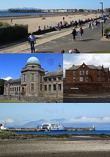
Bathgate railway station was a railway station serving the town of Bathgate in West Lothian, Scotland. It was located at the western end of the Edinburgh-Bathgate Line. The station was 18½ miles (30 km) west of Edinburgh.

Dalry railway station is a railway station serving the town of Dalry, Ayrshire, Scotland. The station is managed by Abellio ScotRail and is on the Ayrshire Coast Line.

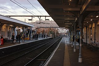
Barassie railway station is a railway station serving Barassie, South Ayrshire, Scotland. The station is managed by Abellio ScotRail and is on the Ayrshire Coast Line.
Rochford railway station is on the Shenfield to Southend Line in the East of England, serving the town of Rochford, Essex. It is 38 miles 54 chains (62.24 km) down the line from London Liverpool Street and is situated between Hockley and Southend Airport stations. The Engineer's Line Reference for the line is SSV; the station's three-letter station code is RFD. The platforms have an operational length for 12-coach trains.

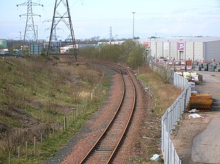
Arkleston Junction is a railway junction east of the town of Paisley, Renfrewshire, Scotland. The junction is one mile from Paisley Gilmour Street railway station and is heavily used by both passenger and freight traffic.
The Glasgow and Paisley Joint Railway was the section of railway line between Glasgow Bridge Street railway station and Paisley, in the west of Scotland. It was constructed and operated jointly by two competing railway companies as the stem of their lines to Greenock and Ayr respectively, and it opened in 1840. The Joint Committee, which controlled the line, built a branch to Govan and later to Cessnock Dock, and then Prince's Dock.

Crosshouse railway station was a railway station serving the village of Knockentiber and nearby Crosshouse, East Ayrshire, Scotland. The station was originally part of the Glasgow, Paisley, Kilmarnock and Ayr Railway.
Troon railway station was a railway station serving the town of Troon, South Ayrshire, Scotland. Located at Troon Harbour, this was the first railway station in the town and was part of the Kilmarnock and Troon Railway.
Drybridge is a village in North Ayrshire, Scotland. Drybridge is thus named because of the "dry bridge" over the Kilmarnock and Troon Railway, opened in 1812. The nearby "wet bridge" is the Laigh Milton Viaduct, the oldest surviving railway bridge in Scotland and possibly the world.
Mauchline railway station was a railway station serving the town of Mauchline, East Ayrshire, Scotland. The station was originally part of the Glasgow, Paisley, Kilmarnock and Ayr Railway.

Hurlford railway station was a railway station serving the village of Hurlford, East Ayrshire, Scotland. The station was originally part of the Glasgow, Paisley, Kilmarnock and Ayr Railway.

Long Ashton railway station was a railway station on the Bristol to Exeter Line, 3.5 miles (5.6 km) southwest of Bristol Temple Meads, serving the village of Long Ashton in North Somerset, England. There were two stations on the site, the first, called "Ashton", opened in either 1841 or 1852 and closed in 1856. The second station, originally known as "Long Ashton Platform" before being renamed as "Long Ashton" in 1929, was operational from 1926 to 1941. The site is now partly under the A370 Long Ashton Bypass, and there are no visible remains of the station. There is local support for the station to be reopened, possibly sited further to the west, and possibly as part of the University of Bristol's proposed Fenswood Farm development.

Lydd Town was a railway station which served the town of Lydd in Kent, England. Opened on 7 December 1881 by The Lydd Railway Company. It closed to passengers in 1967 but the line through the station remained open for freight.
Thornhill is a closed station. It served the country town of Thornhill in Dumfries and Galloway. The station site is a mile or so from the town. Four miles north of Thornhill is Drumlanrig Castle, home to the Duke of Buccleuch and Queensberry. The Glasgow and South Western main line rail route between Kilmarnock and Dumfries is forced to make a long detour to the east of Thornhill and through a long tunnel, rather than the more logical route nearer Thornhill town centre and up the Nith Valley, so as not to be seen from the Buccleuch estate. The distance of the station from Thornhill may be one reason that passenger use was light and stopping services ended in 1965. There was formerly a busy livestock market near to the station, which eventually closed around 2001.
Riccarton and Craigie was a railway station serving the village of Riccarton and the distant hamlet of Craigie, both in East Ayrshire, Scotland. Originally just called Riccarton, it was renamed in 1905.

Widmerpool was a railway station serving Widmerpool in the English county of Nottinghamshire. It was situated on the Midland Railway route between London and Nottingham via Corby.
Loudounhill was a railway station on the Darvel and Strathaven Railway serving a rural area that included the landmark of Loudoun Hill in the Parish of Galston, East Ayrshire, Scotland.

Drumclog was a railway station on the Darvel and Strathaven Railway serving a rural area that included the village of Drumclog in South Lanarkshire, Scotland.

Girvan Old railway station was a terminus station opened in Girvan by the Maybole and Girvan Railway and although ambitions existed to extend the line through to Stranraer it was built on a site that would not permit this and so when the line was built the Girvan New station was opened on 5 October 1877 by the Girvan and Portpatrick Junction Railway on the route to Pinmore and eventually through to Stranraer railway station.