Trostrey

Last updated

Trostrey
St Davids Church, Trostrey - 1282666 - geograph.org.uk.jpg
St David's Church
Monmouthshire UK location map.svg
Red pog.svg
Trostrey
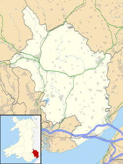
Location within Monmouthshire
OS grid reference SO 360 044
Principal area
Ceremonial county
Country Wales
Sovereign state United Kingdom
Post town USK
Postcode district NP15
Dialling code 01291
Police Gwent
Fire South Wales
Ambulance Welsh
UK Parliament
List of places
UK
Wales
Monmouthshire
51°44′03″N2°55′42″W / 51.73423°N 2.9284°W / 51.73423; -2.9284 Coordinates: 51°44′03″N2°55′42″W / 51.73423°N 2.9284°W / 51.73423; -2.9284

Trostrey (Welsh : Trostre) is a small hamlet and parish in Monmouthshire, in southeast Wales located about 2+12 miles (4.0 km) north/northwest of Usk.
Contents

History

Excavations at the castle in 2000 found evidence of burial cairns from the Neolithic and Bronze Age periods. [1] An 11th-century earthen motte-and-bailey castle was replaced in the 13th century by a small stone fort. [2] A manor house, Trostrey Court stands 12 mile (0.80 km) east of the village. [2] The Church of St David is dedicated to St David. [2]

Notes

  1. "TROSTREY CASTLE EXCAVATIONS - Coflein". www.coflein.gov.uk.
  2. 1 2 3 Newman 2000, pp. 582–3.

Related Research Articles

<span class="mw-page-title-main">Usk</span> Town in Monmouthshire, Wales

Usk is a town and community in Monmouthshire, Wales, 10 miles (16 km) northeast of Newport. It is located on the River Usk, which is spanned by an arched stone bridge at the western entrance to the town. Usk Castle, above the town, overlooks the ancient crossing point. It developed as a small market town, with some industry including the making of Japanware, and with a notable prison built in 1841/2. In recent years Usk has become known for its history of success in Britain in Bloom competitions, winning the Large Village award in 2005. The resident population of the town in 2001 was 2,318, increasing to 2,834 at the 2011 census.

<span class="mw-page-title-main">Trellech</span> Human settlement in Wales

Trellech is a village and parish in Monmouthshire, south-east Wales. Located 5 miles (8 km) south of Monmouth and 4 miles (6.4 km) north-north-west of Tintern, Trellech lies on a plateau above the Wye Valley on the southern fringes of 320 acres (130 ha) of woodland in an Area of Outstanding Natural Beauty. Three Bronze Age standing stones are situated in the village, known as Harold's Stones, which overlook the historic church of St Nicholas, a Grade I listed building.

<span class="mw-page-title-main">Llanvair Discoed</span> Human settlement in Wales

Llanvair Discoed is a small village in Monmouthshire, south-east Wales, 6 miles west of Chepstow and 10 miles east of Newport.

<span class="mw-page-title-main">Raglan, Monmouthshire</span> Village in Monmouthshire, Wales

Raglan (; is a village and community in Monmouthshire, south east Wales, United Kingdom. It is located some 9 miles south-west of Monmouth, midway between Monmouth and Abergavenny on the A40 road very near to the junction with the A449 road. The fame of the village derives from Raglan Castle, built for William ap Thomas and now maintained by Cadw. The community includes the villages of Llandenny and Pen-y-clawdd. Raglan itself has a population of 1,183.

<span class="mw-page-title-main">Llangybi, Monmouthshire</span> Human settlement in Wales

Llangybi is a village and community in Monmouthshire, in southeast Wales, in the United Kingdom. It is located 3 miles (4.8 km) south of the town of Usk and 5 miles (8 km) north of Caerleon, in the valley of the River Usk.

<span class="mw-page-title-main">Cwmcarvan</span> Human settlement in Wales

Cwmcarvan is a small rural village in Monmouthshire, south east Wales. It is located 4 miles south west of Monmouth and about 4 miles east of Raglan, off the old A40 road two miles NW of Trellech.

<span class="mw-page-title-main">Tredunnock</span> Human settlement in Wales

Tredunnock is a small village in Monmouthshire, south east Wales, in the United Kingdom. Tredunnock is located four miles (6.4 km) northeast of Caerleon and four miles south of Usk.

<span class="mw-page-title-main">Llangwm, Monmouthshire</span> Human settlement in Wales

Llangwm is a small rural village and former community, now in the community of Llantrisant Fawr, in Monmouthshire, south east Wales. It is located 3 miles (4.8 km) east of Usk, on the B4235 Chepstow to Usk road. The main village is at Llangwm Uchaf, with a smaller and more dispersed settlement about 1 mile (1.6 km) to the north-east at Llangwm Isaf .The other settlement in the community is Llansoy. In 2022 the community was abolished and merged with Llantrisant Fawr.

<span class="mw-page-title-main">Dixton</span> Human settlement in Wales

Dixton is a small village located 1 mile (1.6 km) north east of Monmouth, on the banks of the River Wye, in Monmouthshire, south east Wales. The parish originally comprised the two manors of Dixton Newton and Dixton Hadnock, on either side of the river.

<span class="mw-page-title-main">Pen-y-clawdd</span> Human settlement in Wales

Pen-y-clawdd is a village in Monmouthshire, south east Wales, situated between Raglan and Monmouth. The village is the site of a medieval fortification and there is a historic church with an ancient cross in the churchyard which is a scheduled monument.

<span class="mw-page-title-main">Clytha Park</span> House in Clytha, Monmouthshire

Clytha Park, Clytha, Monmouthshire, is a 19th-century Neoclassical country house, "the finest early nineteenth century Greek Revival house in the county." The wider estate encompasses Monmouthshire's "two outstanding examples of late eighteenth century Gothic", the gates to the park and Clytha Castle. The owners were the Jones family, later Herbert, of Treowen and Llanarth Court. It is a Grade I listed building.

<span class="mw-page-title-main">Llanvihangel Court</span> Tudor country house in Llavihangel Crucorney, Monmouthshire, Wales

LlanvihangelCourt, Llanvihangel Crucorney, is a Tudor country house in Monmouthshire, Wales. The architectural historian John Newman, in his Gwent/Monmouthshire volume of The Buildings of Wales series described the court as "the most impressive and richly decorated house of around 1600 in Monmouthshire". The origins of the house are medieval, with a traditional date of construction of 1471. The building was given its present appearance by a substantial enlargement and re-casing of circa 1600 by Rhys Morgan, of the family of the original owners. In the very early 17th century it was owned briefly by Edward Somerset, 4th Earl of Worcester.

<span class="mw-page-title-main">Castle House, Usk</span> House in Usk, Monmouthshire, Wales

Castle House in Usk, Monmouthshire, Wales, originally formed the gatehouse to Usk Castle. Much altered in the eighteenth and nineteenth centuries, it is now a private home and a Grade I listed building.

<span class="mw-page-title-main">Pen-y-Clawdd Court</span> Building in Llanvihangel Crucorney, Wales

Pen-y-Clawdd Court is a Grade I listed country house in Llanvihangel Crucorney, Monmouthshire, Wales, situated 1 mile (1.6 km) to the southwest of the village off the A465 road. It is a Tudor manor house, which lies within the bailey of what was Penyclawdd Castle, and is thought to date from circa 1625.

<span class="mw-page-title-main">Grade II* listed buildings in Monmouthshire</span> List of buildings in principal area of Wales

Monmouthshire is a county and principal area of Wales. It borders Torfaen and Newport to the west; Herefordshire and Gloucestershire to the east; and Powys to the north. The largest town is Abergavenny, with the other major towns being Chepstow, Monmouth, and Usk. The county is 850 km2 in extent, with a population of 95,200 as of 2020. The present county was formed under the Local Government (Wales) Act 1994, and comprises some sixty percent of the historic county. Between 1974 and 1996, the county was known by the ancient title of Gwent, recalling the medieval Welsh kingdom. In his essay on local government in the fifth and final volume of the Gwent County History, Robert McCloy suggests that the governance of "no county in the United Kingdom in the twentieth century was so transformed as that of Monmouthshire".

<span class="mw-page-title-main">Tregrug Castle</span> Medieval castle in Monmouthshire, Wales

Tregrug Castle or Llangibby Castle is a ruin in Monmouthshire, Wales, located about 1 mile (1.5 km) to the north of the village of Llangybi, close to the settlement of Tregrug.

<span class="mw-page-title-main">St Mary's Church, Tregare</span> Church in Monmouthshire, Wales

The Church of St Mary at Tregare, Monmouthshire, south east Wales, is the parish church of the village of Tregare. Dating originally from the fourteenth century, the tower is later, probably of the fifteenth century. The church was restored in the early twentieth century. Built in the Decorated style, the church is a Grade II* listed building.

<span class="mw-page-title-main">Hen Gwrt Moated Site</span> Site in Llantilio Crossenny, Monmouthshire

Hen Gwrt,, Llantilio Crossenny, Monmouthshire is the site of a thirteenth century manor house and a sixteenth century hunting lodge. Originally constructed for the Bishops of Llandaff, it subsequently came into the possession of the Herberts of Raglan Castle. The bishops constructed a substantial manor house on the site in the thirteenth century, which was moated in the fourteenth. The building was then adapted by the Herberts to create a lodge within their extensive hunting grounds. The lodge continued in use until the slighting of Raglan Castle in the English Civil War.

<span class="mw-page-title-main">Old Court, Llangattock Lingoed</span> House in Llangattock Lingoed, Monmouthshire

The Old Court, Llangattock Lingoed, Monmouthshire is a medieval hall house dating from the late 15th century, with additions from the 17th and 19th centuries. "Of unusual sophistication", it is a Grade II* listed building.

<span class="mw-page-title-main">Persondy, Mamhilad</span> House in Mamhilad, Monmouthshire

Persondy , Mamhilad, Monmouthshire is a former parsonage dating from the late 16th century. It is a Grade II* listed building. The adjacent barn, now a separate residence called Ysguborwen, has its own Grade II listing.

References