Trout Island (Michigan)

Last updated
Trout Island
Beaver Island satellite photo.jpg
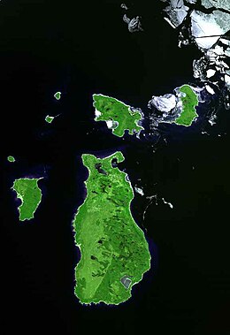
Trout Island is the small island on the far left.
USA Michigan location map.svg
Red pog.svg
Trout Island
Usa edcp location map.svg
Red pog.svg
Trout Island
Geography
Location Lake Michigan
Coordinates 45°46′19″N85°41′25″W / 45.7719416°N 85.6903683°W / 45.7719416; -85.6903683
Area80 acres (32 ha)
Highest elevation594 ft (181.1 m)
Administration
State Michigan
County Charlevoix County
Township St. James Township

Trout Island is an island in Lake Michigan and is part of the Beaver Island archipelago. [1] The island is 80 acres in size, and is privately owned. There is an airstrip on the island that extends across the whole island to both shorelines. [2] Trout Island is a little under two miles from High Island, and a little over six miles from Beaver Island. The island is part of the Beaver Island Archipelago. [3]

Related Research Articles

<span class="mw-page-title-main">Lake Michigan</span> One of the Great Lakes of North America

Lake Michigan is one of the five Great Lakes of North America. It is the second-largest of the Great Lakes by volume and depth after Lake Superior and the third-largest by surface area, after Lake Superior and Lake Huron. To the east, its basin is conjoined with that of Lake Huron through the wide and deep Straits of Mackinac, giving it the same surface elevation as its easterly counterpart; hydrologically, the two bodies are a single lake that is, by area, the largest freshwater lake in the world.

<span class="mw-page-title-main">Charlevoix County, Michigan</span> County in Michigan, United States

Charlevoix County is a county in the U.S. state of Michigan. The county seat is Charlevoix, and the largest city is Boyne City. Located in the Northern Lower Peninsula, Charlevoix County is bisected by Lake Charlevoix, Michigan's third largest inland lake. As of the 2020 census, the county's population was 26,054.

<span class="mw-page-title-main">St. James Township, Michigan</span> Civil township in Michigan, United States

St. James Township is a civil township of Charlevoix County in the U.S. state of Michigan. The population was 259 at the 2020 census.

<span class="mw-page-title-main">White River (Arkansas–Missouri)</span> River in the US

The White River is a 722-mile (1,162 km) river that flows through the U.S. states of Arkansas and Missouri. Originating in the Boston Mountains of northwest Arkansas, it arcs northwards through southern Missouri before turning back into Arkansas, flowing southeast to its mouth at the Mississippi River.

<span class="mw-page-title-main">Beaver Island (Lake Michigan)</span> Island in Charlevoix County, Michigan, USA

Beaver Island is an island in Lake Michigan in the U.S. state of Michigan. At 55.8 sq mi (145 km2), it is the largest island in Lake Michigan and the third largest island in Michigan after Isle Royale and Drummond Island. The island is located approximately 32 miles (51 km) from the city of Charlevoix. Beaver Island had a total population of 616 at the 2020 census. Beaver Island is part of Charlevoix County.

<span class="mw-page-title-main">Truckee River</span> River in Nevada and California, United States

The Truckee River is a river in the U.S. states of California and Nevada. The river flows northeasterly and is 121 miles (195 km) long. The Truckee is the sole outlet of Lake Tahoe and drains part of the high Sierra Nevada, emptying into Pyramid Lake in the Great Basin. Its waters are an important source of irrigation along its valley and adjacent valleys.

<span class="mw-page-title-main">Northern Michigan</span> Northern region of Michigans lower peninsula

Northern Michigan is a region of the U.S. state of Michigan. The region, which is distinct from the more northerly Upper Peninsula and Isle Royale, which are also located in the north of the state, is bounded to the west by Lake Michigan, and to the east by Lake Huron. The Upper Peninsula is accessible from the region via the Mackinac Bridge. While the region's southern boundary is not precisely defined, most definitions include the northernmost 21 counties of the Lower Peninsula, which had a population of 506,658 people at the 2020 census. Its largest cities are Traverse City, Cadillac, Alpena, Ludington, Manistee, and Petoskey.

The Michigan Islands National Wildlife Refuge is a designation for nine Michigan islands in the North American Great Lakes. Owned by the United States federal government, they were set aside for ecosystem protection purposes by President Franklin D. Roosevelt 1943.

<span class="mw-page-title-main">High Island (Michigan)</span>

High Island is an island in Lake Michigan and is part of the Beaver Island archipelago. It is 3,495 acres (14.14 km2) in size. The island is owned by the U.S. state of Michigan and is managed by the Michigan Department of Natural Resources as part of the Beaver Islands State Wildlife Research Area.

<span class="mw-page-title-main">Ojibwa Island</span> Island in Lake Michigan

Ojibwa Island is an island in Lake Michigan and is part of the Beaver Island archipelago. The island is about 75 acres in size, and is privately owned. Ojibwa Island is located a little under two miles north east of Whiskey Island, and a little over three miles west of Garden Island.

<span class="mw-page-title-main">St. Helena Island (Michigan)</span>

St. Helena Island is an uninhabited 240 acres (97 ha) island in the Lake Michigan approach to the Straits of Mackinac. The island is located offshore from Gros Cap, Michigan, 10 miles (16 km) west of Mackinac Island in Mackinac County in the U.S. state of Michigan.

Hog Island, an uninhabited 2,075-acre (8 km2) island in Lake Michigan, is the fourth largest island in the Beaver Island archipelago. It is owned by the U.S. state of Michigan as part of the Beaver Islands State Wildlife Research Area and is administered by the Michigan Department of Natural Resources.

The Fox Islands consist of the North Fox and South Fox Islands, in Lake Michigan. The uninhabited islands are approximately 17 miles (27 km) northwest of Cathead Point near the tip of the Leelanau Peninsula of Michigan and about 10 miles (16 km) southwest of Beaver Island. The two islands form part of an archipelago. South Fox Island Light was built in 1867 and operated until 1959. Both islands are part of Leelanau County, Michigan, and are administered by Leelanau Township. Several shipwrecks have occurred on the Fox Islands, or the reefs adjoining them; in 1851, the Illinois was reported as a "total wreck" on the Fox Island reef, In 1860, the bark Fontanelle ran aground at the Fox Islands, and in 1861, the schooner Nightingale. In 1873, the ships Frank Perew and Magnet encountered trouble at the Fox Islands.

Pismire Island is a small island in Lake Michigan of approximately 2.5 acres (1.0 ha) in size. It is part of the Beaver Island archipelago, the Michigan Islands National Wildlife Refuge, and the Michigan Islands Wilderness Area. It is managed by the U.S. Fish and Wildlife Service as a satellite of the Seney National Wildlife Refuge. It is located in St. James Township, Charlevoix County, Michigan.

Summer Island is an island in Lake Michigan, 2.5 miles (4 km) miles off the southern tip of the Garden Peninsula in the U.S. state of Michigan. It can easily be seen from Fairport, on the southern end of Delta County Road 483, the locally maintained extension of M-183, but is not accessible to the public.

<span class="mw-page-title-main">Pere Marquette River</span> River in Michigan, United States

The Pere Marquette River is a river in Michigan in the United States. The main stream of this river is 63.9 miles (102.8 km) long, running from Lake County south of Baldwin into the Pere Marquette Lake, and from there into Lake Michigan.

<span class="mw-page-title-main">East Arm Little Calumet River</span> River in Indiana, United States

The East Arm Little Calumet River, also known as the Little Calumet River East Branch, is a 22.1-mile-long (35.6 km) portion of the Little Calumet River that begins just east of Holmesville, Indiana in New Durham Township in LaPorte County and flows west to Porter County and the Port of Indiana-Burns Waterway.

<span class="mw-page-title-main">Beaver Islands State Wildlife Research Area</span> Protected areas in Michigan, United States

The Beaver Islands State Wildlife Research Area is a networked set of insular properties of the U.S. state of Michigan. The Research Area is approximately 23,154 acres in size. Properties in the Research Area include much of the southern half of Beaver Island, almost all of Garden Island, all of High Island, all of Hog Island, all of North Fox Island, and most of the northern half of South Fox Island. All of these islands are located in Lake Michigan. The insular research area is overseen by the Michigan Department of Natural Resources.

References

  1. "Report for Trout Island". USGNIS. Retrieved 12 February 2018.
  2. "The Isles of Lake Michigan - Beaver Archipeligo". Chicago Now. Retrieved 12 February 2018.
  3. "Garden and Hog Islands, Michigan". NASA Earth Observatory. Retrieved 12 February 2018.