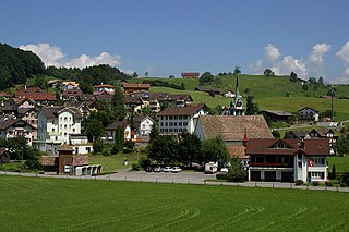
According to Walafrid Strabo the Irish missionaries Columban and Gall arrived at Tuggen around the year 610. They intended to settle in the area, but fled after Gall had burnt down a local pagan holy place. Saint Gall is today depicted on the municipality's coat of arms.
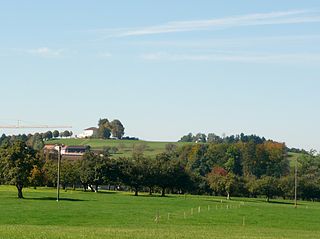
Tuggen has an area, as of 2006[update], of 13.6km2 (5.3sqmi). Of this area, 62.7% is used for agricultural purposes, while 22.1% is forested. Of the rest of the land, 11.6% is settled (buildings or roads) and the remainder (3.6%) is non-productive (rivers, glaciers or mountains).[3] The Buechberg hill is located on the area of the municipality. The former Tuggenersee was named after the municipality.
Demographics
Tuggen has a population (as of 31 December 2020) of 3,317.[4]As of 2007[update], 14.7% of the population was made up of foreign nationals.[5] Over the last 10 years the population has grown at a rate of 12.9%. Most of the population (as of 2000[update]) speaks German (90.1%), with Italian being second most common ( 2.5%) and Serbo-Croatian being third ( 1.8%).[3]
As of 2000[update] the gender distribution of the population was 50.0% male and 50.0% female. The age distribution, as of 2008[update], in Tuggen is; 735 people or 27.8% of the population is between 0 and 19. 861 people or 32.5% are 20 to 39, and 806 people or 30.5% are 40 to 64. The senior population distribution is 137 people or 5.2% are 65 to 74. There are 83 people or 3.1% who are 70 to 79 and 24 people or 0.91% of the population who are over 80.[5]
As of 2000[update] there are 1,013 households, of which 263 households (or about 26.0%) contain only a single individual. 90 or about 8.9% are large households, with at least five members.[5]
In the 2007 election the most popular party was the SVP which received 53.9% of the vote. The next three most popular parties were the FDP (21.1%), the CVP (12.4%) and the SPS (10.1%).[3]
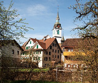
Church: Pfarrkirche Sankt Erhard
In Tuggen about 63.8% of the population (between age 25–64) have completed either non-mandatory upper secondary education or additional higher education (either university or a Fachhochschule).[3]
Tuggen has an unemployment rate of 0.91%. As of 2005[update], there were 138 people employed in the primary economic sector and about 50 businesses involved in this sector. 372 people are employed in the secondary sector and there are 42 businesses in this sector. 345 people are employed in the tertiary sector, with 71 businesses in this sector.[3]
From the 2000 census[update], 2,069 or 78.2% are Roman Catholic, while 254 or 9.6% belonged to the Swiss Reformed Church. Of the rest of the population, there are 32 individuals (or about 1.21% of the population) who belong to the Orthodox Church, and there are less than 5 individuals who belong to another Christian church. There are 124 (or about 4.69% of the population) who are Islamic. There are 8 individuals (or about 0.30% of the population) who belong to another church (not listed on the census), 86 (or about 3.25% of the population) belong to no church, are agnostic or atheist, and 72 individuals (or about 2.72% of the population) did not answer the question.[5]
The historical population is given in the following table:[5]
Steinen is a municipality in Schwyz District in the canton of Schwyz in Switzerland.
Unteriberg is a village and municipality in Schwyz District in the canton of Schwyz in Switzerland. Besides the village of Unteriberg, the municipality includes the villages of Studen, Waag, Stöcken and Herti.
Oberiberg is a village and municipality in Schwyz District in the canton of Schwyz in Switzerland. The municipality comprises the village of Oberiberg and the hamlet and ski area of Hoch-Ybrig.
Gersau is a municipality and district in the canton of Schwyz in Switzerland, sitting on the shores of Lake Lucerne. Gersau was for many centuries an independent micro-state in permanent alliance with the Swiss Confederation.
Illgau is a municipality in Schwyz District in the canton of Schwyz in Switzerland.
Ingenbohl is a municipality in Schwyz District in the canton of Schwyz in Switzerland.
Lauerz is a village and municipality in the Schwyz District of the canton of Schwyz in Switzerland. It adjoins Lake Lauerz (Lauerzersee).
Morschach is a municipality in Schwyz District in the canton of Schwyz in Switzerland. It was a world-famous resort from 1869 up to the Great Depression.
Muotathal is a village and a municipality in Schwyz District in the canton of Schwyz in Switzerland. The eponymous valley, the Muotatal, is formed by the Muota, which joins Lake Lucerne at Brunnen.
Rothenthurm is a municipality in Schwyz District in the canton of Schwyz in Switzerland.
Steinerberg is a municipality in Schwyz District in the canton of Schwyz in Switzerland.
Feusisberg is a municipality in Höfe District in the canton of Schwyz in Switzerland.
Freienbach is a municipality in Höfe District in the canton of Schwyz in Switzerland.
Wollerau is a municipality in Höfe District in the canton of Schwyz in Switzerland. It lies on the upper Zürichsee.
Altendorf is a municipality in March District in the canton of Schwyz in Switzerland.
Vorderthal is a municipality in March District in the canton of Schwyz in Switzerland.
Schübelbach is a municipality in March District in the canton of Schwyz in Switzerland.
Wangen is a municipality in March District in the canton of Schwyz in Switzerland. The municipality includes Wangen itself, together with the hamlet of Nuolen.
Wuppenau is a municipality in the district of Weinfelden in the canton of Thurgau in Switzerland.
Roggwil is a municipality in the district of Arbon in the canton of Thurgau in Switzerland.
This page is based on this Wikipedia article Text is available under the CC BY-SA 4.0 license; additional terms may apply. Images, videos and audio are available under their respective licenses.