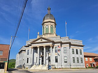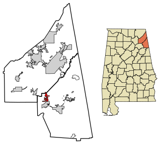
Cherokee County, Alabama is a county located in the northeastern part of the U.S. state of Alabama. As of the 2020 census, the population was 24,971. Its county seat is Centre. The county is named for the Cherokee tribe.

Etowah County is a county located in the northeastern part of the U.S. state of Alabama. As of the 2020 census the population was 103,436. Its county seat is Gadsden. Its name is from a Cherokee word meaning "edible tree". In total area, it is the smallest county in Alabama, albeit one of the most densely populated. Etowah County comprises the Gadsden Metropolitan Statistical Area.

Morgan County is a county in the north-central part of the U.S. state of Alabama. As of the 2020 census, its population was 123,421. The county seat is Decatur. On June 14, 1821, it was renamed in honor of American Revolutionary War General Daniel Morgan of Virginia. It is a prohibition or dry county, although alcohol sales are allowed in the cities of Decatur, Hartselle, and Priceville. Morgan County is included in the Decatur, AL Metropolitan Statistical Area, which is also included in the Huntsville-Decatur-Albertville, AL Combined Statistical Area. It is a part of the North, Northwest, and North-Central regions of Alabama.

Cherokee County is the westernmost county in the U.S. state of North Carolina. It borders Tennessee to its west and Georgia to its south. As of the 2020 census, the population was 28,774. The county seat is Murphy.

Centre is a city in Cherokee County, Alabama, United States. At the 2020 census, the population was 3,587. The city is the county seat of Cherokee County.

Gaylesville is a town in Cherokee County, Alabama, United States. The population was 144 at the 2010 census.

Sand Rock is a town in Cherokee and DeKalb counties in the U.S. state of Alabama. It incorporated in 1988. At the 2020 census, the population was 591.

The Qualla Boundary or The Qualla is territory held as a land trust by the United States government for the federally recognized Eastern Band of Cherokee Indians (EBCI), who reside in Western North Carolina. The area is part of the large historic Cherokee territory in the Southeast, which extended into eastern Tennessee, western South Carolina, northern Georgia and Alabama. Currently, the largest contiguous portion of the Qualla lies in Haywood, Swain, and Jackson counties and is centered on the community of Cherokee, which serves as the tribal capital of the Eastern Band of Cherokee Indians. Smaller, non-contiguous parcels also lie in Graham and Cherokee counties, near the communities of Snowbird and Murphy, respectively.
Black Fox, also called Enola, was a Cherokee leader during the Cherokee–American wars. He was a signatory of the Holston Treaty, and later became a Principal Chief of the Cherokee Nation.
New Town is an unincorporated community in Gordon County, Georgia, United States, located northeast of Calhoun. New Town is near the New Echota historic site, which was formerly part of the Cherokee Nation. Ashworth Middle School and Gordon Central High School are located in the New Town community.
The Treaty of Turkeytown, also known as the Treaty with the Cherokee and the Treaty of Chickasaw Council House (Cherokee) was negotiated on 14 September 1816, between delegates of the former Cherokee Nation on the one part and Major General Andrew Jackson, General David Meriwether and Jesse Franklin, Esq., who served as agents of the United States in the capacity of "commissioners plenipotentiary", on the other part. Conducted following the Creek War, the initial meeting was held at the Chickasaw Council House and stipulated a further meeting on 28 September 1816, to be conducted at "Turkey's Town", on the Coosa River, near the present day town of Centre, in Cherokee County, Alabama. The treaty was ratified by the Cherokee Nation at Turkeytown on 4 October 1816, and signed by Pathkiller, then Principal Chief of the Cherokee Nation.
Rock Run is an unincorporated community in Cherokee County, Alabama, United States. Rock Run is located on County Route 29, 13.6 miles (21.9 km) southeast of Centre.

Turkeytown, sometimes called "Turkey's Town", was a small Cherokee village that once stretched for approximately 25 miles along both banks of the Coosa River, and became the largest of the contemporary Cherokee towns. It was named after the original founder of the settlement, the Chickamauga Cherokee chief, Little Turkey.
Bluffton is an unincorporated community in Cherokee County, Alabama, United States.
Hurley is an unincorporated community in Cherokee County, Alabama, United States.
McGhee is an unincorporated community in Cherokee County, Alabama, United States.
Moshat is an unincorporated community in Cherokee County, Alabama, United States.
Round Mountain is an unincorporated community in Cherokee County, Alabama, United States. For a short period, it was an incorporated community beginning in 1908, and was listed in the 1910 U.S. Census as having 210 residents. That technically and briefly made it the largest town in Cherokee County, as neither the county seat of Centre nor Cedar Bluff returned census figures.
Tecumseh Furnace is an unincorporated community in Cherokee County, Alabama, United States.

The historic Cherokee settlements were Cherokee settlements established in Southeastern North America up to the removals of the early 19th century. Several settlements had existed prior to and were initially contacted by explorers and colonists of the colonial powers as they made inroads into frontier areas. Others were established later.


