
The 2003 Pacific typhoon season was a slightly below average yearlong period of tropical cyclogenesis exhibiting the development of 45 tropical depressions, of which 21 became named storms; of those, 14 became typhoons. Though every month with the exception of February and March featured tropical activity, most storms developed from May through October. During the season, tropical cyclones affected the Philippines, Japan, China, the Korean Peninsula, Indochina, and various islands in the western Pacific.

The 1989 Pacific typhoon season was the first of six consecutive years of above-average activity in the Western Pacific. It was an extremely active season spawning 32 tropical storms, 20 typhoons and five super typhoons. It has no official bounds; it ran year-round in 1989, but most tropical cyclones tend to form in the northwestern Pacific Ocean between May and November. These dates conventionally delimit the period of each year when most tropical cyclones form in the northwestern Pacific Ocean. The first storm, Winona, formed on January 15, while the final storm, Jack, dissipated on December 27. This season was also quite a deadly season that were caused by a few notable storms such as Tropical Storm Cecil, which was the worst storm to impact Vietnam in over 50 years, and Typhoon Gay, which directly impacted the Malay Peninsula as the worst typhoon in 35 years. Both of these storms make up around half of the total fatalities of the entire season alone.

The 1966 Pacific typhoon season was an active season, with many tropical cyclones having severe impacts in China, Japan, and the Philippines. Overall, there were 49 tropical depressions declared officially or unofficially, of which 30 officially became named storms; of those, 20 reached typhoon status, while 3 further became super typhoons by having winds of at least 240 km/h (150 mph). Throughout the year, storms were responsible for at least 997 fatalities and $377.6 million in damage; however, a complete record of their effects is unavailable.

Typhoon Mike, known in the Philippines as Super Typhoon Ruping, of 1990 was the strongest typhoon to hit the Philippines since Typhoon Irma in 1981 and Typhoon Nina in 1987. Forming from an area of persistent convection over the Caroline Islands, Mike was first designated on November 6, 1990 and moved generally westward. Later that day, the depression strengthened to Tropical Storm Mike near Yap. Mike became a typhoon early on November 9, and subsequently entered a period of rapid deepening. Late on November 10, the typhoon reached its maximum intensity of 115 mph (185 km/h), as estimated by the Japanese Meteorological Agency. After weakening slightly, Mike made landfall in the central Philippines. The storm weakened considerably due to land interaction, only to briefly re-intensify on November 14. Typhoon Mike turned west-northwest and later north-northwest, avoiding land interaction with Vietnam. Vertical wind shear increased, and on November 15, Mike weakened below typhoon intensity. Early the next day, the storm passed over western Hainan Island, and degraded to a tropical depression that night. After briefly emerging into the Gulf of Tonkin, Mike passed over Northern Vietnam and southern China, where it dissipated on November 18.

The 1964 Pacific typhoon season was the most active tropical cyclone season recorded globally, with a total of 39 tropical storms forming. It had no official bounds; it ran year-round in 1964, but most tropical cyclones tend to form in the northwestern Pacific Ocean between June and December. These dates conventionally delimit the period of each year when most tropical cyclones form in the northwestern Pacific Ocean.

Typhoon Ike, known in the Philippines as Typhoon Nitang, was the second deadliest tropical cyclone in the 20th century in the Philippines. Ike originated from an area of disturbed weather southeast of Guam on August 21, 1984, and five days later, developed into a tropical depression. Following an increase in organization, the depression attained tropical storm intensity on August 27. Initially tracking west-southwest, the storm gradually gained strength as wind shear resulted relaxed and Ike became a typhoon on August 30. Continuing to rapidly intensity, Ike turned west and attained peak intensity on September 1, with the Japan Meteorological Agency estimating winds of 170 km/h (105 mph). At around 14:00 UTC that day, Ike made landfall on the northeastern tip of Mindanao. The cyclone emerged into the South China Sea on September 3 as a tropical storm before re-intensifying into a typhoon and moving onshore Hainan. Ike then struck the Chinese mainland as a tropical storm in Guangxi and dissipated on September 6.
Typhoon Nina, known in the Philippines as Typhoon Sisang, was the most intense typhoon to strike the Philippines since Typhoon Irma in 1981. Typhoon Nina originated from an area of convection near the Marshall Islands in mid-November 1987. It gradually became better organized, and on November 19, was first classified as a tropical cyclone. Moving west-northwest, Nina attained tropical storm intensity that evening. Late on November 20, Nina passed through the Chuuk Lagoon in the Federated States of Micronesia. After a brief pause in intensification, Nina intensified into a typhoon on November 22. Two days later, the typhoon intensified suddenly, before attaining its peak 10 minute intensity of 165 km/h. During the afternoon of November 25, Nina moved ashore in Southern Luzon at the same intensity. It gradually weakened over land, before entering the South China Sea and turning to the north. By November 30, Nina dissipated.

Typhoon Babs, known in the Philippines as Typhoon Loleng, was a powerful typhoon that struck the Philippines days after Typhoon Zeb hit the same area. The seventh typhoon of the inactive 1998 Pacific typhoon season, Babs formed on October 14 between the Philippines and Guam. The storm moved westward initially, failing to intensify initially due to the outflow from Typhoon Zeb to the northwest. Babs slowed and briefly turned to the south before advancing to the northwest, whereupon it rapidly intensified into a strong typhoon. On October 20, the official Japan Meteorological Agency (JMA) estimated peak 10‑minute winds of 155 km/h (96 mph), while the unofficial Joint Typhoon Warning Center (JTWC) estimated peak 1‑minute winds of 250 km/h (160 mph), making Babs an unofficial super typhoon. The storm struck the Philippine island of Catanduanes at that intensity and weakened slightly before hitting Luzon. Babs turned northward once in the South China Sea, later weakening due to unfavorable conditions and transitioning into an extratropical cyclone on October 27 in the Taiwan Strait.
Typhoon Dot, known in the Philippines as Typhoon Saling, was the strongest storm of the 1985 season. Dot originated from a small area of thunderstorm activity in early to mid October. The system was first classified on October 11, and steadily intensified over the next few days. Dot attained typhoon strength on October 15, and subsequently entered a period of explosive deepening, which was not anticipated by forecasters. The next day the intensification rate slowed, but that evening, Dot attained its maximum intensify. A steady weakening trend began on October 17, though the system maintained typhoon intensity through the passage of the Philippines. After entering the South China Sea late on October 18, Dot briefly re-intensified, only to weaken as it approached Vietnam. On October 21, Dot struck Vietnam while still a typhoon, but dissipated the next day over the high terrain of the nation.

Typhoon Chanchu, known in the Philippines as Typhoon Caloy, was the most intense typhoon in the South China Sea in the month of May according to the Hong Kong Observatory (HKO). The first named storm of the 2006 Pacific typhoon season, Chanchu formed on May 8 in the vicinity of the Federated States of Micronesia and progressed westward. It gradually intensified into a tropical storm and later severe tropical storm before moving through the Philippines. On May 13, Chanchu entered the South China Sea and became a typhoon, according to the Japan Meteorological Agency (JMA). Warm waters and favorable outflow allowed the storm to quickly intensify to peak maximum sustained winds of 175 km/h (109 mph) on May 15. Around that time, the typhoon turned sharply to the north toward southeastern China. Chanchu weakened as it curved to the northeast, making landfall near Shantou, Guangdong on May 17 as a severe tropical storm. The government of China considered Chanchu the earliest typhoon to make landfall in the province. On the next day, the storm emerged into the East China Sea, becoming extratropical on May 19 before dissipating west of Kyushu.

Typhoon Utor, known in the Philippines as Typhoon Seniang, swept through the central Philippines in December 2006, exacerbating the damage left behind by previous Philippine typhoon strikes that year. Residual moisture from the tropical cyclone indirectly contributed to extensive flooding in Malaysia. Utor originated from an area of disturbed weather that organized into a tropical depression on December 7 west-southwest of Yap. The cyclone steadily progressed westward while gradually intensifying, reaching tropical storm intensity late on December 7. On December 9 and the ensuing two days, Utor crossed the central Philippines and reached typhoon strength before weakening somewhat upon entry into the South China Sea. Reintensification ensued afterwards, and Utor reached its peak intensity on December 13 with maximum sustained winds of 155 km/h (100 mph) shortly after regaining typhoon strength. However, wind shear and dry air began to take its toll on Utor thereafter, quickly weakening the storm until its dissipation on December 15.

Typhoon Ruby, known in the Philippines as Typhoon Unsang, was the strongest typhoon to strike the Philippines in 18 years. The tenth typhoon of the 1988 Pacific typhoon season, Ruby formed from an area of low pressure situated east of the Philippines on October 20. The storm steadily intensified as it moved west, and then west-northwest. After developing an eye, Ruby attained typhoon intensity on October 23 and began to strengthen at a brisker clip. Ruby reached maximum intensity later that day, before moving ashore along the central portion of Luzon early on October 24. The storm steadily weakened over land and this trend only continued after Ruby entered the South China Sea. On October 27, Ruby made a second landfall as a tropical storm on Hainan Island before dissipating the next day.

Typhoon Irma, known in the Philippines as Typhoon Daling, affected the Philippines in late June 1985. Typhoon Irma originated from a monsoon trough situated near Guam in the Western Pacific Ocean. It slowly developed, with insufficient organization delaying classification as a tropical cyclone. By June 24, organization improved as the system encountered favorable conditions aloft and the disturbance attained tropical storm intensity the next day. Moving west, Irma gradually deepened, and on June 28, it was believed to have attained typhoon intensity. On the morning of June 27, Irma was upgraded into a typhoon. After passing northeast of the Philippines, Typhoon Irma attained its peak intensity on June 29. Accelerating to the north and then the northeast, Irma steadily weakened as it encountered significantly less favorable conditions. The typhoon made landfall in central Japan on June 30. Irma weakened below typhoon intensity the next day, and later on July 1, Irma transition into an extratropical cyclone. The remnants of the cyclone were tracked until July 7, when it merged with an extratropical low south of the Kamchatka Peninsula.

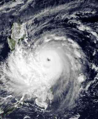
Typhoon Cimaron, known in the Philippines as Super Typhoon Paeng, was the most intense tropical cyclone to strike the Philippine island of Luzon since Typhoon Zeb in 1998. Originating from a tropical depression on October 25, Cimaron developed within an environment strongly favoring tropical cyclogenesis east of the Philippines. On October 28, the system underwent rapid intensification, culminating in attaining its peak strength with winds of 185 km/h (115 mph). Estimates from the Joint Typhoon Warning Center ranked the system as a Category 5-equivalent super typhoon with one-minute sustained winds of 260 km/h (160 mph), though this is argued to have underrepresented the typhoon's strength. The system moved ashore near Casiguran, Aurora in northern Luzon at peak strength. Crossing the island, Cimaron emerged over the South China Sea where conditions allowed for temporary reorganization. After becoming nearly stationary on November 1, the typhoon executed a tight anti-cyclonic loop and rapidly weakened. The storm degenerated into a tropical depression on November 4, before dissipating three days later off the coast of Vietnam.

Typhoon Rita, known in the Philippines as Typhoon Gloring, was one of the longest-lived Western Pacific tropical cyclones on record. Rita traversed the basin along an erratic path for 22 days. The second of four simultaneously developing storms, Rita was first identified to the southeast of Guam on July 5, 1972.

Severe Tropical Storm Tess known in the Philippines as Tropical Storm Welpring was the second of three tropical cyclones to directly impact the Philippines in a two-week time frame in 1988. An area of disturbed weather near the Philippines was first observed on November 1. Following an increase in organization, the disturbance was designated as a tropical cyclone on November 4. Moving west, Tess steadily strengthened due to favorable conditions aloft. During the evening of November 5, Tess was estimated to have achieved its highest intensity, with winds of 115 km/h (70 mph). Rapid weakening then ensured as Tess neared Vietnam, and after making landfall in the country on November 6, Tess dissipated the next day.

Typhoon Ofelia, known as Typhoon Bising in the Philippines, was the first of two typhoons in 1990 to directly affect the Philippines within a week. Typhoon Ofelia originated from an area of disturbed weather embedded in the monsoon trough situated near the Caroline Islands. Slowly organizing, the disturbance tracked westward, and was designated a tropical depression on June 15. After an increase in convection, the depression was upgraded into a tropical storm on June 17. On June 19, Ofelia turned northwest and after development of a central dense overcast, Ofelia was upgraded into a typhoon late on June 20. After turning north, Ofelia obtained its maximum intensity following the development of an eye. The typhoon skirted past the northeastern tip of Luzon and near the east coast of Taiwan, commencing a rapid weakening trend. On the evening on June 23, Ofelia struck the southern portion of Zhejiang. The storm then began to track north, recurving towards the Korean Peninsula. The storm tracked through the province of Jiangsu, and at 00:00 UTC on June 24, transitioned into an extratropical cyclone, only to merge with a frontal zone on June 25.

Typhoon Eli, known in the Philippines as Typhoon Konsing, struck the Philippines and Hainan during mid-July 1992. A weak low pressure system developed in the Philippine Sea on July 7, which became a tropical depression on the next day. The depression tracked west-northwest and strengthened into a tropical storm on July 10. After turning more westward, Eli steadily intensified, and obtained typhoon intensity that evening. The storm attained its highest intensity of 130 km/h (80 mph) early on July 11 before striking northern Luzon. After entering the South China Sea, the storm maintained most of its intensity as it approached Hainan, although agencies disagree on how precisely strong it was. After passing through Hainan late on July 13, Eli passed through the Gulf of Tonkin on the next day before striking Vietnam, where Eli quickly dissipated.

Typhoon Flo, known in the Philippines as Typhoon Kadiang, was a catastrophic and deadly minimal typhoon that hit the northern Philippines during October 1993. It also caused the largest 72-hour forecast error for the year due to its interaction with the nearby Super Typhoon Ed. The twenty-seventh depression, twenty-second named storm and the eleventh typhoon of the 1993 Pacific typhoon season, Flo originated from an area of convection that was embedded from a monsoon trough during September 28. Two days later, a tropical depression formed within this trough, to the west of Guam. Slowly organizing, it remained a tropical depression until on October 2, when it strengthened to a tropical storm and was given the name Flo by the Japan Meteorological Agency. Slight wind shear from nearby Ed inhibited development; however, it intensified to a minimal typhoon as it neared the coastline of Luzon. On October 3, it made landfall near the Isabela-Aurora in its peak. It then crossed the country while weakening, and moved ashore near the South China Sea the next morning. It then unexpectedly moved back to the country due to its interaction with Ed, and it moved back to the Philippine Sea on October 17 before accelerating to the south of Japan. It then became extratropical on the next day.

Typhoon Opal, known in the Philippines as Super Typhoon Naning, was an intense Category 5-equivalent typhoon in the extremely active 1964 Pacific typhoon season. Opal also had the largest wind circulation of any typhoon in 1964, with a total span of 2,100 km (1,300 mi).Data from the Joint Typhoon Warning Center (JTWC) indicated that Opal's winds were the highest of any typhoon in 1964. As the thirty-ninth named storm and the twenty-sixth typhoon of the season, it originated from a tropical wave in early December, with its wind circulation developing by December 8. This system quickly organized, gaining the name Opal, and reaching typhoon status on December 9. Opal moved through Yap and Palau for two days. On that last day, Opal reached its peak intensity with one-minute sustained winds of 315 km/h (196 mph) and a central pressure of 895 hPa (26.43 inHg). On December 14, Opal passed north of some Filipino islands and its winds began to lose intensity. Later that day, Opal made landfall in the Philippines with one-minute sustained winds of 140 km/h (87 mph). Opal weakened further as it moved over Luzon. Its center then executed a small counterclockwise loop over western Luzon before curving north and briefly emerging into Lingayen Gulf as a tropical storm. Opal crossed northwestern Luzon and the Babuyan Islands on December 16 and later became extratropical near Okinawa on December 17; this phase of Opal's development dissipated the next day.


