
Hanham is in the unitary authority of South Gloucestershire, adjacent to, but not within the City of Bristol. It became a civil parish on 1 April 2003.

Chipping Sodbury is a market town and civil parish in the unitary authority area of South Gloucestershire, in the county of Gloucestershire, England. It is situated 13 miles (21 km) north-east of Bristol and directly east of Yate. The town was founded in the 12th century by William le Gros. It is the main settlement in the civil parish of Sodbury, which also includes the village of Old Sodbury.

Wickwar is a village and civil parish in Gloucestershire, England, located between Yate and Charfield. At the 2001 census, the parish had a population of 1,943.
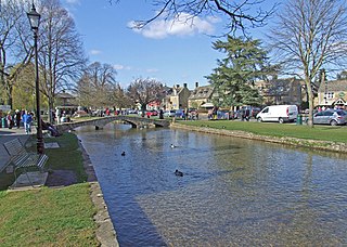
Bourton-on-the-Water is a village and civil parish in Gloucestershire, England, that lies on a wide flat vale within the Cotswolds Area of Outstanding Natural Beauty. The village had a population of 3,296 at the 2011 census. Much of the village centre is a designated Conservation Area.
Tytherington is a village in the civil parish of Tytherington and Itchington, in the South Gloucestershire district, in the ceremonial county of Gloucestershire, England, situated 2 miles (3.2 km) south east of Thornbury. The parish population taken at the 2011 census was 666. On 1 April 2023 the parish was renamed from "Tytherington" to "Tytherington and Itchington".

Hallen is a village in South Gloucestershire, England, just north of the Bristol city boundary. It is southwest of Easter Compton, northeast of Avonmouth and northwest of Henbury. The village lies at the edge of the Severn floodplain, sandwiched between the M49 and M5 motorways. It is sometimes claimed that the name "Hallen" is from the Welsh for salt, 'halen', or from an Anglo-Saxon word of the same meaning, however, 16th century spellings make it clear that this is not the case; the name is apparently Middle or Early Modern English from 'hall' (hall) or 'hale' + 'ende' (end).

Hardwicke is a large village on the A38 road 7 km south of the city of Gloucester, Gloucestershire, England. Despite its proximity to Gloucester, the village comes under Stroud Council. The population of the village taken at the United Kingdom Census 2011 was 3,901.

Elmstone Hardwicke is a village and sizeable parish north-west of Cheltenham in Gloucestershire, England.

Stoke Orchard is a village or hamlet approximately 2.5 miles (4.0 km) north-west of Cheltenham in Gloucestershire, England.
Tredington is a village and former civil parish, now in the parish of Stoke Orchard near Tewkesbury, in the Tewkesbury district, in the county of Gloucestershire, England. The village has a church and a school. In 1931 the parish had a population of 92.
Knightsbridge is a hamlet neighbouring Elmstone-Hardwicke and Uckington, close to Junction 10 of the M5 motorway, near Cheltenham in Gloucestershire, England. In addition to residential housing, Knightsbridge is home to a small business park.

Rangeworthy is a semi-rural farming village in South Gloucestershire, England, nearby communities include Falfield and Charfield. The village population taken at the 2011 census was 675.

Quedgeley is a town and civil parish in the city of Gloucester district in Gloucestershire, England. A thin strip of land between the Severn and the Gloucester Ship Canal occupies the west, and the south-eastern part of the town is Kingsway Village, directly to the north of which is Tuffley.

Andoversford is a village and civil parish in the Cotswold District of Gloucestershire, England, about 5 miles (8 km) east of Cheltenham. The village is on the River Coln, parallel to the A40.The 2011 Census recorded the parish's population as 555. In 2019 the parish a population of 905.

Preston or Preston-next-Wingham is a civil parish and village in the valley of the Little Stour in the Dover District of Kent, England. The village is on the B2076 secondary road. The parish includes the hamlet of Elmstone. The main river through the area is a tributary of the River Stour. The suffix 'next-Wingham' distinguishes the area from Preston-next-Faversham.
Rodborough is a large village and civil parish in the district of Stroud, Gloucestershire, in South West England. It is directly south of the town of Stroud, north of the town of Nailsworth and north-west of the town of Minchinhampton. The parish includes the settlements of Bagpath, Butterrow, Kingscourt, Lightpill and Rooksmoor, and is adjacent to the Stroud suburb of Dudbridge. The population taken at the 2011 census was 5,334.

Elmstone is a village and former civil parish, now in the parish of Preston, in the Dover district, in East Kent, England. It is situated between Canterbury and Sandwich. The Domesday Book of 1086 records Elmstone as 'Aelvetone'. In 1086 the recorded population was 3 households. In 1931 the parish had a population of 117. On 1 April 1935 the parish was abolished and merged with Preston, part also went to Wingham.

Haresfield is a village near Gloucester, Gloucestershire, England around one mile from Junction 12 of the M5 motorway and between the villages of Brookthorpe, Harescombe and Hardwicke. The population of the village taken at the 2011 census was 378.

Longford is a village and civil parish in Gloucestershire, England. Although situated within two miles of Gloucester city centre, Longford parish falls within the jurisdiction of the Borough of Tewkesbury.

