Mbala is Zambia's most northerly large town and seat of Mbala District in Northern Province, occupying a strategic location close to the border with Tanzania and controlling the southern approaches to Lake Tanganyika, 40 km by road to the north-west, where the port of Mpulungu is located. It had a population of about 20,000 in 2006. Under the name Abercorn, Mbala was a key outpost in British colonial control of this part of south-central Africa.

Rukwa Region(Mkoa wa Rukwa in Swahili) is one of Tanzania's 31 administrative regions The region covers a land area of 27,765 km2 (10,720 sq mi), which is comparable in size to the combined land area of the nation state of Haiti. Rukwa Region is bordered to the north by Katavi Region, to the east by Songwe Region, to the south by the nation of Zambia and to the west by Lake Tanganyika, which forms a border between Tanzania and the Democratic Republic of the Congo. The regional capital is the municipality of Sumbawanga. According to the 2022 national census, the region had a population of 1,540,519.
The Kipengere Range, also known as the Livingstone Mountains, lies entirely in Njombe Region in southwest Tanzania at the northern end of Lake Nyasa. Near Lake Nyasa they are known as the Kinga Mountains. It is a plateau-like ridge of mountains running southeastwards from the basin of the Great Ruaha River in the north to that of the Ruhuhu River in the south, and forms part of the eastern escarpment of the East African Rift. The range is mostly clad in montane grasslands, renowned for their botanical diversity and displays of flowers, with montane evergreen forests mostly in stream valleys.
The Udzungwa Mountains are a mountain range in south-central Tanzania. The mountains are mostly within Iringa Region, south of Tanzania's capital Dodoma. The Udzungwa Mountains are part of the Eastern Arc Mountains, and are home to a biodiverse community of flora and fauna with large numbers of endemic species.

The Cross–Sanaga–Bioko coastal forests are a tropical moist broadleaf forest ecoregion of west-central Africa. This is a lush forest, rich in flora and birdlife.

The Albertine Rift is the western branch of the East African Rift, covering parts of Uganda, the Democratic Republic of the Congo (DRC), Rwanda, Burundi and Tanzania. It extends from the northern end of Lake Albert to the southern end of Lake Tanganyika. The geographical term includes the valley and the surrounding mountains.
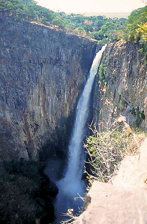
The Kalambo River forms part of the border between Zambia and Tanzania. It is a comparatively small stream which rises on the Ufipa Plateau in Rukwa Region,Tanzania]] north-east of Mbala at an elevation of about 1,800 metres (5,900 ft) and descends into the Albertine Rift, entering the southeastern end of Lake Tanganyika at an elevation of about 770 metres (2,530 ft), in a straight-line distance of only about 50 kilometres (31 mi). This accounts for its main claim to fame, its waterfall, Kalambo Falls, which is Africa's second highest falls. Below the falls, the river runs in a deep gorge.

The Ugandan red colobus or ashy red colobus is an endangered species of red colobus monkey, recognised as a distinct species since 2001. There is disagreement however over taxonomy with many considering the Ugandan red colobus to be a subspecies. The Ugandan red colobus is an Old World monkey which is found in five different locations across Uganda and Tanzania.
The Southern Highlands is a highland region in southwestern Tanzania, at the northern end of Lake Malawi. The highlands include portions of Mbeya, Njombe, Rukwa, Ruvuma, and Songwe regions, bordering Malawi, Mozambique, and Zambia. Mbeya is the largest city in the highlands.

The Rukwa Valley is a valley located in Rukwa Region, Songwe Region and Katavi Region in southwestern Tanzania. The valley is a part of the Great Rift Valley. Sparsely populated because of its harsh environment, its grassland biodiversity includes thousands of species.

The Mbulu Highlands is a plateau in north-central Tanzania.

Katavi Region is one of Tanzania's 31 administrative regions. The region covers an area of 45,843 km2 (17,700 sq mi). The region is comparable in size to the combined land area of the nation state of Estonia. Katavi Region is bordered to the east by Tabora Region, and to the south by Rukwa Region and Songwe Region. Lastly, Katavi borders DRC on Lake Tanganyika to the west. The region derives its name from Katavi, the spirit of lake Tanganyika. The regional capital city is Mpanda. According to the 2022 national census, the region had a population of 1,152,958.

Kalambo District is one of the four districts of the Rukwa Region of Tanzania, East Africa. The administrative seat is in Matai. The Kalambo River flows through the district and its mouth on Lake Tanganyika is about 15 km south of the town of Kasanga.

Songwe Region is one of Tanzania's 31 administrative regions. The region covers a land area of 27,656 km2 (10,678 sq mi). The region is comparable in size to the combined land area of the nation state of Haiti. Songwe Region borders the countries of Zambia and Malawi to the south: Tunduma is the main entry point into Zambia while Isongole is the main entry point into Malawi. Songwe also borders the Tanzanian regions of Rukwa and Katavi in the west, Tabora in the north, and Mbeya in the east. Lake Rukwa is a major body of water in the western part of the region. The region was created on 29 January 2016 from the western half of Mbeya Region. The regional capital is Vwawa. According to the 2022 national census, the region had a population of 1,344,687.
The M1 road is a road in northern Zambia. It connects Mpika in Muchinga Province with Mbala in the Northern Province on the border with Tanzania and the Lake Tanganyika port of Mpulungu via Kasama. The northern section is a toll road.

The South Malawi montane forest-grassland mosaic is a montane grasslands and shrublands ecoregion of Tanzania, Malawi, Mozambique, and Zambia.
Ntchisi Mountain is a mountain in central Malawi. It is located in Ntchisi District, east of the town of Ntchisi.
The Misuku Hills are a mountain range in Malawi's Northern Region.
The Rubeho Mountains are a mountain range in central Tanzania. The mountains in Dodoma and Morogoro regions, southeast of Tanzania's capital Dodoma. The Rubeho Mountains are part of the Eastern Arc Mountains, and are home to a biodiverse community of flora and fauna with large numbers of endemic species.