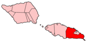
Apia is the capital of Samoa, and its only city. It is located on the central north coast of Upolu, Samoa's second-largest island. Apia falls within the political district (itūmālō) of Tuamasaga.

Upolu is an island in Samoa, formed by a massive basaltic shield volcano which rises from the seafloor of the western Pacific Ocean. The island is 75 kilometres long and 1,125 square kilometres in area, making it the second largest of the Samoan Islands by area. With approximately 145,000 inhabitants, it is by far the most populous of the Samoan Islands. Upolu is situated to the southeast of Savai'i, the "big island". Apia, the capital, is in the middle of the north coast, and Faleolo International Airport is at the western end of the island. The island has not had any historically recorded eruptions, although there is evidence of three lava flows, dating back only to between a few hundred and a few thousand years ago.

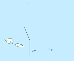
The Samoan Islands are an archipelago covering 3,030 km2 (1,170 sq mi) in the central South Pacific, forming part of Polynesia and of the wider region of Oceania. Administratively, the archipelago comprises all of the Independent State of Samoa and most of American Samoa. The land masses of the two Samoan jurisdictions are separated by 64 km (40 mi) of ocean at their closest points.
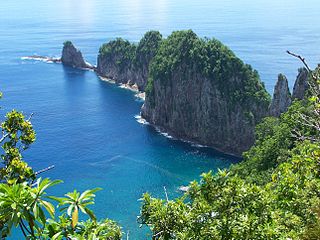
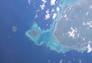
The National Park of American Samoa is a national park in the United States territory of American Samoa, distributed across three islands: Tutuila, Ofu, and Ta‘ū. The park preserves and protects coral reefs, tropical rainforests, fruit bats, and the Samoan culture. Popular activities include hiking and snorkeling. Of the park's 8,257 acres (3,341 ha), 2,500 acres (1,000 ha) is coral reefs and ocean. The park is the only American National Park Service system unit south of the equator.
Manono is an island of Samoa, situated in the Apolima Strait between the main islands of Savai'i and Upolu, 3.4 km west-northwest off Lefatu Cape, the westernmost point of Upolu.

Poloa is a village in American Samoa. It is located at the west side of Tutuila in the Alataua District. The village has 193 residents in 2010. The main denominations in the area are Methodist and Christian. Poloa has one elementary school. It is located in Lealataua County.

Lalomanu is a village on the east coast of Upolu island in Samoa.The village is part of the electoral constituency Aleipata Itupa i Luga which is within the larger political district of Atua. It has a population of 712.

Vavau is a small village on south east end of Upolu island in Samoa. The village is part of the Lotofaga Electoral Constituency which is within the larger political district of Atua.
Lepa is a small village at the southeastern end of Upolu island in Samoa. The village has a population of 166.

Leone is the second-largest city on Tutuila Island's west coast. The village is on the south-west coast of Tutuila Island, American Samoa. Leone was the ancient capital of Tutuila Island. Leone was also where the Samoan Islands’ first missionary, John Williams, visited on October 18, 1832. A monument in honor of Williams has been erected in front of Zion Church. Its large church was the first to be built in American Samoa. It has three towers, a carved ceiling and stained glass. Until steamships were invented, Leone was the preferred anchorage of sailing ships which did not risk entering Pago Pago Harbor. Much early contact between Samoans and Europeans took place in Leone.

American Samoa is an unincorporated territory of the United States located in the South Pacific Ocean, southeast of the independent nation of Samoa. Its location is centered on 14.3°S 170.7°W. It is east of the International Date Line, while Samoa is west of the Line. The total land area is 199 square kilometers (76.8 sq mi), slightly more than Washington, D.C. American Samoa is the southernmost territory of the United States and one of two U.S. territories south of the Equator, along with the uninhabited Jarvis Island. Tuna products are the main exports, and the main trading partner is the rest of the United States.
'Amanave is a village on the coast of Tutuila Island, American Samoa. It is located close to the island's western tip, Cape Taputapu, and to the south of the village of Poloa. It is located in Lealataua County.

Pago Pago Harbor on Tutuila Island in American Samoa is one of the world's largest natural harbors. The capital, Pago Pago is located on the inner reaches of the harbor, close to its northwesternmost point. It has the highest annual rainfall of any harbor in the world. It is also considered one of the best and deepest deepwater harbors in the South Pacific Ocean or in Oceania as a whole. Pago Pago Bay is over 400 feet (120 m) deep and two miles (3.2 km) long. As part of the Pago Volcano caldera, the harbor is 50% landlocked,
Faga'itua is a village in the east of Tutuila Island, American Samoa. It is located on the central coast of Faga'itua Bay. It is in Sua County, a county also known as ‘o le falelima i sasa’e. Fagaitua is located at a shallow bay on the south coast of the island, in-between Lauli'i and Alofau. It is home to Luafagā, Le’iato's house of chiefs, and the big malae Malotumau.
The 2009 Samoa earthquake and tsunami took place on 29 September 2009 in the southern Pacific Ocean adjacent to the Kermadec-Tonga subduction zone. The submarine earthquake occurred in an extensional environment and had a moment magnitude of 8.1 and a maximum Mercalli intensity of VI (Strong). It was the largest earthquake of 2009.
Poutasi is a village on the south east coast of Upolu island in Samoa. The population is 395. The village is part of Falealili Electoral Constituency in the larger political district of Atua. Poutasi was extensively damaged by the 2009 Samoa earthquake and tsunami.

Hihifo is the main village on the island of Niuatoputapu in the Kingdom of Tonga. Hihifo is situated on the west side of Niuatoputapu and is the main centre for public and government facilities that serve the island residents, including a post office and police station. The other two villages on Niuatoputapu are Falehau and Vaipoa.
The 1917 Samoa earthquake occurred on June 26 at 05:49 UTC. The epicenter was located in the southwest of the Samoan Islands. The earthquake had a magnitude of 8.5, or 8.4, one of the strongest earthquakes ever recorded in this region.
Satala is one of Pago Pago’s constituent villages and is located in Pago Pago Bay on Tutuila Island. Satala is in Maoputasi County in the Eastern District of the island. It is home to the historic Satala Cemetery, which is listed on the U.S. National Register of Historic Places, and the government-owned Ronald Reagan Marina Railway Shipyard.