Related Research Articles
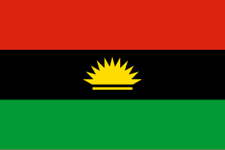
Biafra, officially the Republic of Biafra, was a partially recognised secessionist state in West Africa that declared independence from Nigeria and existed from 1967 until 1970. Its territory consisted of the predominantly Igbo-populated former Eastern Region of Nigeria. Biafra was established on 30 May 1967 by Igbo military officer and Eastern Region governor C. Odumegwu Ojukwu under his presidency, following a series of ethnic tensions and military coups after Nigerian independence in 1960 that culminated in the 1966 massacres of Igbo people and other Eastern ethnic groups living in northern Nigeria. The military of Nigeria proceeded to invade Biafra shortly after its secession, resulting in the start of the Nigerian Civil War.

Port Harcourt is the capital and largest city in Rivers State, Nigeria. It is the fifth most populous city in Nigeria after Lagos, Kano, Ibadan and Benin. It lies along the Bonny River and is located in the Niger Delta. As of 2016, the Port Harcourt urban area had an estimated population of 1,865,000 inhabitants, up from 1,382,592 as of 2006. The population of the metropolitan area of Port Harcourt is almost twice its urban area population with a 2015 United Nations estimate of 2,344,000. In 1950, the population of Port Harcourt was 59,752. Port Harcourt has grown by 150,844 since 2015, which represents a 4.99% annual change. Historically it has been known as Obomuotu Country within which a few other smaller areas were called Diobu or Igweocha (city).
Anambra State is a Nigerian state, located in the southeastern region of the country. The state was created on 27 August 1991. Anambra state is bounded by Delta State to the west, Imo State to the south, Enugu State to the east and Kogi State to the north.
The Niger Delta is the delta of the Niger River sitting directly on the Gulf of Guinea on the Atlantic Ocean in Nigeria. It is located within nine coastal southern Nigerian states, which include: all six states from the South South geopolitical zone, one state (Ondo) from South West geopolitical zone and two states from South East geopolitical zone.

Ebonyi State is a state in the South-East geopolitical zone of Nigeria, bordered to the north and northeast by Benue State, Enugu State to the west, Cross River State to the east and southeast, and Abia State to the southwest. Named for the Abonyi (Aboine) River—a large part of which is in the state's south—Ebonyi State was formed from parts of Abia and Enugu state in 1996 and has its capital as Abakaliki.

Enugu State is a state in the South-East geopolitical zone of Nigeria, bordered to the north by the states of Benue and Kogi, Ebonyi State to the east and southeast, Abia State to the south, and Anambra State to the west. The state takes its name from its capital and largest city, Enugu.
Igboland, also known as Southeastern Nigeria, is the indigenous homeland of the Igbo people. It is a cultural and common linguistic region in southern Nigeria. Geographically, it is divided by the lower Niger River into two sections: an eastern and a western one. Its population is characterised by the diverse Igbo culture and the speakers of equally diverse Igbo languages.
Ikwerre, sometimes spelt as Ikwere, is a type of Igboid language spoken primarily by the Ikwerre people, who inhabit certain areas of Rivers State, Nigeria. It is the biggest Igboid variety along with Ngwa of Abia State.
Umunoha is a town in southeastern Nigeria near the city of Owerri. It is a typical Igbo town. It is bounded on the north by Eziama Obiato and Afara communities; on the south and southwest by Ogbaku, Azara Obiato and Ejemekwuru communities; and on the south and southeast by Ifakala and Afara communities. It is served by the great east-west road, the Port-Harcourt-Lagos Highway. Umunoha is about thirteen kilometers from Owerri, the Imo State capital. It is a small, compact but thickly populated community with a projected 1997 population of twenty-five thousand people.

The Ikwerre is one of the Igbo subgroups in Rivers State. They are the biggest ethnic group in Rivers state.Traditional history has classified Ikwerre into seven groups called "Ikwerre Essa". They are Elele, Isiokpo, Rumuji, Emohua, Choba, Aluu Igwuruta and Obio group. This division was recognized by Forde and Jones; (1950) in their ethnographic study of the Igbo speaking peoples of South Eastern Nigeria though has been disputed by indigenous ikwerre people. It was also in line with this grouping those seven customary Courts were established in Ikwerre during the Colonial administration. These Courts were located at Elele, Isiokpo, Umuji, Emohua, Choba, Aluu and Obio in Ikwerreland.
Chokocho is a community in Etche Local Government Area in Rivers State, Nigeria near the Otamiri River. It has a population of about 18000 residents. The Chokocho bridge across the Otamiri, damaged during the Nigerian civil war, was rebuilt during the governorship of Peter Odili. The bridge on the Igwuruta – Okehi – Okpalla road is 60m x 11m, built by Setraco Nigeria Ltd and completed in December 2002. In March 2008, Ephraim Nwuzi of the Etche Local Government Area said he was going to complete "abandoned projects" like the cottage hospital at Chokocho.

Etche is one of the 23 Local Government Areas of Rivers State and amongst the 13 federal constituencies representing River State in Nigeria's National Assembly and part of the Rivers East Senatorial District.

Ukwa West is a Local Government Area in Abia State, Nigeria. Its headquarters is in the town of Oke Ikpe.
Amadioha is the Arusi or Agbara of thunder and lightning of the Igbo people of southeastern Nigeria. He is amongst the most popular of Igbo deities and in some parts of Igboland, he is referred to as Amadiora, Kamalu, Kamanu, or Ofufe. Astrologically, his governing planet is the Sun. His color is red, and his symbol is a white ram. Metaphysically, Amadioha represents the collective will of the people. He is often associated with Anyanwu, who is the Igbo god of the Sun. While Anyanwu is more prominent in northern Igboland, Amadioha is more prominent in the southern part. His day is Eke, which is the first market day of the Igbo four-day week.
Oʼchiʼchiʼ (Ọchịchị) is a recently discovered and presumably extinct Central Delta language of Nigeria. Its first published reference was in 2002. It was spoken by a few elders in the villages of Ikwewengwo and Umuebulu in the Etche Local Government Area of Rivers State.

Awo-Omamma, in the Northeast of Niger Delta basin is an oil-rich indigenous Igbo town on the banks of Njaba River. It is a potential tourism hub in the region due to its species of wildlife in Umuezukwe and green vegetation.
The South South is the one of the six geopolitical zones of Nigeria representing both a geographic and political region of the country's eastern coast. It comprises six states – Akwa Ibom, Bayelsa, Cross River, Delta, Edo, and Rivers.
References
- ↑ "Shells'S Toxic War Against Umuakuru-Igbo People". essentialaction.org. Retrieved 30 December 2014.
- ↑ "Capacity Building and Youth Skills Acquisition in Beekeeping at Imeh & Umuakuru communities in Etche 1 Cluster, Etche LGA, Rivers state, Nigeria". sgp.undp.org. Retrieved 30 December 2014.
Capital: Port Harcourt | |
| Topics | |
| Communities | |
| Cities and towns | |
| LGA(s) | |
| Metro areas | |
| | This Rivers State location article is a stub. You can help Wikipedia by expanding it. |