This article needs additional citations for verification .(September 2017) |
Oyigbo, Obigbo | |
---|---|
Coordinates: 4°52′41.02″N7°7′41.99″E / 4.8780611°N 7.1283306°E | |
Country | Nigeria |
State | Rivers State |
Date created | 1991 |
Seat | Afam |
Government | |
• Local Government Chairman | Nwaogu Akara (PDP) |
• Deputy Local Government Chairman | Juliana Ngozi Okorie (PDP) |
• Local Government Council | Ward 1: Kenneth Ogbuokwe (PDP) Ward 2: Nwogu Ihejika (PDP) Ward 3: Kenneth Enyeribeokere (PDP) Ward 4: Ekeke L. Nkemjika (PDP) Ward 5: Rejoice Nwankwo (PDP) Ward 6: John Chinedu Moses (PDP) Ward 7: Mrs Adele Goodness Nneoma (PDP) Ward 8: Felix Nwogu (PDP) Ward 9: Oyegorom G. Chukwudi (PDP) Ward 10: Amache Nwakanma (PDP) |
Time zone | UTC+1 (WAT) |
National language | Igbo |
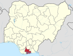
Oyigbo also known as Obigbo is a Local Government Area located in Rivers State, Nigeria. It is a town, [1] 30 kilometers from the Port city of Port Harcourt, 25km from the city of Aba. It's predominantly inhabited by the Asa people an indigenous Igbo people who are also found in Ukwa west L.G.A in Abia state and the Ndoki people who are also found in Ukwa East L.G.A of Abia state and Ukanafun L.G.A of Akwa ibom state
Sir Precious Oforji was elected Chairman of the Oyigbo LGA in 2008. [2] EZE Mike Nwaji was enthroned as the crowned traditional king of Obigbo in 1998. [3] The towns and villages in Oyigbo Local Government area include : Obigbo district; Asa, Komkom, Obeama, Obigbo, while for the Ndoki district they include Afa Uku, Afam, Afam Nta, Azusogu, Egberu, Mgboji, Mrihu, Obeakpu, Obeta, Obumku,Okoloma, Okponta, Umuagbai, Umuosi. [3]
Owing to the geographical location of Oyigbo, there was a contention between the neighboring States, Rivers State and Abia State as to which of the States should rightfully own the Oyigbo Local Government Area. After several deliberations between the two States involved, there was an agreement that Oyigbo should remain as a part of Rivers State. [4]
Shell Petroleum Development Company (SPDC) operates an oil well in the LGA. [5] Eastern Network Gas Pipeline (Alscon pipeline) passes through Oyigbo in the north. [6] : 5 Nigerian National Petroleum Corporation, NNPC and the Rivers State Government under Gov. Rotimi Chibuike Amaechi pledged to work together to restore production activities at the Shell Petroleum Development Company, SPDC operated at Oyigbo Gas Plant. [7] On November 1, 2013, citing considerable health and safety risk to people, Shell Petroleum Development Company of Nigeria Ltd (SPDC), JV shut down Oyigbo gas plant over encroachment on the right-of-way of gas pipelines. [8]
On June 28, 2015, SPDC JV's announced that its Afam VI located in Okoloma village of Oyigbo had delivered 20 million MWh of electricity into the national grid and created over 150 jobs. [9]
Oyigbo LGA is rich in deposits of crude oil and natural gas with several oil mining corporations operating in the area which contribute to the economy. [10] The LGA is a hub for fishing with the rivers and tributaries that constitute the area's hydrosphere being rich in seafood [ citation needed ]. Other notable economic activities in Oyigbo LGA include farming, trade, and crafts making. [11]
Oyigbo accommodates a number of businesses in her locality. A good number of establishments owned by individuals and government can be found in Oyigbo. [12] These establishments include but are not limited to hotels, industries, commercial shops, among others.
The average temperature of Oyigbo LGA is 25 degrees Celsius, and the region is home to numerous rivers and tributaries. According to estimates, the LGA has an average humidity level of 79% and an average wind speed of 12 km/h. [13] [14] [15]
Aba is a city in southeastern Nigeria and the commercial centre of Abia State. Upon the creation of Abia State in 1991, the old Aba township was divided into two local government areas, being Aba South and Aba North, while the suburban neighborhood of what was then known as Obioma Ngwa L.G.A. was divided into three L.G.A.s for administrative convenience. Aba South is the main city centre of Aba and Abia State at large, being located on the Aba River. Aba is made up of many villages such as Aba-Ukwu, Eziukwu-Aba, Obuda-Aba, Umuokpoji-Aba and other villages that have been merged for administrative convenience. Aba was established by the Ngwa clan of the Igbo people in Nigeria as a market town. Later, a military post was placed there by the British colonial administration in 1901. It lies along the west bank of the Aba River and is at the intersection of roads leading to Port Harcourt, Owerri, Umuahia, Ikot Ekpene, and Ikot-Abasi. The city became a collection point for agricultural products following construction of a British-made railway running through it to Port Harcourt. Aba is a major urban settlement and commercial centre in its region, which is surrounded by small villages and towns. The indigenous people of Aba are the Ngwa. Aba is well known for its craftsmen and is the most populous city in southeastern Nigeria. As of 2016, Aba had an estimated population of 2,534,265, making it the biggest city in South Eastern Nigeria.
Nigeria is the second largest oil and gas producer in Africa. Crude oil from the Niger Delta basin comes in two types: light, and comparatively heavy – the lighter has around 36 of API gravity while the heavier has 20–25 of API gravity. Both types are paraffinic and low in Sulphur. Nigeria's economy and budget have been largely supported from income and revenues generated from the petroleum industry since 1960. Statistics as at February 2021 shows that the Nigerian oil sector contributes to about 9% of the GDP of the nation.
Shell Nigeria is the common name for Shell plc's Nigerian operations carried out through four subsidiaries—primarily Shell Petroleum Development Company of Nigeria Limited (SPDC). Royal Dutch Shell's joint ventures account for more than 21% of Nigeria's total petroleum production.
Environmental issues in the Niger Delta are caused by its petroleum industry. The delta covers 20,000 km2 (7,700 sq mi) within wetlands of 70,000 km2 (27,000 sq mi) formed primarily by sediment deposition. Home to 20 million people and 40 different ethnic groups, this floodplain makes up 7.5% of Nigeria's total land mass. It is the largest wetland and maintains the third-largest drainage basin in Africa. The Delta's environment can be broken down into four ecological zones: coastal barrier islands, mangrove swamp forests, freshwater swamps, and lowland rainforests. Fishing and farming are the main sources of livelihoods for majority of her residents.
Tai is a Local Government Area (LGA) of Rivers State in Nigeria. It covers an area of 159 km2 and at the 2006 Census it had a population of 117,797. It is part of the Okrika/Oyigbo/Tai/Eleme constituency of the Nigerian Senate, represented since April 2007 by George Thompson Sekibo. Tai local government headquartersis situated at Sakpenwa Christianity and traditionalism are widely practiced in the area and little Islamic religion In the April 2007 elections the Tai LGA recorded an implausible 99.6% turnout for the Governorship election. Celestine Omehia of the Rivers State People's Democratic Party was at first declared winner, but his election was later annulled and Rotimi Amaechi, also of the PDP, was declared governor. In February 2009, the Chairman of Tai Local Government Area was Barry Mpigi.
Osisioma Ngwa is a Local Government Area of Abia state of Nigeria. Its headquarters are located in Osisioma town.
Ukwa East is a Local Government Area located in Abia State, Nigeria. Its headquarters is in the town of Akwete. Ukwa East is bordered by Akwa Ibom State and Rivers States.
Ukwa West is a Local Government Area in Abia State, Nigeria. Its headquarters is in the town of Oke Ikpe.
Oloibiri Oilfield is an onshore oilfield located in Oloibiri in Ogbia LGA of Bayelsa State, Nigeria, and was the first to be discovered in that country. It is located about 45 miles (72 km) east of Port Harcourt in the Niger Delta. Oloibiri field is about 13.75 square kilometres (5.31 sq mi) and lies in a swamp within OML 29
Taleveras is an African business conglomerate, privately owned with business interests in energy and infrastructure, oil and gas exploration, production, trading and supply, power and construction. Taleveras’ offices are located in London, Geneva, Abuja, Lagos, Abidjan, Cape Town and Dubai.
Izombe in the northeast of Niger Delta is an oil town in Njaba River basin, Imo State Southeastern Nigeria.
Aiteo is Africa’s largest privately-owned integrated energy company. It is involved in various aspects of the energy sector, including oil and gas exploration, production, refining, and marketing. Aiteo operates in West and Southern Africa.
OML 29 is also known as Oil Mining Licence 29. Oil Mining Licence OML is one of the two types of licences issued to oil producers in Nigeria "with validity periods ranging from 5 to 20 years respectively." OML29 is a large block located in the southeastern Niger Delta containing 11 oil and gas fields. OML29 stretches over an area of 983 square kilometres. It includes the Nembe Oil Field, Santa Barbara Oil Field and Okoroba Oil Fields. It also include related facilities like the Nembe Creek Trunk Line NCTL. A 100 kilometres long pipeline with a capacity of 600 thousand barrels per day.
The Niger Delta Avengers (NDA) is a militant group in the Niger Delta region of Nigeria. The group publicly announced their existence in March 2016.
The Niger Delta Greenland Justice Mandate (NDGJM) is a militant group operating in Nigeria's Niger Delta region. The group was founded on August 2, 2016 in Delta State and is composed mainly of ethnic Urhobos, and a fairly large number of members belonging to the Isoko ethnic group.
Umuagbai town is one of the major settlements of the Ndoki people. These towns numbering 54 in total are grouped into seven clans they are Umu Ihueze 1, Umu Ihueze II, Obohia, Ikwueke, Umu Okobo, Ohuru and Mkporobo and Ikwu-Orie-Ato. Umuagbai town is located presently in Oyigbo Local Government Area of Rivers State and is part of the Umu Okobo clan. Umuagbai town is one of the larger communities within the local government area and constitutes an entire Ward on its own; Ward Six. Umuagbai town shares boundary with Akwete in Abia State and the two communities has strong cultural affinities. It is bounded to the south by Azuogu and to the north by Mgboji all in Oyigbo L.G.A while its boundary in the west is to Okwali in Khana Local Government of Rivers State.
Egbema is a town in Ohaji/Egbema, Local Government Areas of Imo State, Nigeria.
Afam is a town in Oyigbo Local Government Area, Rivers State, Nigeria. The headquarter of Oyigbo is in Afam.
Igbo-Etche is one of the towns in Etche Local Government Area of Rivers State.
Ndoki also known as Ọkwa are a tribe of Igbo people that are located at the hinterland of Igboland and coastal region of Bonny and Opobo.