
The Ijaw people, otherwise known as the Ijo people, are an ethnic group found in the Niger Delta in Nigeria, with significant population clusters in Bayelsa, Delta, and Rivers. They are also in Edo, Ondo, and small parts of Akwa Ibom., occupying six Nigerian states. Many are found as migrant fishermen in camps as far west as Sierra Leone, Ghana and as far east as Gabon. As of 2023, Nigeria's Ijaw population is estimated at approximately over 15 million, accounting for around 6.9% of the country's 223 million people, positioning them as the fourth largest ethnic group in Nigeria. The Ijaws are the most populous tribe inhabiting the Niger Delta region, and one of the world's most ancient peoples.

Rivers State, also known as Rivers, is a state in the Niger Delta region of southern Nigeria. Formed on 27 May 1967, when it was split from the former Eastern Region, Rivers State borders include Imo and Anambra to the north, Abia and Akwa Ibom to the east, and Bayelsa and Delta to the west.The State capital, Port Harcourt, is a metropolis that is considered to be the commercial center of the Nigerian oil industry.
The Defaka are a small ethnic group of south-eastern Nigeria, numbering fewer than a thousand people. They live in the eastern part of the Niger Delta, Rivers State, Bonny District; part of them in the Defaka ward of Nkoroo town in close relationship with the Nkoroo people, and another part of them on the isolated island of Iwoma Nkoro, near Kono. Present neighbours of the Defaka, apart from the Nkoroo people, are: at Iwoma, the Ogoni people, and to the east, the Obolo. The Defaka have a less cordial relationship with these peoples than with the Nkoroo.
Bonny is a traditional, coastal town and a Local Government Area (LGA) in Rivers State in Southern Nigeria, on the Bight of Bonny. It is also the capital of the Kingdom of Bonny.
Oguta is a town on the east bank of Oguta Lake in Imo State of southeastern Nigeria.
Opobo is a community in Rivers state, South South region of Nigeria. The kingdom was founded in 1870 by Jubo Jubogha, popularly known as JaJa, a former Igbo slave who was absorbed into the pre-existing Ibani Ijaw culture. The native language of Opobo is the Ibani language, a dialect of Ijaw that is closely related to Kalabari.
Bonny Island is a local government situated at the southern edge of Rivers State in the Niger Delta region of Nigeria near Port Harcourt. Ferries are the main form of transport, though recently an airstrip has been built and it’s fully functional - with flights from Lagos, Abuja and Port Harcourt respectively to and from the island. The local dialect spoken in Bonny Island are Igbo language and Ibani language.
The Izonlanguages, otherwise known as the Ịjọ languages, are the languages spoken by the Izon people in southern Nigeria.

The Kalabari are a sub-group of the Ijaw people living in the eastern Niger Delta region of Nigeria. Originally, they were known as the Awome. The name Kalabari was derived from their ancestor Perebo Kalabari who was a son of Meinowei. Their original settlement was spelt as Calabar by the Portuguese which was pronounced Kalabari. This settlement (town) was abandoned as the people moved to other fishing settlements. Portuguese settlers continued to maintain the name Calabari which became surrounded by the Efik people of Duke town. When the British came the word Calabari was pronounced as Calabar (Kalaba) instead of Kalabari. At this time the original Ijoid Kalabaris had moved to a new location which became the new Calabar territory since the old Calabar is occupied by different people. Old Calabar became an Efik town with time which has the name Calabar.
The Obolo people, also known as the Andoni or Doni, is an ethnic group in the Niger Delta region of Nigeria. Obolo people are primarily found in Rivers State and Akwa Ibom State. They are also present in the states of Bayelsa, Cross River, Abia, and Enugu.
The Bille tribe of the Ijaw people lives in central Rivers State, Nigeria. Bille is one of the Ancient Ijaw Kingdoms in the Eastern Niger Delta region. The tribal seat is the town of Bille. Bille Town is the headquarters of the Ancient Bille Kingdom founded by Queen Ikpakiaba in the 9th century. It is a choice place for tourism because of its rich unadulterated culture of the Ijaw people. The people are friendly, accommodating and fun loving. Bille is one of the places on earth where the dignity of womanhood is upheld. Democracy is enshrined in its culture and therefore there is a practice of equal rights.
The Ibani people are of Ijaw ethnic group who live along with the Ijaw speaking people in the Bonny and Opobo areas of Rivers State, Nigeria, on the Atlantic coast. Bonny town is the tribal seat of the Ibani which is located on the bight of Bonny River. Ibani language is spoken predominantly by residents of Bonny and Opobo. Bonny's development was also shaped by the tribe's close interaction with European traders.

The Oron people are a multi-ethnic tribal grouping that make up the Akpakip Oro or Oron Nation. The Oron people (Örö) are located primarily in southern Nigeria in the riverine area of Akwa Ibom State and Cross River State and in Cameroon. Akpakip Oro are regarded as an ancient warrior people, speaking the Oron (Oro) language which is in the Cross River language family of the Benue–Congo languages. They are ancestrally related to the Efik people of the Cross River State, the Ibeno and Eastern Obolo in Akwa Ibom, the Andoni people in Rivers State, Ohafia in Abia State and the Balondo-ba-Konja in the Congo.
The Nkoro tribe' of the Ijaw people lives in southeastern Rivers State, Nigeria. Nkoro settlements include: Nkoro, Ayama, Dema, The cultural traditions have been influenced by its proximity to the Andoni, the Bonny. The Nkoro dialect is a dialect of the Ijaw language.
The Kingdom of Bonny, otherwise known as Grand Bonny, is a traditional state based on the town of Bonny in Rivers State, Nigeria. In the pre-colonial period, it was an important slave trading port, later trading palm oil products. During the 19th century the British became increasingly involved in the internal affairs of the kingdom, in 1886 assuming control under a protectorate treaty. Today the King of Bonny has a largely ceremonial role.
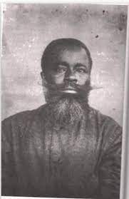
Chief Oko Jumbo was an Ijaw chief of slave descent in the Kingdom of Bonny, a state in the Niger Delta, now part of Rivers State, Nigeria. For many years in the 19th century he was the effective ruler of Bonny. Though not the king in Bonny, and Warribo was the technical head of the Fubara Manilla Pepple House, "Oko Jumbo and Ja Ja were looked upon by every one as being the rulers of Bonny."
John Ikuru (1877–1947) was the son of king Ikuru Efuya, founder of Ikuru Town and Madam Obiringene of Opobo; his mother came from Ekede. He was born in 1877 in Ikuru Town, and had his primary school education at St. Paul's School, Opobo/Nkoro, from 1887 to 1895, and secondary school education at the Wesley Boys’ High School, in Lagos. At that time, Christianity was already sweeping through the entire Western Region of now Nigeria and the Niger Delta, through the evangelistic activities of the Church Missionary Society with Bishop Ajayi Crowther as the pioneer Missionary. So, trained in Lagos, John Ikuru embraced Christianity and became exposed to Christian ethics and philosophy.
Harold Jenewari Dappa-Biriye was a Nigerian politician who was a former chairman of the Niger Delta Congress and was known for his advocacy of minority rights in Nigeria. He was also a former chairman of the Nigeria National Council of Arts and Council and it was during his tenure, the first festival (NAFEST) was held. An arts patron, he promoted events such as Bonny war canoe regattas.
The Unyeada Kingdom, sometimes referred to as "Ayanda" a corrupted version of Unyeada, some literal version interpreted it as "prowess of Edabiri". Unyeada is an ancient riverine settlement (Kingdom) located in western part of Obolo Land, administratively in Andoni Local Government Area of Rivers State, Nigeria. Situated in the south of Ogoni tribe and Kingdom of Bonny to the west and Eastern Obolo to the east. Unyeada territory stretches from Iburubu Sea near the mouth of Andoni River to Okwan Obbu or Imo River.
