
Sin Cowe Island9°53′7″N114°19′47″E, also known as Sinh Ton Island ; Rurok Island ; Mandarin Chinese: 景宏島/景宏岛; pinyin: Jǐnghóng Dǎo, is an island in the Spratly Islands in the South China Sea. With an area of 8 hectares, it is the seventh largest Spratly island and the third largest of those occupied by Vietnam. It has a fringing reef which is above water at low tide.

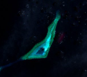
The Johnson South Reef skirmish took place on 14 March 1988 between military forces of the People's Republic of China and Vietnam, on the Johnson South Reef in the Union Banks region of the Spratly Islands, in the South China Sea.

Johnson South Reef, also known in Mandarin Chinese: 赤瓜礁; pinyin: Chìguā Jiāo; Mabini Reef ; Vietnamese: Đá Gạc Ma), is a reef in the southwest portion of the Union Banks in the Spratly Islands of the South China Sea. It is controlled by the People's Republic of China (PRC), but its ownership is disputed and also claimed by the Philippines, Taiwan (ROC), and Vietnam.

Subi Reef, also known as Zamora Reef ; Zhubi Reef ; Vietnamese: đá Xu Bi, is an atoll in the Spratly Islands of the South China Sea located 26 km (16 mi) southwest of Philippines' Pag-asa island Thitu Island under the municipality of the Kalayaan Island Group, Palawan province as claimed by Philippines. It is occupied by China (PRC), and claimed by Taiwan (ROC) and Vietnam. According to the claims of the PRC, it currently falls under the de facto jurisdiction of Nansha islands, Sansha city, Hainan province, China. But under the clauses of the UNCLOS, of which the PRC is also a signatory, the international law only the Philippines has the maritime rights to exploit its resources or build structures, as it is within the continental shelf of the coastal country.

Mischief Reef, also known as Panganiban Reef, is a low tide elevation (LTE) reef/atoll surrounding a large lagoon in the SE of Dangerous Ground in the east of the Spratly Islands in the South China Sea. It is located 250 kilometres (130 nmi) west of Palawan Island of the Philippines. Administratively, it belonged to the Kalayaan Islands municipality of the province of Palawan. It is also under the de facto jurisdiction of Nansha islands, Sansha City, Hainan province, China. Activities by the People's Republic of China (PRC) in the mid-2010s have created a large artificial island on the atoll including an approximately 2,700-metre (8,900 ft) runway and associated airfield.

Ladd Reef is a Vietnam-controlled reef in the Spratly group of islands, South China Sea. China (PRC) and Taiwan (ROC) are also claimants of the reef. Like Spratly Island, Ladd Reef lies to the west of the Philippines-defined "Kalayaan Islands" claim area.

Trường Sa is an island district of Khánh Hòa province in the South Central Coast region of Vietnam. It was established on the basis of the Spratly Islands, which is also claimed wholly or in part by Brunei, China, Malaysia, the Philippines and Taiwan. According to the 2009 census, the district has a population of 195 people.

Dangerous Ground is a large area in the southeast part of the South China Sea characterized by many low islands and cays, sunken reefs, and atolls awash, with reefs often rising abruptly from ocean depths greater than 1,000 metres (3,300 ft).

The Tizard Bank, 10°15′N114°30′E is a partially sunken atoll and one of the significant maritime features of the north-western part of the Spratly Islands. It is claimed by Vietnam, China, and Taiwan, and various parts of it are occupied by these states.
Irving Reef, also known as Balagtas Reef, is a coral atoll in the Spratly Islands, South China Sea. It is occupied by the Philippines as part of Kalayaan, Palawan, and is also claimed by the People's Republic of China, the Republic of China (Taiwan) and Vietnam.
Hughes Reef is a reef in Union Banks in the Spratly group of islands, South China Sea claimed by the PRC (China), the ROC (Taiwan), the Philippines, Malaysia, and Vietnam. It is only above water at low tide.

Collins Reef, also known as Johnson North Reef/Johnson Reef North; Vietnamese: Đá Cô Lin; Roxas Reef ; Mandarin Chinese: 鬼喊礁; pinyin: Guǐhǎn Jiāo, is a Vietnamese occupied and controlled reef and the westernmost feature of Union Banks Atoll near the centre of Dangerous Ground in the Spratly islands in the South China Sea. It is also claimed by China (PRC), Taiwan (ROC), and the Philippines.

Sabina Shoal, also known as Escoda Shoal ; Mandarin Chinese: 仙賓礁/仙宾礁; pinyin: Xiānbīn Jiāo; Vietnamese: Bãi Sa Bin, is an atoll in the NE of Dangerous Ground in the Spratly Islands. The Philippines puts it under the jurisdiction of Brgy. Pag-asa, Kalayaan, Palawan. It is also claimed by the People's Republic of China, and the Republic of China (Taiwan) and Vietnam.

The London Reefs are located between 8°49′N112°12′E and 8°56′N112°52′E in the Spratly Islands of the South China Sea.
North Danger Reef is one of the seven major reefs / banks / etc. in the Spratly Islands area of the South China Sea. It is the most North Western of the features of the Spratly Islands, located to the NW of Dangerous Ground.

Whitsun Reef, also known as Whitson Reef, Whitsum Reef, and Julian Felipe Reef, is a reef at the northeast extreme limit of the Union Banks in the Spratly Islands of the South China Sea. It is the largest reef of the Union Banks.

Grierson Reef ; Sin Cowe East Island (Vietnamese: Đảo Sinh Tồn Đông); Mandarin Chinese: 染青沙洲; pinyin: Rǎnqīng shāzhōu, is a cay on the eastern part of the Union Banks of the Spratly Islands in the South China Sea. The island has been occupied by Vietnam since 1978. It is also claimed by China (PRC), the Philippines, Vietnam, and Taiwan (ROC).

Pearson Reef, as known as Phan Vinh Island ; Mandarin Chinese: 毕生礁; pinyin: Bìshēng jiāo, is a atoll on the Spratly Islands in the South China Sea. The atoll has been occupied by Vietnam since 1978. It is also claimed by China (PRC), the Philippines, Vietnam, and Taiwan (ROC).

Lansdowne Reef ; Len Đao Reef ; Mandarin Chinese: 琼礁; pinyin: Qióng jiāo, is a cay on the southern part of the Union Banks of the Spratly Islands in the South China Sea. The island has been occupied by Vietnam since 1988. It is also claimed by China (PRC), the Philippines, Vietnam, and Taiwan (ROC).


