West Sand

Last updated
ParacelIslands.png

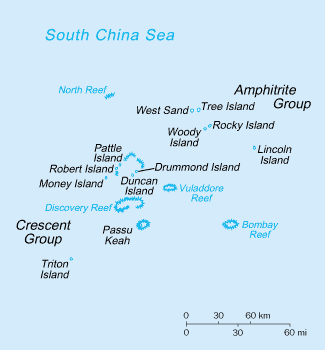
West Sand 16°58′39″N112°12′43″E / 16.97750°N 112.21194°E / 16.97750; 112.21194 (Chinese :西沙洲; pinyin :Xīshā-zhōu; Vietnamese : Cồn Cát Tây) is a sand cay located in the northwest of the Amphitrite Group of the Paracel Islands in the South China Sea. [1] It is approximately 4 nautical miles (7.4 km) west of Tree Island.

West Sand is administered by the People's Republic of China. Being a part of the disputed Paracel Islands, the entity is also claimed by the Republic of China (Taiwan) and Vietnam. [2] [3]

In July 2014, the PRC announced an investment plan of 18 million yuan (about 2.92 million U.S. dollars) that "will be used to build desalination systems and grow trees on Xishazhou Island in the hope of turning the island into a new oasis". [4] In April 2017, Xinhua published pictures of the current state of the forestation project, with trees going on most of the island. [5]

Related Research Articles

<span class="mw-page-title-main">Paracel Islands</span> Islands in the South China Sea

The Paracel Islands, also known as the Xisha Islands and the Hoàng Sa Archipelago, are a disputed archipelago in the South China Sea.

<span class="mw-page-title-main">Spratly Islands</span> Disputed archipelago in the South China Sea

The Spratly Islands are a disputed archipelago in the South China Sea. Composed of islands, islets, cays, and more than 100 reefs, sometimes grouped in submerged old atolls, the archipelago lies off the coasts of the Philippines, Malaysia, and southern Vietnam. Named after the 19th-century British whaling captain Richard Spratly who sighted Spratly Island in 1843, the islands contain less than 2 km2 of naturally occurring land area, which is spread over an area of more than 425,000 km2 (164,000 sq mi).

<span class="mw-page-title-main">South China Sea</span> Marginal sea of the Western Pacific Ocean

The South China Sea is a marginal sea of the Western Pacific Ocean. It is bounded in the north by the shores of South China, in the west by the Indochinese Peninsula, in the east by the islands of Taiwan and northwestern Philippines, and in the south by the Indonesian islands of Borneo, eastern Sumatra and the Bangka Belitung Islands, encompassing an area of around 3,500,000 km2 (1,400,000 sq mi). It communicates with the East China Sea via the Taiwan Strait, the Philippine Sea via the Luzon Strait, the Sulu Sea via the straits around Palawan, and the Java Sea via the Karimata and Bangka Straits. The Gulf of Thailand and the Gulf of Tonkin are also part of South China Sea.

<span class="mw-page-title-main">Woody Island (South China Sea)</span> China-controlled disputed Paracel Island in the South China Sea

Woody Island, also called Yongxing Island by China and Taiwan and Phú Lâm Island by Vietnam, is the largest of the Paracel Islands in the South China Sea (SCS), with an area of 2.1 square kilometres (0.81 sq mi). As of 2014, it has a population of almost 1,500, with roads, banks and an air strip.

<span class="mw-page-title-main">Taiping Island</span> Disputed island in the South China Sea

Taiping Island, also known as Itu Aba, and various other names, is the largest of the naturally occurring Spratly Islands in the South China Sea. The island is elliptical in shape being 1.4 kilometres (0.87 mi) in length and 0.4 kilometres (0.25 mi) in width, with an area of 46 hectares. It is located on the northern edge of the Tizard Bank. The runway of the Taiping Island Airport is easily the most prominent feature on the island, running its entire length.

<span class="mw-page-title-main">Battle of the Paracel Islands</span> Naval battle

The Battle of the Paracel Islands was a military engagement between the naval forces of China and South Vietnam in the Paracel Islands on January 19, 1974. The battle was an attempt by the South Vietnamese navy to expel the Chinese navy from the vicinity. The confrontation took place towards the end of the Vietnam War.

<span class="mw-page-title-main">Loaita Island</span>

Loaita Island also known as Kota Island, with an area of 6.45 hectares -- is the tenth largest of the naturally-occurring Spratly Islands, and the fifth largest of the Philippine-occupied islands. It is located just to the west of the northern part of Dangerous Ground, and is 22 miles (35 km) southeast of Philippine-occupied Thitu Island (Pag-asa) and 22 miles (35 km) north-northeast of Taiwan-occupied Itu Aba Island.

<span class="mw-page-title-main">Tree Island, South China Sea</span> Village-level division in Hainan, China

For the "Tree Island" in Tuen Mun District, New Territories, Hong Kong, see Pak Chau.

<span class="mw-page-title-main">Namyit Island</span> Island

Namyit Island, also known as Vietnamese: Đảo Nam Yết; Binago Island ; Mandarin Chinese: 鴻庥島/鸿庥岛; pinyin: Hóngxiū Dǎo, is the third-largest island on Tizard Bank in the northwest of the Spratly Islands in South China Sea. With an area of 5.3 hectares, it is the twelfth-largest naturally-occurring Spratly island, and the fifth-largest among the Vietnamese-administered islands. The island is also claimed by China (PRC), the Philippines, and Taiwan (ROC).

<span class="mw-page-title-main">Sansha</span> Prefecture-level city in Hainan, Peoples Republic of China

Sansha City is a prefecture-level city under the Hainan province of the People's Republic of China (PRC), and is the southernmost and least populated prefecture in China, with the smallest land area but the largest maritime territory. The city's seat is located on Yongxing Island in the South China Sea, and administers several island groups, atolls, seamounts and a number of other ungrouped maritime features within the nine-dash line, although the PRC's de facto control over the area varies. The name "Sansha", literally meaning "three sands", refers to the three archipelago districts of Xisha, Zhongsha and Nansha.

<span class="mw-page-title-main">Spratly Island</span> One of the Spratly Islands in the South China Sea

Spratly Island, also known as Storm Island, is the fourth largest of the naturally occurring Spratly Islands in the South China Sea with an area of 15 hectares, and the largest of the Vietnamese-administered Spratly islands.

<span class="mw-page-title-main">Sand Cay</span> Island

Sand Cay10°22′30″N114°28′48″E, also known as Bailan Island ; Son Ca Island ; Mandarin Chinese: 敦謙沙洲/敦谦沙洲; pinyin: Dūnqiān Shāzhōu, is a cay on the north edge of the Tizard Bank of the Spratly Islands in the South China Sea. With an area of 7 hectares, it is the ninth largest, and the fourth largest former Vietnamese-administered, of the Spratly Islands. The island has been occupied by Vietnam since 1974,. It is also claimed by China (PRC), the Philippines, Vietnam, and Taiwan (ROC).

<span class="mw-page-title-main">Spratly Islands dispute</span> Territorial dispute between China and Southeast Asian countries.

The Spratly Islands dispute is an ongoing territorial dispute between China, the Philippines, Taiwan, Malaysia, Vietnam, and Brunei, concerning "ownership" of the Spratly Islands, a group of islands and associated "maritime features" located in the South China Sea. The dispute is characterized by diplomatic stalemate and the employment of military pressure techniques in the advancement of national territorial claims. All except Brunei occupy some of the maritime features.

<span class="mw-page-title-main">Money Island, Paracel Islands</span> Island in the South China Sea

<span class="mw-page-title-main">Territorial disputes in the South China Sea</span>

Territorial disputes in the South China Sea involve conflicting island and maritime claims in the region by several sovereign states, namely the People's Republic of China (PRC), Taiwan, Brunei, Malaysia, the Philippines, and Vietnam. The disputes involve the islands, reefs, banks, and other features of the South China Sea, including the Spratly Islands, Paracel Islands, Scarborough Shoal, and various boundaries in the Gulf of Tonkin. The waters near the Indonesian Natuna Islands, which some regard as geographically part of the South China Sea, are disputed as well. Maritime disputes also extend beyond the South China Sea, as in the case of the Senkaku Islands and the Socotra Rock, which lie in the East China Sea.

<span class="mw-page-title-main">Hoàng Sa district</span> District in South Central Coast, Vietnam

Hoàng Sa is an island district of Da Nang in the South Central Coast region of Vietnam. It covers an area of 305 km2 (118 sq mi) of the Paracel Islands, including these main features: Pattle Island, North Reef, Robert Island, Discovery Reef, Passu Keah, Triton Island, Tree Island, North Island, Middle Island, South Island, Woody Island, Lincoln Island, Duncan Island, Bombay Reef, Observation Bank, West Sand, Vuladdore Reef and Pyramid Rock.

The Hai Yang Shi You 981 standoff, also known as the 2014 China-Vietnam oil rig crisis, refers to the tensions between China and Vietnam arising from the Chinese state-owned China National Offshore Oil Corporation moving its Hai Yang Shi You 981 oil platform to waters near the disputed Paracel Islands in South China Sea, and the resulting Vietnamese efforts to prevent the platform from establishing a fixed position. According to an announcement by the Hainan Maritime Safety Administration of China, the drilling work of the Hai Yang Shi You 981 would last from May 2 to August 15, 2014. On July 15, China announced that the platform had completed its work and withdrew it fully one month earlier than originally announced.

<span class="mw-page-title-main">Yagong Island</span> Village-level division in Hainan, China

Yagong Island is an island in the Crescent Group of the Paracel Islands, in the South China Sea. It is also known as "He Duck",, due to its shape. It is located a few hundred metres southwest of Observation Bank in the northeast of the Crescent Group.

<span class="mw-page-title-main">North Danger Reef</span>

North Danger Reef is one of the seven major reefs / banks / etc. in the Spratly Islands area of the South China Sea. It is the most North Western of the features of the Spratly Islands, located to the NW of Dangerous Ground.

<span class="mw-page-title-main">Timeline of the South China Sea dispute</span>

The article covers events that are related to the South China Sea dispute.

References

  1. GEOnet Names Server (GNS)
  2. 19.海南諸島礁名稱 (in Chinese). Department of Social Affairs, Ministry of the Interior (Republic of China). Retrieved 20 March 2013.
  3. "Huyện đảo Hoàng Sa" (in Vietnamese). Da Nang Portal. Retrieved 20 March 2013.
  4. "China Focus: South China islands see green transformation". news.xinhuanet.com. 30 July 2014. Archived from the original on September 13, 2014. Retrieved 13 September 2014.
  5. Beautiful scenery of south China's Sansha City. Retrieved 2017-04-27.

16°58′00″N112°12′00″E / 16.96667°N 112.20000°E / 16.96667; 112.20000