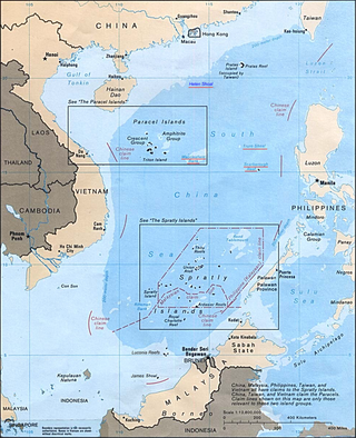
The South China Sea Islands consist of over 250 islands, atolls, cays, shoals, reefs and seamounts in the South China Sea. The islands are mostly low and small, and have few inhabitants. The islands and surrounding seas are subject to overlapping territorial claims by the countries bordering the South China Sea.
Pratas Island, also known as the Tungsha Islands or the Dongsha Islands, is a coral island situated in the northern part of the South China Sea administered as part of Cijin District, Kaohsiung, Taiwan. It is located about 170 nautical miles southeast of Hong Kong. It has an area of about 240 hectares, including 64 hectares of lagoon, and is the largest of the South China Sea Islands. It is the location of the Dongsha Airport.
The Zhongsha Islands is a Chinese term for a collection of two skerries, many entirely submerged banks, seamounts, and shoals in the South China Sea. There are in fact, no islands in the Macclesfield Bank, the main part of Zhongsha. The Scarborough Shoal, which consists of two skerries, is not contiguous with the Macclesfield Bank but Chinese sources treat them as one chain of geographical features. The whole of the region is claimed by both the PRC and the ROC, and various bits of the eastern parts are claimed by the Philippines. No country has constant control of the whole region, and there are disputes - for example, see Scarborough Shoal standoff.

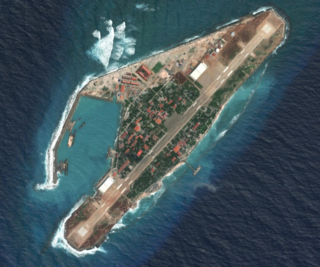
Woody Island, also called Yongxing Island by China and Taiwan and Phú Lâm Island by Vietnam, is the largest of the Paracel Islands in the South China Sea (SCS), with an area of 2.1 square kilometres (0.81 sq mi). As of 2014, it has a population of almost 1,500, with roads, banks and an air strip.
James Shoal is an underwater shoal (bank) in the South China Sea, with a depth of 22 metres (72 ft) below the surface of the sea, located about 45 nautical miles off the Borneo coast of Malaysia. It is claimed by Malaysia, the People's Republic of China, and the Republic of China (Taiwan). The shoal and its surrounds are administered by Malaysia.
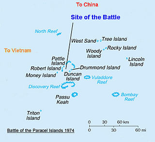
The Battle of the Paracel Islands was a military engagement between the naval forces of China and South Vietnam in the Paracel Islands on January 19, 1974. The battle was an attempt by the South Vietnamese navy to expel the Chinese navy from the vicinity. The confrontation took place towards the end of the Vietnam War.

Sheshan Island is located 35 km (22 mi) east of Chongming Island, in the estuary of the Yangtze River. The area is 0.037 km2 (0.014 sq mi).
Haijiao (海礁), also known as Tong Island (童岛), Taibujiao (泰簿礁) or Taijiao (泰礁), is located at 30°44'6"N, 123°9'24"E in the northeast corner of the Zhoushan Islands and belongs to Shengsi County of Zhoushan city. The name Haijiao literally means 'the ocean reef', and its generally accepted cartographic name of Taijiao literally means 'the extreme reef', a reference to its isolated position on the edge of China's maritime territory. It is a baseline point of China's territorial seas.
Dongnanjiao Island("东南礁") is located in the northeast corner of Zhoushanqundao ,76 km from Shengsi County, and is part of the Shengsi County of Zhoushan city. Dongnanjiao is the baseline point of the Chinese territorial sea.
Liangxiongdiyu Island ("两兄弟屿") is located 67 km northeast of Shenjiamen. It belongs to the Dongji Town of Zhoushan city. Liangxiongdiyu is the baseline point of the Chinese territorial sea. 2006, The stele of "Chinese territorial sea baseline point" erected.

Triton Island is the westernmost and southernmost of the Paracel Islands in the South China Sea. It is located on the southwest corner of Triton Reef and has an area of 7 hectares above sea-level. The reef including the island measures about 120 hectares in area. The island is administered by the People's Republic of China, and is also claimed by the Republic of China (Taiwan) and Vietnam.

Bombay Reef is an atoll of the Paracel Islands. In Chinese, the reef is alternatively known as "Pengbojiao", or "Qilianyu" along with six other islands close by.

Sansha City is a prefecture-level city under the Hainan province of the People's Republic of China (PRC), and is the southernmost and least populated prefecture in China, with the smallest land area but the largest maritime territory. The city's seat is located on Yongxing Island in the South China Sea, and administers several island groups, atolls, seamounts and a number of other ungrouped maritime features within the nine-dash line, although the PRC's de facto control over the area varies. The name "Sansha", literally meaning "three sands", refers to the three archipelago districts of Xisha, Zhongsha and Nansha.
Spratly Island, also known as Storm Island, is the fourth largest of the naturally occurring Spratly Islands in the South China Sea with an area of 15 hectares, and the largest of the Vietnamese-administered Spratly islands.

Johnson South Reef, also known in Mandarin Chinese: 赤瓜礁; pinyin: Chìguā Jiāo; Mabini Reef ; Vietnamese: Đá Gạc Ma), is a reef in the southwest portion of the Union Banks in the Spratly Islands of the South China Sea. It is controlled by the People's Republic of China (PRC), but its ownership is disputed and also claimed by the Philippines, Taiwan (ROC), and Vietnam.

Ladd Reef is a Vietnam-controlled reef in the Spratly group of islands, South China Sea. China (PRC) and Taiwan (ROC) are also claimants of the reef. Like Spratly Island, Ladd Reef lies to the west of the Philippines-defined "Kalayaan Islands" claim area.

Chengqu, is a district of Shanwei, Guangdong Province, People's Republic of China.
West Sand16°58′39″N112°12′43″E is a sand cay located in the northwest of the Amphitrite Group of the Paracel Islands in the South China Sea. It is approximately 4 nautical miles (7.4 km) west of Tree Island.
Luci Island (Chinese: 鸬鹚岛 / 鸬鹚屿; pinyin: Lúcí Dǎo/Yǔ/Xù; Wade–Giles: Lu2-tzʻŭ2 Tao3/Yü3/Hsü4; lit. 'cormorant island') (also Loutz Island (Lu-tzʻu, Lucih) and Lusi Island (Lusih, Lu-ssu) (Chinese: 鷺鷥島; pinyin: Lùsī Dǎo; Wade–Giles: Lu4-ssŭ1 Tao3; lit. 'little egret island') is an uninhabited island southeast of the Asian mainland in Pinghai Town (平海镇), Xiuyu District, Putian, Fujian, People's Republic of China (PRC) and 9 nautical miles (17 km) north-northwest of Wuciou Township (Ockseu), Kinmen County (Quemoy), Republic of China (Taiwan) which can be seen from the island.

