List of airports in the Spratly Islands

Last updated

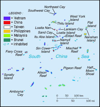
This is a list of airports in the Spratly Islands in the South China Sea.

Airports

LocationOccupied byNameCodeBuiltLengthNotes
Taiping Island Flag of the Republic of China.svg  Republic of China Taiping Island Airport RCSP20071,200 m (est.)Military use only. No refueling facilities. [1]
Swallow Reef (Layang-Layang)Flag of Malaysia.svg  Malaysia Layang-Layang Airport LAC19951,367 mDual-use concrete airport.
Fiery Cross Reef Flag of the People's Republic of China.svg  People's Republic of China Yongshu Airport AG 455320163,300 m (est.)Dual-use concrete airport.
Subi Reef Flag of the People's Republic of China.svg  People's Republic of China Zhubi Airport 20163,000 m (est.)Dual-use concrete airport.
Mischief Reef Flag of the People's Republic of China.svg  People's Republic of China Meiji Airport 20162,700 m (est.)Dual-use concrete airport.
Thitu Island (Pag-asa)Flag of the Philippines.svg  Philippines Rancudo Airfield RPPN19781,300 m (est.)Dual-use concrete airport. [2]
Spratly Island (Trường Sa)Flag of Vietnam.svg  Vietnam Trường Sa Airport 1976–771,200 m (est.) [3] Military use only. Extended from 600 m to 1,200 m in 2016. [3]

Location

Related Research Articles

<span class="mw-page-title-main">Spratly Islands</span> Disputed archipelago in the South China Sea

The Spratly Islands are a disputed archipelago in the South China Sea. Composed of islands, islets, cays, and more than 100 reefs, sometimes grouped in submerged old atolls, the archipelago lies off the coasts of the Philippines, Malaysia, and southern Vietnam. Named after the 19th-century British whaling captain Richard Spratly who sighted Spratly Island in 1843, the islands contain less than 2 km2 of naturally occurring land area, which is spread over an area of more than 425,000 km2 (164,000 sq mi).

<span class="mw-page-title-main">South China Sea</span> Marginal sea of the Western Pacific Ocean

The South China Sea is a marginal sea of the Western Pacific Ocean. It is bounded in the north by South China, in the west by the Indochinese Peninsula, in the east by the islands of Taiwan and northwestern Philippines, and in the south by the Indonesian islands of Borneo, eastern Sumatra and the Bangka Belitung Islands, encompassing an area of around 3,500,000 km2 (1,400,000 sq mi). It communicates with the East China Sea via the Taiwan Strait, the Philippine Sea via the Luzon Strait, the Sulu Sea via the straits around Palawan, and the Java Sea via the Karimata and Bangka Straits. The Gulf of Thailand and the Gulf of Tonkin are part of the South China Sea.

<span class="mw-page-title-main">South China Sea Islands</span> Islands in the South China Sea

The South China Sea Islands consist of over 250 islands, atolls, cays, shoals, reefs and seamounts in the South China Sea. The islands are mostly low and small, and have few inhabitants. The islands and surrounding seas are subject to overlapping territorial claims by the countries bordering the South China Sea.

<span class="mw-page-title-main">Taiping Island</span> Disputed island in the South China Sea

Taiping Island, also known as Itu Aba, and various other names, is the largest of the naturally occurring Spratly Islands in the South China Sea. The island is elliptical in shape being 1.4 kilometres (0.87 mi) in length and 0.4 kilometres (0.25 mi) in width, with an area of 46 hectares. It is located on the northern edge of the Tizard Bank. The runway of the Taiping Island Airport is easily the most prominent feature on the island, running its entire length.

<span class="mw-page-title-main">Kalayaan, Palawan</span> Municipality in Palawan, Philippines

Kalayaan, officially the Municipality of Kalayaan, is a 5th class municipality in the South China Sea under the jurisdiction of the province of Palawan, Philippines. According to the 2020 census, it has a population of 193 people making it the least populated town in the Philippines.

<span class="mw-page-title-main">Battle of the Paracel Islands</span> Naval battle

The Battle of the Paracel Islands was a military engagement between the naval forces of China and South Vietnam in the Paracel Islands on January 19, 1974. The battle was an attempt by the South Vietnamese navy to expel the Chinese navy from the vicinity. The confrontation took place towards the end of the Vietnam War.

<span class="mw-page-title-main">Thitu Island</span> Disputed island in the Spratly islands

Thitu Island, also known as Pag-asa Island, having an area of 37.2 hectares, is the second largest of the naturally occurring Spratly Islands and the largest of the Philippine-administered islands. It lies about 500 kilometers (310 mi) west of Puerto Princesa. Its neighbors are the North Danger Reef to the north, Subi Reef to the west, and the Loaita and Tizard Banks to the south.

<span class="mw-page-title-main">Swallow Reef</span>

Swallow Reef, also known as Malay: Pulau Layang-Layang; Vietnamese: Đá Hoa Lau; Mandarin Chinese: 燕子島; pinyin: Yànzi Dǎo; Celerio Reef, is an oceanic atoll of the Spratly Islands administered by Malaysia, which is situated approximately 300 kilometres (190 mi) northwest of Kota Kinabalu, Sabah. The atoll is about 7 km long and 2 km wide with a central lagoon. The part of the atoll above sea level is a reef on the south-east rim which had an original land area of approximately 6.2 hectares, but with reclaimed land now covers 35 hectares, measuring over 1.5 kilometres (0.93 mi) long and 200 m (656 ft) wide.

<span class="mw-page-title-main">Sansha</span> Prefecture-level city in Hainan, Peoples Republic of China

Sansha City is a prefecture-level city under the Hainan province of the People's Republic of China (PRC), and is the southernmost and least populated prefecture in China, with the smallest land area but the largest maritime territory. The city's seat is located on Yongxing Island in the South China Sea, and administers several island groups, atolls, seamounts and a number of other ungrouped maritime features within the nine-dash line, although the PRC's de facto control over the area varies. The name "Sansha", literally meaning "three sands", refers to the three archipelago districts of Xisha, Zhongsha and Nansha.

<span class="mw-page-title-main">Philippines and the Spratly Islands</span> Philippine policies, actions and history in the Spratly Islands

Philippines and the Spratly Islands – this article discusses the policies, activities and history of the Republic of the Philippines in the Spratly Islands from the Philippine perspective. Non-Philippine viewpoints regarding Philippine occupation of several islands are currently not included in this article.

<span class="mw-page-title-main">Spratly Island</span> One of the Spratly Islands in the South China Sea

Spratly Island, also known as Storm Island, is the fourth largest of the naturally occurring Spratly Islands in the South China Sea with an area of 15 hectares, and the largest of the Vietnamese-administered Spratly islands.

<span class="mw-page-title-main">Subi Reef</span> Disputed reef in the Spratly Islands

Subi Reef, also known as Zamora Reef ; Zhubi Reef ; Vietnamese: đá Xu Bi, is an atoll in the Spratly Islands of the South China Sea located 26 km (16 mi) southwest of Philippines' Pag-asa island Thitu Island under the municipality of the Kalayaan Island Group, Palawan province as claimed by Philippines. It is occupied by China (PRC), and claimed by Taiwan (ROC) and Vietnam. According to the claims of the PRC, it currently falls under the de facto jurisdiction of Nansha islands, Sansha city, Hainan province, China. But under the clauses of the UNCLOS, which the PRC is also a signatory, the international law only the Philippines has the maritime rights to exploit its resources or build structures, as it is within the continental shelf of the coastal country.

<span class="mw-page-title-main">Mischief Reef</span> Island in the South China Sea

Mischief Reef, also known as Panganiban Reef, is a low tide elevation (LTE) reef/atoll surrounding a large lagoon in the SE of Dangerous Ground in the east of the Spratly Islands in the South China Sea. It is located 250 kilometres (130 nmi) west of Palawan Island of the Philippines. Administratively, it belonged to the Kalayaan Islands municipality of the province of Palawan. It is also under the de facto jurisdiction of Nansha islands, Sansha City, Hainan province, China. Activities by the People's Republic of China (PRC) in the mid-2010s have created a large artificial island on the atoll including an approximately 2,700-metre (8,900 ft) runway and associated airfield.

<span class="mw-page-title-main">Spratly Islands dispute</span> Territorial dispute between China and Southeast Asian countries.

The Spratly Islands dispute is an ongoing territorial dispute between China, the Philippines, Taiwan, Malaysia, Vietnam, and Brunei, concerning "ownership" of the Spratly Islands, a group of islands and associated "maritime features" located in the South China Sea. The dispute is characterized by diplomatic stalemate and the employment of military pressure techniques in the advancement of national territorial claims. All except Brunei occupy some of the maritime features.

<span class="mw-page-title-main">Taiping Island Airport</span> Airport in Taiping Island

Taiping Island Airport is an airport on Taiping Island, Cijin District, Kaohsiung, Taiwan. It is located in the Spratly Islands of the South China Sea. The island has been stationed by the Republic of China (Taiwan) with military personnel since 1956.

<span class="mw-page-title-main">Sansha Yongxing Airport</span> Airport in Yongxing Island

Sansha Yongxing Airport, also known as Yongxing Island Airport, Woody Island Airport, is a civilian-military dual-use airport located on Yongxing (Woody) Island, the largest of the disputed Paracel Islands in the South China Sea. Yongxing/Woody Island is occupied and administered by China (PRC) as the seat of Sansha city of Hainan Province. The airport was expanded in 1990 to increase the combat range of Chinese warplanes. Further construction and reclamation of land commenced in 2012 to lengthen the airstrip. This work was completed in October 2014.

<span class="mw-page-title-main">Fiery Cross Reef</span> Airport in Fiery Cross Reef

Fiery Cross Reef, also known as "Northwest Investigator Reef", Mandarin Chinese: 永暑礁; pinyin: Yǒngshǔ Jiāo; Kagitingan Reef ; Vietnamese: Đá Chữ Thập, is a militarized reef occupied and controlled by China (PRC) as part of Sansha of Hainan Province and is also claimed by the Republic of China (ROC/Taiwan), the Philippines and Vietnam.

<i>Philippines v. China</i> 2016 international arbitration case

Philippines v. China, also known as the South China Sea Arbitration, was an arbitration case brought by the Republic of the Philippines against the People's Republic of China (PRC) under Annex VII of the United Nations Convention on the Law of the Sea concerning certain issues in the South China Sea, including the nine-dash line introduced by the mainland-based Republic of China since as early as 1947. A tribunal of arbitrators appointed the Permanent Court of Arbitration (PCA) as the registry for the proceedings.

Layang-Layang Airport is located on Swallow Reef in the Spratly Islands of the South China Sea. It is about 300 kilometres (190 mi) north of Kota Kinabalu, Sabah. The airport serves a Royal Malaysian Navy naval station and a 3-star diving resort as well as a marine research facility, MARSAL.

References

  1. The Taiping Island Airport was completed in December 2007, ("MND admits strategic value of Spratly airstrip." Taipei Times . 6 January 2006. p. 2 (MND is the ROC Ministry of National Defense)), and a C-130 Hercules transporter airplane first landed on the island on 21 January 2008.
  2. Bong Lozada (18 June 2014). "Air Force to repair Pagasa Island airstrip". Philippine Daily Inquirer . Retrieved 2016-12-26.
  3. 1 2 "Vietnam Responds". Center for Strategic and International Studies. 2016-12-01. Retrieved 2016-12-26.

Further reading