The Bockkarkopf is a mountain, 2,609 m high, and part of the main ridge of the Allgäu Alps. It is the ninth highest peak in the Allgäu Alps and is located between the Wilder Mann to the southwest and the Hochfrottspitze to the northeast. The busy Heilbronn Way runs over the pyramidal peak.

The Hochfrottspitze is a 2,649 metre high mountain, made of main dolomite, in the Allgäu Alps near Oberstdorf in Germany and the highest German mountain in the Allgäu Alps. The border with Austria runs along its ridge.
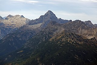
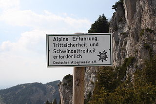
The Hochvogel is a 2,592-metre-high (8,504 ft) mountain in the Allgäu Alps. The national border between Germany and Austria runs over the summit. Although only the thirteenth highest summit in the Allgäu Alps, the Hochvogel dominates other parts of Allgäu Alps and the other ranges in the immediate neighbourhood. This is due to the fact that the majority of the higher peaks are concentrated in the central and western part of the Allgäu Alps. The Hochvogel stands on its own in the eastern part of the mountain group; the nearest neighbouring summits are 200 to 300 metres lower. Experienced climbers can ascend the summit on two marked routes.

The Krottenspitze (2,551m) is a mountain in the Allgäu Alps. It is one of the few rocky summits of the main ridge that is visible from Oberstdorf.

The Mädelegabel is a 2,645 metre high mountain, made of main dolomite, in the Allgäu Alps near Oberstdorf. It is one of the best-known and most-climbed high peaks in the German Alps, Within the Allgäu Alps it is the fourth-highest summit, with rock faces up to 400 metres high. Together with the Trettachspitze and the Hochfrottspitze it forms the famous triumvirate of peaks on the main crest of the Allgäu. Its name comes from Mähder - a mown mountain pasture in the vicinity - and gabel from the appearance of the triumvirate to the north which recalls a fork. Originally the Mädelegabel was the name for all three peaks of the triumvirate; only later were they distinguished from one another by name.

Mußkopf is a mountain in the Allgäu Alps which are located in Bavaria, Germany. It is a peak above a steep couloir, below the Rappensee Hut alpine hut. There is no marked trail to the peak.

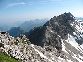
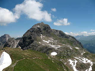
The Trettachspitze is a 2,595 metre high mountain in the Allgäu Alps in Germany. Due to its striking appearance it is one of the best-known mountains in the Allgäu Alps.

The Salober ist a 2,088 -high grass mountain in the Allgäu Alps. It lies northeast of the Laufbacher Eck.
The First Schafalpenkopf or Southwestern Schafalpenkopf is a 2,272-metre-high mountain in the Allgäu Alps. It is part of the Schafalpenköpfe and the Mindelheim Klettersteig.

The Großer Krottenkopf is the highest mountain in the Allgäu Alps of Austria. It is 2,656 m (AA) and is part of a side branch of the Hornbach chain, which branches off the main chain of the Allgäu Alps and runs for about 15 km eastwards.
The Steinschartenkopf is a rocky peak, 2,615 m, in the Hochlicht range in the Allgäu Alps. It is located between the Wilder Mann to the north and the Hohes Licht to the south and is the sixth highest summit in the Allgäu Alps. The popular Heilbronn Way runs over the summit.

The Marchspitze is a prominent summit, made of main dolomite, in the Hornbach chain of the Allgäu Alps. It is located 1.5 kilometres east of the much better known Großer Krottenkopf and is entirely on Austrian soil.

The Bretterspitze is a 2,608-metre-high summit in the Austrian state of Tyrol. It is part of the Hornbach chain in the Allgäu Alps. Its neighbouring peaks in the Hornbach chain are the Gliegerkarspitze to the west and the Urbeleskarspitze to the northeast. The broad summit block of the Bretterspitze is made of main dolomite.

The Großer Widderstein is a mountain, 2,533 m (AA), in the west Austrian state of Vorarlberg. Topographically it belongs to the Allgäu Alps. It is the highest peak in the subgroup of the Southeastern Walsertal Mountains.

The Kellenspitze, often also called the Kellespitze or Köllenspitze, at 2,238 m (AA) is the highest peak in the Tannheim Mountains. It lies in the Austrian state of Tyrol. Originally the mountain was known locally as the Metzenarsch, but when in 1854 Marie Frederica of Prussia visited the hunting lodge on the Tegelberg and was having the surrounding peaks pointed out, they called it after In der Kelle, the name of a strip of land at the foot of the mountain, because its original name referred to a Matz, in other words a prostitute, and seemed inappropriate.

The Gimpel is a peak in the Tannheim Mountains, a sub-range of the Allgäu Alps. It is 2,173 m high. The name is derived from the Gimpelalpe alp in der "hollow" (Mulde). The Gimpel is made of Wetterstein limestone.

The Noppenspitze is a rocky summit, 2,594 metres high, in the central part of the Hornbach chain of the Allgäu Alps.

The Kreuzkarspitze is a 2,587-metre-high Austrian mountain in the Hornbach chain of the Allgäu Alps.