Bathinda is a city and municipal corporation in Punjab, India. The city is the administrative headquarters of Bathinda District. It is located in northwestern India in the Malwa Region, 227 km (141 mi) west of the capital city of Chandigarh and is the fifth largest city of Punjab.
Muzaffargarh District is a district of the Punjab province of Pakistan. Its capital is Muzaffargarh city. It lies on the bank of the Chenab River.

Mansa is a city of Punjab. It is the administrative headquarters of Mansa district and is situated on the Bathinda-Jind-Delhi railway line and also on the Barnala-Sardulgarh-Sirsa state highway.

Mansa district is a district in the state of Punjab, India. The district headquarters is Mansa city. Mansa district was formed on 13 April 1992 from the erst while district of Bathinda. The district has three tehsils: Mansa, Budhlada and Sardulgarh; and five development blocks: Mansa, Budhlada, Sardulgarh, Bhikhi and Jhunir.

Sri Ganganagar is the northernmost city of the Indian state of Rajasthan, near the international border of India and Pakistan. It is the administrative headquarters of Sri Ganganagar district. It is named after Maharaja Shri Ganga Singh Bahadur, Maharaja of Bikaner. The city is also known as the "Food Basket of Rajasthan".

Firozpur district, also known as Ferozepur district, is one of the twenty-three districts in the state of Punjab, India. Firozpur district comprises an area of 2,190 km2 (850 sq mi).

Hanumangarh district is a district in the state of Rajasthan in India. The city of Hanumangarh is the district headquarters and its largest city.

Majha is a region located in the central parts of the historical Punjab region split between India and Pakistan. It extends north from the right banks of the river Beas, and reaches as far north as the river Jhelum. People of the Majha region are given the demonym "Mājhī" or "Majhail". Most inhabitants of the region speak the Majhi dialect, which is the basis of the standard register of the Punjabi language. The most populous city in the area is Lahore on the Pakistani side, and Amritsar on the Indian side of the border.
Malwa is a geographical region in the south of Punjab state in India. It is located between south of the Sutlej river, north of the Ghaggar river, east of Pakistan, and west of the Sivalik Hills.
Kot Kapura is a historic city in Faridkot district, some 50 km from Bathinda, 40 km from Moga and 30 km from Muktsar in the state of Punjab, India. It is the largest city in the Faridkot District and has a large cotton market. It takes around 15 minutes by bus from Faridkot, 4 hours by road from Chandigarh and 2 hours from Ludhiana, and 8 hours from New Delhi by train to reach the city. It is a central city on route to Ganganagar, Ludhiana, Bathinda, Firozpur, etc. Kot Kapura takes its name from its founder, Nawab Kapur Singh, and the word 'Kot', meaning a small fort – literally the 'Fort of Kapura'. The city is known for its "Dhodha Sweet" and "Atta Chicken" both of which are exported outside India.

Fazilka, also known as Bangla, is a city and a municipal council in Fazilka district of Punjab, India. In 2011, it was made the headquarter of the newly created Fazilka district. The Trans-Afghanistan Pipeline (TAPI) project originating in Turkmenistan will have its last station in Fazilka.
Giddarbaha, is a town and a municipal council in Muktsar district, in the Indian state of Punjab. It is 19 kilometres (12 mi) from the city of Malout, 30 kilometres (19 mi) from the city of Bathinda and 40 kilometres (25 mi) from the city of Muktsar. It lies on NH-7, which connects Fazilka (Punjab) to Mana (Uttarakhand) in India.
Dhudike is a village in Moga Tehsil in Moga district of Punjab state, India. It is located 17 km east from city of Moga, the district headquarter. Freedom fighters like Baba Ishar Singh, Baba Pala Singh Jathedar, Baba Pakhar Singh are a few of the Gadaree from Dhudike who participated in the Gadar Movement during the struggle for independence. Dhudike was the birthplace of the famous Lala Lajpat Rai.

Punjab is a state in northern India. Forming part of the larger Punjab region of the Indian subcontinent, the state is bordered by the Indian states of Himachal Pradesh to the north and northeast, Haryana to the south and southeast, and Rajasthan to the southwest; by the Indian union territories of Chandigarh to the east and Jammu and Kashmir to the north. It shares an international border with Punjab, a province of Pakistan to the west. The state covers an area of 50,362 square kilometres, which is 1.53% of India's total geographical area, making it the 19th-largest Indian state by area out of 28 Indian states. With over 27 million inhabitants, Punjab is the 16th-largest Indian state by population, comprising 23 districts. Punjabi, written in the Gurmukhi script, is the most widely spoken and the official language of the state. The main ethnic groups are the Punjabis, with Sikhs (57.7%) and Hindus (38.5%) as the dominant religious groups. The state capital is Chandigarh, a union territory and also the capital of the neighbouring state of Haryana. Three tributaries of the Indus, viz., Sutlej, Beas, and Ravi, flow through Punjab.

Malwai is a Punjabi dialect spoken in the Malwa region of Punjab.
Sri Gurusar Modia is a village in the Indian state of Rajasthan situated near borders of Rajasthan, Haryana and Punjab states and the international border of India and Pakistan. This village is located in the tehsil Suratgarh of district Sriganganagar. Suratgarh, once known as Sodhal was believed to be surrounded by the confluence of Saraswati and Drishyati rivers but now the land is a deserted one lying amidst the expanse of The great Indian Thar desert. Suratgarh is famous for its agriculture, air force and army base stations, largest thermal power plant of Rajasthan and largest radio station of Rajasthan called as "Cotton City Channel". Sri Gurusar Modia came into limelight when a controversial self-proclaimed saint and spiritual leader Gurmeet Ram Rahim Singh was believed to be incarnated there and crowned to the throne of Dera Sacha Sauda at Sirsa in 1991. With setting up of Shah Satnam Schools for both boys and girls, super speciality hospitals etc. this village became nationwide popular
Raipur, located in the Sardulgarh tehsil of Mansa district in Punjab, India, is an old and noted village of the area. The famous Babbar martyr Bhai Gurmel Singh from the village was martyred during an operation in Maujia on 8 September 1991.

Sikhwala is a village in the Malout Tehsil of Sri Muktsar Sahib district in Punjab, India.
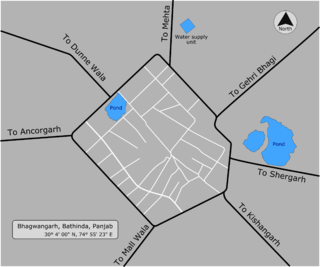
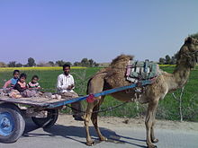
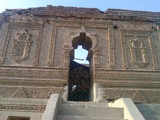
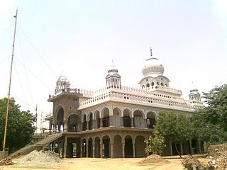
Bhagwangarh, also known as Bhukhianwali is a village of Talwandi Sabo tehsil of Bathinda district of Indian Panjab.