Albareto is a comune (municipality) in the Province of Parma in the Italian region Emilia-Romagna, located about 130 kilometres (81 mi) west of Bologna and about 60 kilometres (37 mi) southwest of Parma.

Calestano is a comune (municipality) in the Province of Parma in the Italian region Emilia-Romagna, located about 100 kilometres (62 mi) west of Bologna and about 30 kilometres (19 mi) southwest of Parma.
Corniglio is a comune (municipality) in the Province of Parma in the Italian region Emilia-Romagna, located about 100 kilometres (62 mi) west of Bologna and about 40 kilometres (25 mi) southwest of Parma.

Fontevivo is a comune (municipality) in the Province of Parma in the Italian region Emilia-Romagna, located about 100 kilometres (62 mi) northwest of Bologna and about 14 kilometres (9 mi) northwest of Parma. As of 31 December 2004, it had a population of 5,337 and an area of 25.9 square kilometres (10.0 sq mi).

Langhirano is a comune (municipality) in the Province of Parma in the Italian region Emilia-Romagna, located about 90 kilometres (56 mi) west of Bologna and about 20 kilometres (12 mi) south of Parma.
Lesignano de' Bagni is a comune (municipality) in the Province of Parma in the Italian region Emilia-Romagna, located about 90 kilometres (56 mi) west of Bologna and about 15 kilometres (9 mi) south of Parma.

Medesano is a comune (municipality) in the Province of Parma in the Italian region Emilia-Romagna, located about 100 kilometres (62 mi) northwest of Bologna and about 15 kilometres (9 mi) southwest of Parma. As of 31 May 2007, it had a population of 10,221 and an area of 88.8 square kilometres (34.3 sq mi).
Montechiarugolo is a comune (municipality) in the Province of Parma in the Italian region Emilia-Romagna, located about 80 kilometres (50 mi) northwest of Bologna and about 13 kilometres (8 mi) southeast of Parma.
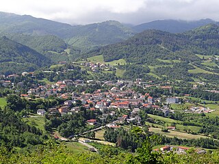
Palanzano is a comune (municipality) in the Province of Parma in the Italian region Emilia-Romagna, located about 90 kilometres (56 mi) west of Bologna and about 40 kilometres (25 mi) south of Parma. Palanzano borders the following municipalities: Corniglio, Monchio delle Corti, Neviano degli Arduini, Tizzano Val Parma, Ventasso, Vetto.

Pellegrino Parmense is a comune (municipality) in the Province of Parma in the Italian region Emilia-Romagna, located about 120 kilometres (75 mi) west of Bologna and about 35 kilometres (22 mi) west of Parma, in the northern part of the Valle del Ceno.

Sala Baganza is a comune (municipality) in the Province of Parma in the Italian region Emilia-Romagna, located about 90 kilometres (56 mi) northwest of Bologna and about 12 kilometres (7 mi) southwest of Parma.
San Secondo Parmense is a comune (municipality) in the Province of Parma in the Italian region Emilia-Romagna, located about 200 kilometres (120 mi) northwest of Bologna and about 15 kilometres (9 mi) northwest of Parma.

Solignano is a comune (municipality) in the Province of Parma in the Italian region Emilia-Romagna, located about 110 kilometres (68 mi) west of Bologna and about 35 kilometres (22 mi) southwest of Parma.
Sorbolo is a comune (municipality) in the Province of Parma in the Italian region Emilia-Romagna, located about 80 kilometres (50 mi) northwest of Bologna and about 11 kilometres (7 mi) northeast of Parma.

Tizzano Val Parma is a comune (municipality) in the Province of Parma in the Italian region Emilia-Romagna, located about 90 kilometres (56 mi) west of Bologna and about 35 kilometres (22 mi) southwest of Parma.
Tornolo is a comune (municipality) in the Province of Parma in the Italian region Emilia-Romagna, located about 140 kilometres (87 mi) west of Bologna and about 70 kilometres (43 mi) southwest of Parma.
Traversetolo is a comune (municipality) in the Province of Parma in the Italian region Emilia-Romagna, located about 80 kilometres (50 mi) west of Bologna and about 20 kilometres (12 mi) south of Parma.

Gattatico is a comune (municipality) in the Province of Reggio Emilia in the Italian region Emilia-Romagna, located about 80 kilometres (50 mi) northwest of Bologna and about 15 kilometres (9 mi) northwest of Reggio Emilia.

Varano de' Melegari is a comune (municipality) in the Province of Parma in the Italian region Emilia-Romagna, located about 110 kilometres (68 mi) west of Bologna and about 30 kilometres (19 mi) southwest of Parma.

Varsi is a comune (municipality) in the Province of Parma in the Italian region Emilia-Romagna, located about 120 kilometres (75 mi) west of Bologna and about 40 kilometres (25 mi) southwest of Parma.