Albareto is a comune (municipality) in the Province of Parma in the Italian region Emilia-Romagna, located about 130 kilometres (81 mi) west of Bologna and about 60 kilometres (37 mi) southwest of Parma.

Calestano is a comune (municipality) in the Province of Parma in the Italian region Emilia-Romagna, located about 100 kilometres (62 mi) west of Bologna and about 30 kilometres (19 mi) southwest of Parma.
Corniglio is a comune (municipality) in the Province of Parma in the Italian region Emilia-Romagna, located about 100 kilometres (62 mi) west of Bologna and about 40 kilometres (25 mi) southwest of Parma.

Fontevivo is a comune (municipality) in the Province of Parma in the Italian region Emilia-Romagna, located about 100 kilometres (62 mi) northwest of Bologna and about 14 kilometres (9 mi) northwest of Parma. As of 31 December 2004, it had a population of 5,337 and an area of 25.9 square kilometres (10.0 sq mi).

Langhirano is a comune (municipality) in the Province of Parma in the Italian region Emilia-Romagna, located about 90 kilometres (56 mi) west of Bologna and about 20 kilometres (12 mi) south of Parma.
Lesignano de' Bagni is a comune (municipality) in the Province of Parma in the Italian region Emilia-Romagna, located about 90 kilometres (56 mi) west of Bologna and about 15 kilometres (9 mi) south of Parma.

Monchio delle Corti is a comune (municipality) in the Province of Parma in the Italian region Emilia-Romagna, located about 100 kilometres (62 mi) west of Bologna and about 45 kilometres (28 mi) southwest of Parma, including part of the Appennino Parmense. The Monte Sillara, at 1,861 metres (6,106 ft), is the highest peak in the province.
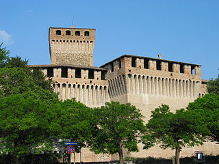
Montechiarugolo is a comune (municipality) in the Province of Parma in the Italian region Emilia-Romagna, located about 80 kilometres (50 mi) northwest of Bologna and about 13 kilometres (8 mi) southeast of Parma.

Noceto is a comune (municipality) in the province of Parma in the Italian region Emilia-Romagna, located about 100 kilometres (62 mi) northwest of Bologna and about 12 kilometres (7 mi) west of Parma.
Palanzano is a comune (municipality) in the Province of Parma in the Italian region Emilia-Romagna, located about 90 kilometres (56 mi) west of Bologna and about 40 kilometres (25 mi) south of Parma. Palanzano borders the following municipalities: Corniglio, Monchio delle Corti, Neviano degli Arduini, Tizzano Val Parma, Ventasso, Vetto.

Pellegrino Parmense is a comune (municipality) in the Province of Parma in the Italian region Emilia-Romagna, located about 120 kilometres (75 mi) west of Bologna and about 35 kilometres (22 mi) west of Parma, in the northern part of the Valle del Ceno.
San Secondo Parmense is a comune (municipality) in the Province of Parma in the Italian region Emilia-Romagna, located about 200 kilometres (120 mi) northwest of Bologna and about 15 kilometres (9 mi) northwest of Parma.

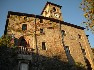
Solignano is a comune (municipality) in the Province of Parma in the Italian region Emilia-Romagna, located about 110 kilometres (68 mi) west of Bologna and about 35 kilometres (22 mi) southwest of Parma.
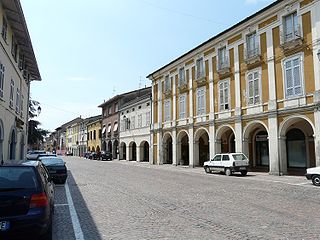
Sorbolo is a comune (municipality) in the Province of Parma in the Italian region Emilia-Romagna, located about 80 kilometres (50 mi) northwest of Bologna and about 11 kilometres (7 mi) northeast of Parma.

Tizzano Val Parma is a comune (municipality) in the Province of Parma in the Italian region Emilia-Romagna, located about 90 kilometres (56 mi) west of Bologna and about 35 kilometres (22 mi) southwest of Parma.
Tornolo is a comune (municipality) in the Province of Parma in the Italian region Emilia-Romagna, located about 140 kilometres (87 mi) west of Bologna and about 70 kilometres (43 mi) southwest of Parma.

Torrile is a comune (municipality) in the Province of Parma in the Italian region Emilia-Romagna, located about 90 kilometres (56 mi) northwest of Bologna and about 13 kilometres (8 mi) north of Parma.
Traversetolo is a comune (municipality) in the Province of Parma in the Italian region Emilia-Romagna, located about 80 kilometres (50 mi) west of Bologna and about 20 kilometres (12 mi) south of Parma.
Valmozzola is a comune (municipality) in the Province of Parma in the Italian region Emilia-Romagna, located about 120 kilometres (75 mi) west of Bologna and about 45 kilometres (28 mi) southwest of Parma.

Varano de' Melegari is a comune (municipality) in the Province of Parma in the Italian region Emilia-Romagna, located about 110 kilometres (68 mi) west of Bologna and about 30 kilometres (19 mi) southwest of Parma.