Neviano degli Arduini

Last updated
Neviano degli Arduini
Comune
Comune di Neviano degli Arduini

PieveDiSassoAbside.jpg

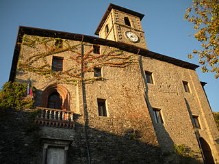
Apse of the Pieve di Sasso.
Italy provincial location map 2015.svg
Red pog.svg
Neviano degli Arduini
Location of Neviano degli Arduini in Italy
Coordinates: 44°35′N10°19′E / 44.583°N 10.317°E / 44.583; 10.317 Coordinates: 44°35′N10°19′E / 44.583°N 10.317°E / 44.583; 10.317
Country Italy
Region Emilia-Romagna
Province Parma (PR)
Frazioni Antreola, Ariolla, Begozzo, Bertogallo, Campo del Fico, Campora, Case Bedi, Case Bodini, Case Bosi, Case Campanari, Case Canale, Case della Fossa, Case Fantini, Case Mazza, Case Paini, Case Penuzzi, Case Ruffaldi, Castelmozzano, Cedogno, Ceretolo, Cerreto, Corchio, Corticone, Costola, Formiano, La Bricola, La Costa, La Villa, Le Mole, Lodrignano, Lugaro, Lupazzano, Magrignano, Mercato, Misone, Monchio, Monte, Montetenero, Montroni, Mozzano, Mussatico, Neda, Orzale, Paderna, Pezzalunga, Piazza, Prada, Provazzano, Quinzano, Quinzo, Rivareto, Romazza, Sasso, Scorcoro, Sella di Lodrignano, Signano, Tissore, Urzano, Vezzano, Vico, Vignetta
Government
  Mayor Giordano Bricoli
Area
  Total 105.9 km2 (40.9 sq mi)
Population (31 May 2007) [1]
  Total 3,724
  Density 35/km2 (91/sq mi)
Time zone CET (UTC+1)
  Summer (DST) CEST (UTC+2)
Postal code43024
Dialing code 0521
Website Official website

Neviano degli Arduini (Parmigiano: Nevian di Arduèn) is a comune (municipality) in the Province of Parma in the Italian region Emilia-Romagna, located about 80 kilometres (50 mi) west of Bologna and about 25 kilometres (16 mi) south of Parma.

The Parmigiano dialect, sometimes the Parmesan dialect, is a dialect of the Emilian language spoken in the Province of Parma, the western-central portion of the Emilia-Romagna administrative region.

<i>Comune</i> third-level administrative divisions of the Italian Republic

The comune is a basic administrative division in Italy, roughly equivalent to a township or municipality.

Province of Parma Province of Italy

The Province of Parma is a province in the Emilia-Romagna region of Italy. Its largest town and capital is the city of Parma.

Contents

In the communal territory is the Romanesque Pieve di Sasso, a national monument, dating from the 11th century. Its reconstruction around 1080 is traditionally attributed to Matilda of Tuscany. It is a church with a nave and two aisles, built in rough stone. Notable is the façade, parted by thin pilasters and a medieval portal. It houses a sculpted baptismal font with octagonal plan, and figures of the Evangelists.

Romanesque architecture architectural style of Medieval Europe

Romanesque architecture is an architectural style of medieval Europe characterized by semi-circular arches. There is no consensus for the beginning date of the Romanesque style, with proposals ranging from the 6th to the 11th century, this later date being the most commonly held. In the 12th century it developed into the Gothic style, marked by pointed arches. Examples of Romanesque architecture can be found across the continent, making it the first pan-European architectural style since Imperial Roman architecture. The Romanesque style in England is traditionally referred to as Norman architecture.

Pieve

In the Middle Ages, a pieve was a rural church with a baptistery, upon which other churches without baptisteries depended.

Matilda of Tuscany Italian feudal margrave of Tuscany, ruler in northern Italy and the chief Italian supporter of Pope Gregory VII during the Investiture Controversy

Matilda of Tuscany was a powerful feudal Margravine of Tuscany, ruler in northern Italy and the chief Italian supporter of Pope Gregory VII during the Investiture Controversy; in addition, she was one of the few medieval women to be remembered for her military accomplishments, thanks to which she was able to dominate all the territories north of the Papal States.

Twin towns

Related Research Articles

Albareto Comune in Emilia-Romagna, Italy

Albareto is a comune (municipality) in the Province of Parma in the Italian region Emilia-Romagna, located about 130 kilometres (81 mi) west of Bologna and about 60 kilometres (37 mi) southwest of Parma.

Colorno Comune in Emilia-Romagna, Italy

Colorno is a comune (municipality) in the Province of Parma in the Italian region Emilia-Romagna, located about 90 kilometres (56 mi) northwest of Bologna and about 15 kilometres (9 mi) north of Parma.

Corniglio Comune in Emilia-Romagna, Italy

Corniglio is a comune (municipality) in the Province of Parma in the Italian region Emilia-Romagna, located about 100 kilometres (62 mi) west of Bologna and about 40 kilometres (25 mi) southwest of Parma.

Fontevivo Comune in Emilia-Romagna, Italy

Fontevivo is a comune (municipality) in the Province of Parma in the Italian region Emilia-Romagna, located about 100 kilometres (62 mi) northwest of Bologna and about 14 kilometres (9 mi) northwest of Parma. As of 31 December 2004, it had a population of 5,337 and an area of 25.9 square kilometres (10.0 sq mi).

Fornovo di Taro Comune in Emilia-Romagna, Italy

Fornovo di Taro is a comune (municipality) in the province of Parma, in the Italian region Emilia-Romagna, located about 100 kilometres (62 mi) west of Bologna and about 25 kilometres (16 mi) southwest of Parma. The town lies on the east bank of the Taro River.

Langhirano Comune in Emilia-Romagna, Italy

Langhirano is a comune (municipality) in the Province of Parma in the Italian region Emilia-Romagna, located about 90 kilometres (56 mi) west of Bologna and about 20 kilometres (12 mi) south of Parma.

Lesignano de Bagni Comune in Emilia-Romagna, Italy

Lesignano de' Bagni is a comune (municipality) in the Province of Parma in the Italian region Emilia-Romagna, located about 90 kilometres (56 mi) west of Bologna and about 15 kilometres (9 mi) south of Parma.

Medesano Comune in Emilia-Romagna, Italy

Medesano is a comune (municipality) in the Province of Parma in the Italian region Emilia-Romagna, located about 100 kilometres (62 mi) northwest of Bologna and about 15 kilometres (9 mi) southwest of Parma. As of 31 May 2007, it had a population of 10,221 and an area of 88.8 square kilometres (34.3 sq mi).

Monchio delle Corti Comune in Emilia-Romagna, Italy

Monchio delle Corti is a comune (municipality) in the Province of Parma in the Italian region Emilia-Romagna, located about 100 kilometres (62 mi) west of Bologna and about 45 kilometres (28 mi) southwest of Parma, including part of the Appennino Parmense. The Monte Sillara, at 1,861 metres (6,106 ft), is the highest peak in the province.

Montechiarugolo Comune in Emilia-Romagna, Italy

Montechiarugolo is a comune (municipality) in the Province of Parma in the Italian region Emilia-Romagna, located about 80 kilometres (50 mi) northwest of Bologna and about 13 kilometres (8 mi) southeast of Parma.

Palanzano Comune in Emilia-Romagna, Italy

Palanzano is a comune (municipality) in the Province of Parma in the Italian region Emilia-Romagna, located about 90 kilometres (56 mi) west of Bologna and about 40 kilometres (25 mi) south of Parma. Palanzano borders the following municipalities: Corniglio, Monchio delle Corti, Neviano degli Arduini, Tizzano Val Parma, Ventasso, Vetto.

Pellegrino Parmense Comune in Emilia-Romagna, Italy

Pellegrino Parmense is a comune (municipality) in the Province of Parma in the Italian region Emilia-Romagna, located about 120 kilometres (75 mi) west of Bologna and about 35 kilometres (22 mi) west of Parma, in the northern part of the Valle del Ceno.

Sala Baganza Comune in Emilia-Romagna, Italy

Sala Baganza is a comune (municipality) in the Province of Parma in the Italian region Emilia-Romagna, located about 90 kilometres (56 mi) northwest of Bologna and about 12 kilometres (7 mi) southwest of Parma.

San Secondo Parmense Comune in Emilia-Romagna, Italy

San Secondo Parmense is a comune (municipality) in the Province of Parma in the Italian region Emilia-Romagna, located about 200 kilometres (120 mi) northwest of Bologna and about 15 kilometres (9 mi) northwest of Parma.

Solignano Comune in Emilia-Romagna, Italy

Solignano is a comune (municipality) in the Province of Parma in the Italian region Emilia-Romagna, located about 110 kilometres (68 mi) west of Bologna and about 35 kilometres (22 mi) southwest of Parma.

Tizzano Val Parma Comune in Emilia-Romagna, Italy

Tizzano Val Parma is a comune (municipality) in the Province of Parma in the Italian region Emilia-Romagna, located about 90 kilometres (56 mi) west of Bologna and about 35 kilometres (22 mi) southwest of Parma.

Traversetolo Comune in Emilia-Romagna, Italy

Traversetolo is a comune (municipality) in the Province of Parma in the Italian region Emilia-Romagna, located about 80 kilometres (50 mi) west of Bologna and about 20 kilometres (12 mi) south of Parma.

Valmozzola Comune in Emilia-Romagna, Italy

Valmozzola is a comune (municipality) in the Province of Parma in the Italian region Emilia-Romagna, located about 120 kilometres (75 mi) west of Bologna and about 45 kilometres (28 mi) southwest of Parma.

Varano de Melegari Comune in Emilia-Romagna, Italy

Varano de' Melegari is a comune (municipality) in the Province of Parma in the Italian region Emilia-Romagna, located about 110 kilometres (68 mi) west of Bologna and about 30 kilometres (19 mi) southwest of Parma.

Varsi Comune in Emilia-Romagna, Italy

Varsi is a comune (municipality) in the Province of Parma in the Italian region Emilia-Romagna, located about 120 kilometres (75 mi) west of Bologna and about 40 kilometres (25 mi) southwest of Parma.

References

  1. All demographics and other statistics: Italian statistical institute Istat.