Vandenburg | |
|---|---|
| Coordinates: 29°25′38″N99°07′01″W / 29.42727900°N 99.11705900°W | |
| Country | United States |
| State | Texas |
| County | Medina |
Vandenburg, formerly Castroville, is a ghost town in Medina County, Texas, United States.
Vandenburg | |
|---|---|
| Coordinates: 29°25′38″N99°07′01″W / 29.42727900°N 99.11705900°W | |
| Country | United States |
| State | Texas |
| County | Medina |
Vandenburg, formerly Castroville, is a ghost town in Medina County, Texas, United States.
Situated near Verde and Lucky Creek, Vandenburg was the second settlement of Henri Castro; he named it Castroville, after himself. [1] In 1846, while establishing other settlements, August Ferdinand Louis Huth was appointed in charge in Castro's absence. Verde Creek ran dry, and settlers moved to establish New Fountain. The town was barren by 1989. [2] [3]

Val Verde County is a county located on the southern Edwards Plateau in the U.S. state of Texas. The 2020 population is 47,586. Its county seat is Del Rio. The Del Rio micropolitan statistical area includes all of Val Verde County.

Medina County is a county located in the U.S. state of Texas. As of the 2020 census, its population was 50,748. Its county seat is Hondo. The county is named for the Medina River. The extreme northern part of the county lies within the Edwards Plateau, which elevates into the Texas Hill Country. The Medina Dam, the fourth largest in the nation when completed in 1913, is listed on the National Register of Historic Places. The irrigation project, creating Medina Lake, was built by 1500 skilled workers who worked in shifts operating 24 hours a day to complete the dam in two years. Medina County is part of the San Antonio, TX Metropolitan Statistical Area.

Kinney County is a county located in the U.S. state of Texas. As of the 2020 census, its population was 3,129. Its county seat is Brackettville. The county was created in 1850 and later organized in 1874. It is named for Henry Lawrence Kinney, an early settler.

Kerr County is a county located on the Edwards Plateau in the U.S. state of Texas. As of the 2020 census, its population was 52,598. Its county seat is Kerrville. The county was named by Joshua D. Brown for his fellow Kentucky native, James Kerr, a congressman of the Republic of Texas. The Kerrville, TX Micropolitan Statistical Area includes all of Kerr County.

Crockett County is a county located on the Edwards Plateau in the U.S. state of Texas. As of the 2020 census, its population was 3,098. The county seat is Ozona. The county was founded in 1875 and later organized in 1891. It is named in honor of Davy Crockett, the legendary frontiersman who died at the Battle of the Alamo.

Calhoun County is a county located in the U.S. state of Texas. As of the 2020 census, the population was 20,106. Its county seat is Port Lavaca. The county is named for John Caldwell Calhoun, the seventh vice president of the United States. Calhoun County comprises the Port Lavaca, TX Micropolitan Statistical Area, which is also included in the Victoria-Port Lavaca, TX Combined Statistical Area.

Bandera County is a county in the U.S. state of Texas. It is located in the Hill Country and its county seat is Bandera. Bandera county was settled by German and Polish emigrants in the mid 1800s. Many residents are descendants of those same emigrants.

Castroville is an unincorporated town and census-designated place (CDP) in Monterey County, California, United States. At the time of the 2020 census the population was 7,515, up from 6,481 in 2010. Castroville is known for its artichoke crop and for the annual Castroville Artichoke Festival, leading to its nickname as the "Artichoke Center of the World".

Castroville is a city in Medina County, Texas, United States. Its population was 2,954 at the 2020 census. Prior to 1893, Castroville was the first county seat of Medina County. Castroville was founded by Alsatian-Texans, who came to Texas during the German emigration period of the mid-1800s. Most Alsatians who came to Castroville spoke Alsatian. The Alsatian culture and language are still kept alive by the residents of Castroville.

Lavaca Bay is a northwestern extension of the Matagorda Bay system found mostly in Calhoun County, Texas, United States. The ports of Port Lavaca and Point Comfort have been established on the bay, and are the main areas of human habitation. Linnville was located on the bay until its abandonment after the Great Raid of 1840, and the major port of Indianola was found near the confluence with the main Matagorda Bay, until the town's final destruction following the massive hurricane of 1886. Smaller communities include Olivia, Alamo Beach and Magnolia Beach. Lavaca Bay is approximately 82 miles (130 km) northeast of Corpus Christi, about 121 miles (190 km) southwest of Houston, and 145 miles (230 km) southeast of San Antonio.

The Medina Dam is a hollow-masonry type dam built in 1911 and 1912 by the Medina Irrigation Company in what became Mico, Texas, USA. Medina Lake extends north of it in northeastern Medina County and southeastern Bandera County. The dam and irrigation project was designed and financed by Dr. Frederick Stark Pearson, an American engineer, with extensive British financial backing. The construction took over 1500 men two years to build while working 24 hours a day. They were mostly skilled Mexican workers with experience building other dams for Pearson. They received two dollars for a day's work, which were good wages for the time. Pearson's Medina Irrigation Company (MICO) built a camp to house the workers and their families; the company town was first called MICO after its acronym. The community is now known as Mico, Texas.

Henri Castro, was a French diplomat who was one of the most important empresarios of the Republic of Texas.

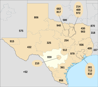
Area code 830 is the telephone area code in the North American Numbering Plan (NANP) for the Texas Hill Country and most of San Antonio's suburbs. It completely surrounds area codes 210 and 726, which serve most of San Antonio itself along with its innermost suburbs.
Dunlay is an unincorporated community in Medina County, Texas. It lies about six miles west of Castroville and eight miles east of Hondo on U.S. Highway 90.

The Landmark Inn State Historic Site is a historic inn in Castroville, Texas, United States. It serves the general public as both a state historic site and a bed & breakfast with eight overnight rooms.
The San Antonio–El Paso Road, also known as the Lower Emigrant Road or Military Road, was an economically important trade route between the Texas cities of San Antonio and El Paso between 1849 and 1882. Mail, freight, and passengers traveled by horse and wagon along this road across the Edwards Plateau and dangerous Trans-Pecos region of West Texas.
Mormon Mill is a vanished Mormon colony established in 1851 on Hamilton Creek in Burnet County, in the U.S. state of Texas. The site is located on Mormon Mills Road 5 miles (8.0 km) north of Marble Falls and 10 miles (16 km) south of Burnet. Mormon Mill has also been known as Mormon Mills, Mormon Mill Colony and Mormon Mill Historical Site. Designated a Recorded Texas Historic Landmark in 1936, Marker number 9733. The population moved to another county in 1853, and no buildings remain of the colony.

Quihi is a settlement in Medina County, in the U.S. state of Texas. Located 9 miles (14 km) north of Hondo, it sits at the intersection of Farm to Market Road 2676 and Quihi Creek. In 1936, Quihi received centennial marker Number 5537, a gray granite marker placed to commemorate the Texas Centennial.

New Fountain is a ghost town established in 1846. It is located 1.8 miles (2.9 km) west of Quihi and 5.6 miles (9.0 km) east northeast of Hondo in Medina County in the U.S. state of Texas. It was part of empresario Henri Castro's colonization of the Medina River valley in the Republic of Texas.

Castroville Historic District is a United States historic district in Castroville, Texas. It includes the oldest parts of the city of Castroville and contains twelve designated contributing properties, including a Texas State Historic Site and numerous Recorded Texas Historic Landmarks. The district was listed on the National Register of Historic Places in 1970.