
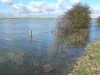
Breydon Water is a 514.4-hectare (1,271-acre) biological Site of Special Scientific Interest at Great Yarmouth, Norfolk. It is a Local Nature Reserve, a Ramsar site and a Special Protection Area. It is part of the Berney Marshes and Breydon Water nature reserve, which is managed by the Royal Society for the Protection of Birds (RSPB).
Nene Washes is a 1,522-hectare (3,760-acre) biological Site of Special Scientific Interest on the bank of the River Nene east of Peterborough in Cambridgeshire, England. It is also a Ramsar internationally important wetland site, a Special Area of Conservation, a Special Protection Area and a Nature Conservation Review site. An area of 280 hectares is managed by the Royal Society for the Protection of Birds. The total area of the Ramsar site is 1,517 hectares.

Colne Estuary is a 2915 hectare biological and geological Site of Special Scientific Interest near Brightlingsea in Essex. It is also a Nature Conservation Review site, a National Nature Reserve, a Ramsar wetland site of international importance, a Special Protection Area, a Special Area of Conservation, and a Geological Conservation Review site. Three areas in the site are managed by the Essex Wildlife Trust, Colne Point, Fingringhoe Wick and Howlands Marsh.

Ingrebourne Marshes are a 74.8 hectare biological Site of Special Scientific Interest in Hornchurch in the London Borough of Havering. Ingrebourne Valley Local Nature Reserve includes a small part of the SSSI west of the River Ingrebourne.
Dungeness, Romney Marsh and Rye Bay is a 10,172.9-hectare (25,138-acre) biological and geological Site of Special Scientific Interest which stretches from New Romney in Kent to Winchelsea in East Sussex. An area of 5,129.5 hectares is a Special Protection Area, an area of 3,141.1 hectares is a Special Area of Conservation, and an area of 6,377.6 hectares is a Ramsar Site, a wetland site designated of international importance under the Ramsar Convention. Part of the site is in the High Weald Area of Outstanding Natural Beauty, parts are Geological Conservation Review sites, part is a Local Nature Reserve, and part is a Royal Society for the Protection of Birds nature reserve, and part is a National Nature Reserve.

Trimley Marshes is a 77 hectare nature reserve west of Trimley St Mary, on the outskirts of Felixstowe in Suffolk. It is managed by the Suffolk Wildlife Trust. It is in the Suffolk Coast and Heaths Area of Outstanding Natural Beauty, the Orwell Estuary Site of Special Scientific Interest, the Stour and Orwell Estuaries Ramsar site internationally important wetland site and Special Protection Area under the European Union Directive on the Conservation of Wild Birds.

Cattawade Marshes is an 88.2-hectare (218-acre) biological Site of Special Scientific Interest between East Bergholt and Manningtree in Essex and Suffolk. It is managed by the Royal Society for the Protection of Birds. It is a Ramsar wetland of international importance, and part of the Stour and Orwell Special Protection Area, and the Dedham Vale Area of Outstanding Natural Beauty.

The Crouch and Roach Estuaries are a 1729 hectare biological Site of Special Scientific Interest (SSSI) at the mouth of the Crouch and Roach rivers in Essex. The Crouch part of the SSSI stretches from near Battlesbridge to Foulness Island, and the Roach from Rochford to the junction with the Crouch. Part of the site is in the Mid-Essex Coast Special Protection Area under the EC Directive on the Conservation of Wild Birds, and a Ramsar wetland site of international importance. It is also part of the Essex Estuaries Special Area of Conservation. An area of 65 hectares is managed by the Essex Wildlife Trust as the Lion Creek and Lower Raypits nature reserve and 8 hectares at Woodham Fen, both of which are managed by the Essex Wildlife Trust. A small area is also a geological SSSI, The Cliff, Burnham-on-Crouch.

Holehaven Creek is a 272.9-hectare (674-acre) biological Site of Special Scientific Interest (SSSI) between Canvey Island and Corringham in Essex.

Stour and Copperas Woods, Ramsey is a 77.1-hectare (191-acre) biological Site of Special Scientific Interest between Wrabness and Ramsey in Essex. It is two separate areas, Stour Wood, which is owned by the Woodland Trust and managed by the Royal Society for the Protection of Birds, and Copperas Wood, which is owned and managed by the Essex Wildlife Trust. It is in the Suffolk Coast and Heaths Area of Outstanding Natural Beauty.
Stour Estuary is a 2,523 hectare biological and geological Site of Special Scientific Interest which stretches from Manningtree to Harwich in Essex and Suffolk. It is also an internationally important wetland Ramsar site, a Special Protection Area and a Nature Conservation Review site. It is part of the Suffolk Coast and Heaths Area of Outstanding Natural Beauty, and there are Geological Conservation Review sites in Wrabness, Stutton, and Harwich Part of the site is managed by the Royal Society for the Protection of Birds, and a small area is Wrabness Nature Reserve, a Local Nature Reserve managed by the Essex Wildlife Trust.

Church Woods, Blean is a 526.7-hectare (1,302-acre) biological Site of Special Scientific Interest north-west of Canterbury in Kent. It is a Nature Conservation Review site, Grade I, a National Nature Reserve, a Special Area of Conservation and part of it is a Royal Society for the Protection of Birds nature reserve.
Medway Estuary and Marshes is a 4,748.8-hectare (11,735-acre) biological Site of Special Scientific Interest which stretches along the banks of the River Medway between Gillingham and Sheerness in Kent. It is a Nature Conservation Review site, Grade I, a Ramsar internationally important wetland site, and a Special Protection Area under the European Union Directive on the Conservation of Wild Birds.

Northward Hill is a 52.5-hectare (130-acre) biological Site of Special Scientific Interest Kent. It is a Nature Conservation Review site, Grade 2, and is also designated High Halstow National Nature Reserve The site is managed by the Royal Society for the Protection of Birds.

South Thames Estuary and Marshes is a 5,289-hectare (13,070-acre) biological Site of Special Scientific Interest which stretches between Gravesend and the mouth of the River Medway in Kent. Part of it is a Nature Conservation Review site, Grade I, and part is a Royal Society for the Protection of Birds nature reserve. It is part of the Thames Estuary and Marshes Ramsar internationally important wetland site and Special Protection Area under the European Union Directive on the Conservation of Wild Birds.

Cantley Marshes is a 272.1-hectare (672-acre) biological Site of Special Scientific Interest south-east of Norwich in Norfolk. It is managed by the Royal Society for the Protection of Birds, It is part of the Broadland Ramsar site and Special Protection Area, The Broads Special Area of Conservation and the Mid-Yare National Nature Reserve.

Yare Broads and Marshes is a 744.5-hectare (1,840-acre) biological Site of Special Scientific Interest east of Norwich in Norfolk, England. Part of the site, is a Nature Conservation Review site, Grade I and most of it is in the Mid-Yare National Nature Reserve. It is part of the Broadland Ramsar site and Special Protection Area, and The Broads Special Area of Conservation. Two ares are Royal Society for the Protection of Birds nature reserves, Strumpshaw Fen and Surlingham Church Marsh.

Eelmoor Marsh is a 66.3-hectare (164-acre) biological Site of Special Scientific Interest between Fleet and Farnborough in Hampshire. It is part of Thames Basin Heaths Special Protection Area for the conservation of wild birds.
