Abberton Reservoir

Last updated

Abberton Reservoir
Site of Special Scientific Interest
Abberton 080307.jpg
View from south-west
Location Essex
Grid reference TL970180
InterestBiological
Area700 ha (1,700 acres)
Notification 1988
Location map Magic Map
Abberton Reservoir
England relief location map.jpg
Red pog.svg
Abberton Reservoir
Essex UK relief location map.jpg
Red pog.svg
Abberton Reservoir
Coordinates 51°49.2′N00°51.6′E / 51.8200°N 0.8600°E / 51.8200; 0.8600
Lake type Reservoir
Primary inflows Pumped from River Stour and River Great Ouse
Managing agency Essex and Suffolk Water
First flooded1939
Surface area 700 ha (1,700 acres)
Max. depth17 m (56 ft)
Water volume 41,000 megalitres (9.0×10⁹ imp gal)
Designated24 July 1981
Reference no.220 [1]

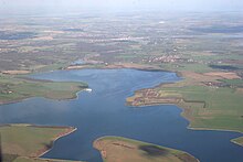
Abberton Reservoir is a pumped storage freshwater reservoir in eastern England near the Essex coast, with an area of 700 hectares (1,700 acres). Most of its water is pumped from the River Stour. It is the largest body of freshwater in Essex.

Contents

Constructed between 1935 and 1939, Abberton Reservoir is owned and managed by Essex and Suffolk Water, part of Northumbrian Water Group, and lies 6 km (3.7 mi) south-west of Colchester near the village of Layer de la Haye. In World War II, the reservoir was mined to deter invading seaplanes, and it was used by the RAF's No. 617 Squadron ("The Dam Busters") for practice runs for the bombing of the German dams in the Ruhr. A project to increase the capacity of Abberton Reservoir to 41,000 megalitres (9.0×10⁹ imp gal) by raising its bank height was completed in 2013, along with a new link to transfer water from Norfolk's River Ouse to the Stour.

The reservoir is important for its breeding cormorants, wintering and moulting waterfowl, and migrating birds. It is an internationally important wetland, designated as a Ramsar site, Site of Special Scientific Interest and Special Protection Area, and is listed in A Nature Conservation Review . A small part of the site is managed by the Essex Wildlife Trust.

History

Essex is one of the driest counties in the UK, [2] situated as it is the East of England region, the driest part of Britain. [3] The first major project to address local water needs was the establishment of the South Essex Waterworks Company in 1861, which extracted water from the underlying chalk aquifer through wells and boreholes. This supplied an area north east of London from East Ham to Grays and Brentwood. Despite the tapping of new wells, by the outbreak of World War I, the demand was outstripping supply, and eventually the need to find new sources led to the creation of a new reservoir. [4]

A 1928 Act of Parliament gave the water company the authority to plan and oversee the construction of a new reservoir to supply the local area, and further legislation in 1935 approved the necessary infrastructure in terms of pipelines to the Stour, pumping stations and a water treatment plant. [4] The reservoir was constructed between 1935 and 1939 on a site that was formerly farmland with a couple of small woods, by damming the Layer Brook, although most of its water is pumped in from the River Stour 14 km (8.7 mi) to the north east of the reservoir. [5] [6]

The 690 m (2,270 ft) dam wall was constructed using the underlying London Clay to build an impermeable puddle clay core. Layers of soil and gravel were piled on both sides of the clay core to increase the dam's strength. Existing buildings and plant life were cleared from within the reservoir basin boundaries, and the topsoil stripped and used to profile the reservoir's edges. A concrete apron and road covered 13.7 kilometres (8.5 mi) of the 17.7-kilometre (11.0 mi) perimeter. Two existing roads were kept, crossing the west end of the reservoir on causeways completed in May 1939. The reservoir originally held 25,000 megalitres (5.5×10⁹ imp gal) of water. [4]

World War II

Edersee Dam on 17 May 1943 Bundesarchiv Bild 183-C0212-0043-012, Edertalsperre, Zerstorung.jpg
Edersee Dam on 17 May 1943

Abberton Reservoir was first filled just before the start of World War II in 1939, and the Ministry of Defence was concerned that it might be used by German seaplanes as part of a possible invasion. To prevent this, 312 naval mines, anchored by steel cables, were laid in a grid across the reservoir. Steel cables were stretched across the part of the reservoir nearest to the pumping station, since exploding mines might have damaged the building. Some were inadvertently detonated by ice, but most were exploded after the war by soldiers firing from the banks. [7]

A German Heinkel bomber returning from a raid on Hornchurch airfield was shot down over Abberton on 24 August 1940. One of its crew bailed out from the burning plane and was captured; another drowned. [7]

The reservoir was used by the RAF's No. 617 Squadron ("The Dam Busters") for practice runs for attacks against German dams in the Ruhr during World War II (Operation Chastise). The reservoir was intended to simulate the Edersee Dam in Germany. [8] Lancaster bombers fitted with special bouncing bombs designed by Barnes Wallis were used in these trials, [9] and military police closed the causeway whilst the practice runs took place. [10] The last practice flight to Abberton was a full dress rehearsal of the Ruhr attack, and took place on the night of 14 May 1943. [11] The actual attack on the dams in Germany took place two nights later on 16 May 1943. [12] The Edersee Dam was attacked and breached after the Möhne dam had been successfully destroyed. [13]

Expansion

The reservoir's current owners, Essex and Suffolk Water, part of the Northumbrian Water Group, recognised by 2007 that its capacity was insufficient to meet growing local demand, [14] and initiated a £140 million project to increase the capacity to 41,000 megalitres (9.0×10⁹ imp gal) by raising its banks. The scheme was completed in 2013, [2] [5] and included replacing the existing link from the Stour to Abberton with new, higher capacity, pipes following a different route and extracting water at Wormingford instead of Stratford St. Mary. [2] [15]

The other major part of the project was to enable the transfer of water from the Ouse, 141 km (88 mi) distant in Norfolk, [6] to the reservoir via the Stour. [2] Existing pipelines and associated infrastructure such as pumping stations carried water from the Ouse at Denver to Kirtling Green. From there, a new 15.5-kilometre (9.6 mi) tunnel was constructed to Wixoe, where existing pipelines completed the transfer to the Stour. [14] [16]

The reservoir has a current maximum area of 535 ha (1,320 acres), and has three sections separated by the Layer Breton and Layer de la Haye causeways. The easternmost large, deep Main section, originally 410 hectares (1,000 acres) was enlarged to its current 535 ha (1,320 acres) in 2013, the Central section covers 49 ha (120 acres), and the Western section is 16 ha (40 acres). [5] The current maximum water depth is about 17 m (56 ft), 3.2 m (10 ft) more than before the enlargement. [2]

In wet years, Abberton and the other major Essex reservoir at Hanningfield can meet the requirements of the 750,000 people they serve in Essex and north east London using only water from the Stour and other local sources, but in average years 7% of the inflow involves transfers from the Ouse, rising to 35% in times of drought. [17] [14]

Ecology

LBC Layer Breton Causeway
LDHC Layer de la Haye Causeway

.mw-parser-output .legend{page-break-inside:avoid;break-inside:avoid-column}.mw-parser-output .legend-color{display:inline-block;min-width:1.25em;height:1.25em;line-height:1.25;margin:1px 0;text-align:center;border:1px solid black;background-color:transparent;color:black}.mw-parser-output .legend-text{}
Nature reserve
Paths and bird hides
Visitor Centre Abberton Reservoir.jpg
LBC Layer Breton Causeway
LDHC Layer de la Haye Causeway
   Nature reserve    Paths and bird hides    Visitor Centre

Abberton Reservoir, the largest body of freshwater in Essex, lies 6 km (3.7 mi) south-west of Colchester near the village of Layer de la Haye and less than 8 km (5.0 mi) from the coast. [5] The Western and Central sections of Abberton Reservoir have natural shores with common reed and willow close to the water, grading into damp grassland and cultivated fields. The Main part originally had concrete borders, but 12 kilometres (7.5 mi) of this apron and the perimeter road were broken up in the expansion between 2010 and 2013. Most of the edge was re-profiled to make it more attractive to water birds, and along with 200 hectares (490 acres) of adjacent land, it is now managed by Essex and Suffolk Water and the Essex Wildlife Trust to increase biodiversity. [5]

The new design created pools around the borders of the reservoir and allowed for creation of marshland west of the Layer de la Haye causeway. A culvert under the causeway was blocked, allowing the water level in the western sections to be controlled independently of the main body of water. [2]

Birds

Abberton is internationally important for gadwalls (male shown) Gadwall-Anas-strepera.jpg
Abberton is internationally important for gadwalls (male shown)

Abberton had been a winter roosting site for cormorants from the 1950s, and became the first tree-nesting colony in England when eight pairs bred there in 1981. There were 584 pairs by 1993, although numbers have since declined to around 180 pairs. Little egrets first nested in 2014, numbering 31 pairs by 2019, and a pair of cattle egrets bred in 2020. The area holds around 20 pairs each of Cetti's warblers and nightingales. Typical farmland species such as the corn bunting, yellowhammer and barn owl also breed in the protected areas. Up to eight pairs of little ringed plovers breed on the re-profiled margins of the reservoir. [5]

Abberton is a major site for wintering wildfowl, and has the largest numbers of any UK inland water body, typically holding around 35,000 individual birds, but rising to well over 40,000 in hard winters. It is of international importance for wintering gadwalls, shovelers and wigeons, and of national importance for mute swans, teal, pochards, tufted ducks, goldeneyes, coots and great crested grebes. Many ducks also moult during their stay at the reservoir. There are significant numbers of waders in winter, including black-tailed godwits, ruffs, lapwings and golden plovers. [5] In winter, bitterns occur regularly at the western end of the reservoir, and hen harriers, merlins, peregrine falcons and marsh harriers hunt over the bordering grassland; the last species has sometimes summered. [5]

Its proximity to the coast means that Abberton may hold scarcer species like smews and long-tailed ducks, and rarities including a blue-winged teal (1996), Britain's first canvasback (1997–2001) and a lesser scaup (2004–2005). [5] Rare terns include gull-billed, which bred in 1949 and 1950, Caspian, whiskered and white-winged black, five of the last species being present together in May 2019. Other recent rarities include ortolan bunting (2019), Bonaparte's gull (2017, 2019) Franklin's gull (2016) and desert wheatear (2012). There have been multiple records of red-footed falcons and red-rumped swallows over the years. [5]

A bird ringing scheme has operated at Abberton for more than 70 years, 90,000 ducks having been ringed in that period, including 40,000 teal. Recoveries of ringed birds have established national longevity records for 10 species, including wigeon (34 years), pochard (22 years) and gadwall (21 years). [5]

Other wildlife

Anthribus fasciatus Anthribus.fasciatus.-.calwer.30.16.jpg
Anthribus fasciatus

Abberton has otters, water voles and brown hares, and eight species of bats, and other vertebrates include the common lizard, grass snake and great crested newt. Insects present include two rare weevils, Rhynchites auratus , which feeds on blackthorn, and a fungus specialist, Anthribus fasciatus . [5]

Introduced American signal crayfish are a problem in that they are larger and more prolific breeders than the native white-clawed crayfish, and eventually displace the latter species. They also burrow into river banks, which at Abberton may reduce the area available for aquatic vegetation and increase the amount of sediment entering the reservoir from the Layer Brook. [18]

Protection

Abberton was designated a Special Protection Area on 5 December 1991 as a result of its over-wintering populations of golden plovers, gadwalls, shovelers and teals, and for its breeding population of cormorants. There are also significant numbers of black-tailed godwits, lapwings, coots, goldeneyes, [19] tufted ducks, pochards, pintails, wigeons and great crested grebes. [19]

It is an internationally important wetland that was designated as a Ramsar site in 1981, [1] [20] and became a Site of Special Scientific Interest in 1988, [21] [22] three years after Hanningfield Reservoir received the same status. [23]

A small part of the site is managed as a nature reserve by the Essex Wildlife Trust. [24]

Access

Abberton Visitor Centre Abberton Visitor Centre - geograph.org.uk - 242349.jpg
Abberton Visitor Centre

The Essex Wildlife Trust has a car park and nature reserve, the Abberton Reservoir Nature Discovery Park, at the north end of the Layer de la Haye causeway. There is a visitor centre with a shop, café, toilets and play area, and three bird hides, two looking south and east over the Main section, and one in woodland. The visitor centre and reserve are open every day from 10 am–5 pm as of 2021. [24]

The western and central sections can be viewed from the Layer Breton and Layer de la Haye causeways, the latter also giving views of the main section. There is no public access to the western section, but a car park at the southern end of the Layer de la Haye causeway gives access to a viewing screen and scrapes (vegetation-free areas of mud) for waders on the main section. Parts of the rest of the main section can be seen from public footpaths and St Andrews Church in Abberton village. [5]

Related Research Articles

<span class="mw-page-title-main">Old Bedford River</span> Watercourse in Cambridgeshire, England

The Old Bedford River is an artificial, partial diversion of the waters of the River Great Ouse in the Fens of Cambridgeshire, England. It was named after the fourth Earl of Bedford who contracted with the local Commission of Sewers to drain the Great Level of the Fens beginning in 1630. It provided a steeper and shorter path for the waters of the Great Ouse, and was embanked to prevent them flooding the low ground of the South Fens. Throughout the project, the Earl and his Adventurers faced disruption from those who were opposed to drainage schemes. The project was deemed to have succeeded in draining the fens in 1637, but that decision was reversed in 1638. After a lull during the English Civil War, when much of the work was damaged, the Dutch engineer Cornelius Vermuyden worked with William Russell, the fifth Earl of Bedford to complete the drainage. Disruption and unrest continued while the work was carried out, resulting in the Adventurers employing armed guards. A second river, the New Bedford River, was cut parallel to the first channel, which then became the Old Bedford River. At some point, the Old Bedford River was split into two parts, when the upper section was diverted into the River Delph at Welches Dam, and the lower section was joined to the Counter Drain. Both parts retain the name, but are not connected to each other. The area between the two Bedford rivers acts as a large washland, which holds floodwater when the river channels cannot cope with the volume of water in them.

<span class="mw-page-title-main">Ouse Washes</span> Nature reserve in the United Kingdom

Ouse Washes is a linear 2,513.6-hectare (6,211-acre) biological Site of Special Scientific Interest stretching from near St Ives in Cambridgeshire to Downham Market in Norfolk. It is also a Ramsar internationally important wetland site, a Special Protection Area for birds, a Special Area of Conservation and a Nature Conservation Review site, Grade I. An area of 186 hectares between March and Ely is managed by the Wildlife Trust for Bedfordshire, Cambridgeshire and Northamptonshire and another area near Chatteris is managed by the Royal Society for the Protection of Birds. The Wildfowl & Wetlands Trust manages another area near Welney.

<span class="mw-page-title-main">Essex Wildlife Trust</span> Wildlife conservation charity

The Essex Wildlife Trust (EWT) is one of 46 wildlife trusts which cover the United Kingdom. The EWT was founded in 1959, and it describes itself as Essex's leading conservation charity, which aims to protect wildlife for the future and the people of the county. As of January 2017, it has over 34,000 members and runs 87 nature reserves, 2 nature parks and 11 visitor centres.

<span class="mw-page-title-main">Grafham Water</span> Reservoir in Cambridgeshire

Grafham Water is an 806.3-hectare (1,992-acre) biological Site of Special Scientific Interest (SSSI) north of Perry, Huntingdonshire. It was designated an SSSI in 1986. It is a reservoir with a circumference of about 16 km (10 mi), is 21 m (69 ft) deep at maximum, and is the eighth largest reservoir in England by volume and the third largest by area at 6.27 km2. An area of 114 ha at the western end is a nature reserve managed by the Wildlife Trust for Bedfordshire, Cambridgeshire and Northamptonshire.

<span class="mw-page-title-main">Gandhi Sagar Dam</span> Dam in Mandsaur District Madhya Pradesh

GandhisagarDam is situated at a distance of 168 km from the District headquarter. The Dam is constructed on the Chambal River.

<span class="mw-page-title-main">California State Water Project</span> Flood control, energy production, and water conveyance infrastructure

The California State Water Project, commonly known as the SWP, is a state water management project in the U.S. state of California under the supervision of the California Department of Water Resources. The SWP is one of the largest public water and power utilities in the world, providing drinking water for more than 27 million people and generating an average of 6,500 GWh of hydroelectricity annually. However, as it is the largest single consumer of power in the state itself, it has a net usage of 5,100 GWh.

<span class="mw-page-title-main">Hirakud Dam</span> Dam in Odisha, India

Hirakud Dam is built across the Mahanadi River, about 15 kilometres (9 mi) from Sambalpur in the state of Odisha in India. It is the longest earthen dam in the world. Behind the dam extends a lake, Hirakud Reservoir, 55 km (34 mi) long. It is one of the first major multipurpose river valley projects started after India's independence. Hirakud Reservoir was declared a Ramsar site on 12 October 2021.

<span class="mw-page-title-main">Maharana Pratap Sagar</span> Reservoir in India

Maharana Pratap Sagar, also known as Pong Reservoir or Pong Dam Lake is a large reservoir in Fatehpur, Jawali and Dehra tehsil of Kangra district of the state of Himachal Pradesh in India. It was created in 1975, by building the highest earthfill dam in India on the Beas River in the wetland zone of the Siwalik Hills. Named in the honour of Maharana Pratap (1540–1597), the reservoir or the lake is a well-known wildlife sanctuary and one of the 49 international wetland sites declared in India by the Ramsar Convention. The reservoir covers an area of 24,529 hectares, and the wetlands portion is 15,662 hectares.

<span class="mw-page-title-main">Lake Qaraoun</span> Multipurpose reservoir in Beqaa Valley

Lake Qaraoun is an artificial lake or reservoir located in the southern region of the Beqaa Valley, Lebanon. It was created near Qaraoun village in 1959 by building a 61 m-high (200 ft) concrete-faced rockfill dam in the middle reaches of the Litani River. The reservoir has been used for hydropower generation, domestic water supply, and for irrigation of 27,500 ha.

<span class="mw-page-title-main">Hanningfield Reservoir</span> Reservoir in Essex, United Kingdom

Hanningfield Reservoir is a large 25,500-million-litre (900,000,000 cu ft) pumped storage reservoir located between Billericay and Chelmsford in Essex. It has a surface area of 352 hectares and is owned and operated by Essex and Suffolk Water.

The Orielton Lagoon is a shallow dystrophic lagoon located west of Sorell in south east Tasmania, Australia.

<span class="mw-page-title-main">Split Rock Dam</span> Dam in North West Slopes, New South Wales

Split Rock Dam is a minor ungated concrete faced rock fill embankment dam with concrete chute spillway across the Manilla River upstream of Manilla in the north-western slopes region of New South Wales, Australia. The dam's purpose includes flood mitigation, irrigation, water supply and conservation. The impounded reservoir is called Split Rock Reservoir.

<span class="mw-page-title-main">Ujjani Dam</span> Dam in Madha Taluka, Solapur district

Ujjani Dam, also known as Bhima Dam or Bhima Irrigation Project, on the Bhima River, a tributary of the Krishna River, is an earthfill cum Masonry gravity dam located near Ujjani village of Madha Taluk in Solapur district of the state of Maharashtra in India.

<span class="mw-page-title-main">Jayakwadi Dam</span> Dam in Maharashtra, India

Jayakwadi dam is an earthen dam located on Godavari river at the site of Jayakwadi village in Paithan taluka of Sambhajinagar district in Maharashtra, India. It is a multipurpose project. The water is mainly used to irrigate agricultural land in the drought-prone Marathwada region of the state. It also provides water for drinking and industrial usage to nearby towns and villages and to the municipalities and industrial areas of Sambhajinagar and Jalna districts. The surrounding area of the dam has a garden and a bird sanctuary.

<span class="mw-page-title-main">Lake Hodges</span> A reservoir in San Diego, California.

Lake Hodges is a lake and reservoir located within the city limits of San Diego, California. It is about 31 miles (50 km) north of Downtown San Diego, just north of the Rancho Bernardo community, and just south of the city's border with Escondido. When full, the reservoir has 1,234 acres (4.99 km2), a maximum water depth of 115 feet (35 m), and 27 miles (43 km) of shoreline. Lake Hodges has a total capacity of 30,251 acre-feet of water. Lake Hodges is owned by the city of San Diego, supplies water to the San Dieguito Water District and Santa Fe Irrigation District, and its mailing city address is Escondido.

<span class="mw-page-title-main">Siah Bishe Pumped Storage Power Plant</span> Dam in Chalus

The Siah Bisheh Pumped Storage Power Plant, also spelled Siyāhbisheh and Siah Bishe, is located in the Alborz Mountain range near the village of Siah Bisheh and 48 km (30 mi) south of Chalus in Mazandaran Province, Iran. The power plant uses the pumped-storage hydroelectric method to generate electricity during periods of high energy demand, making it a peaking power plant, intended to fulfill peak electricity demand in Tehran 60 km (37 mi) to the south. When complete it will have an installed generating capacity of 1,040 megawatts (1,390,000 hp) and a pumping capacity of 940 megawatts (1,260,000 hp). Planning for the project began in the 1970s and construction began in 1985. It was delayed from 1992 until 2001 and the first generator went online in May 2013. The remaining generators were commissioned by 1 September 2015. The power plant is the first pumped-storage type in Iran and will also use the country's first concrete-face rock-fill dam – two of them.

Essex and Suffolk Water is a water supply company in the United Kingdom. It operates in two geographically distinct areas, one serving parts of Norfolk and Suffolk, and the other serving parts of Essex and Greater London. The total population served is 1.8 million. Essex and Suffolk is a 'water only' supplier, with sewerage services provided by Anglian Water and Thames Water within its areas of supply. It is part of the Northumbrian Water Group.

<span class="mw-page-title-main">Roman River</span> River in Essex, England

The Roman River is a river that flows entirely through the English county of Essex. It is a tributary of the River Colne, flowing into its tidal estuary below Colchester. The lower end of the Roman River is also tidal, with tidal water flowing upstream to just above Fingringhoe.

<span class="mw-page-title-main">Cut-off Channel</span> River in England

The Cut-off Channel is a man-made waterway which runs along the eastern edge of the Fens in Norfolk and Suffolk, England. It was constructed in the 1950s and 1960s as part of flood defence measures, and carries the headwaters of the River Wissey, River Lark and River Little Ouse in times of flood, delivering them to Denver Sluice on the River Great Ouse. In the summer months, it is also used as part of a water supply scheme for drinking water in Essex.

References

  1. 1 2 "Abberton Reservoir". Ramsar Sites Information Service. Archived from the original on 30 May 2018. Retrieved 25 April 2018.
  2. 1 2 3 4 5 6 "Project Focus: Abberton Reservoir enlargement". WWT – Water & Wastewater Treatment. 22 May 2015. Archived from the original on 21 January 2021. Retrieved 5 July 2021.
  3. "Eastern England: climate" (PDF). Met Office. 11 October 2016. Archived (PDF) from the original on 1 August 2021. Retrieved 22 May 2021.
  4. 1 2 3 Abberton Reservoir expansion project pp.6–7.
  5. 1 2 3 4 5 6 7 8 9 10 11 12 13 Holt, Chas; Wallis, Kim; Durham, Maurice; Ekins, Graham; Hearn, Richard; King, Roy (2020). "Great bird reserves: Abberton Reservoir". British Birds. 113 (11): 686–704.
  6. 1 2 Abberton Reservoir expansion project pp.9–10.
  7. 1 2 Abberton Reservoir expansion project p. 11.
  8. Sweetman, John (1982). Operation Chastise: The Dams Raid : Epic Or Myth. Jane's. p. 65. ISBN   978-0-86-720557-2.
  9. "The Incredible Story of the Dambusters Raid". Imperial War Museums. Archived from the original on 28 October 2020. Retrieved 31 October 2020.
  10. "Abberton Reservoir – what was there before". Mersea Museum. Archived from the original on 6 November 2020. Retrieved 31 October 2020.
  11. Holland, James (2013). Dam Busters: The True Story of the Inventors and Airmen Who Led the Devastating Raid to Smash the German Dams in 1943. Grove/Atlantic, Inc. pp. 267–268. ISBN   978-0-8021-9306-3.
  12. Lukasik, Sebastian H. "The triumph, and horror, of the Royal Air Force's 1943 'Dambusters Raid'". Washington Post (Review). ISSN   0190-8286. Archived from the original on 14 March 2020. Retrieved 31 October 2020.
  13. Harwood, Jeremy (2014). World War II From Above: An Aerial View of the Global Conflict. Voyageur Press. p. 127. ISBN   978-1-62788-236-1.
  14. 1 2 3 "The Abberton Scheme Environmental Statement Non-technical Summary" (PDF). Northumbrian Water. December 2007. Archived (PDF) from the original on 1 August 2021. Retrieved 10 November 2020.
  15. Jenkins, Jim. "Abberton Scheme: Wormingford Pumping Station" (PDF). Water Projects Online. Archived (PDF) from the original on 19 May 2021. Retrieved 20 May 2021.
  16. Jenkins, Jim. "Abberton Pipelines Project" (PDF). Water Projects Online. Archived (PDF) from the original on 20 May 2021. Retrieved 21 May 2021.
  17. Wilson, Daniel (2012). "Abberton Reservoir Enhancement" (PDF). Water Projects Online. Archived (PDF) from the original on 20 May 2021. Retrieved 22 May 2021.
  18. Acres, Miranda (10 March 2017). "Project Topsoil: Layer Brook and Abberton Reservoir". Essex and Suffolk Rivers Trust. Archived from the original on 19 May 2021. Retrieved 19 May 2021.
  19. 1 2 "Abberton Reservoir" (PDF). Natura 2000 Standard Data Form. Joint Nature Conservation Committee. Archived (PDF) from the original on 27 September 2020. Retrieved 4 November 2020.
  20. "Designated and Proposed Ramsar sites in the UK and Overseas Territories & Crown Dependencies". Joint Nature Conservation Committee. Archived from the original on 20 November 2015. Retrieved 19 November 2015.
  21. "Abberton Reservoir SSSI". Sites of Special Scientific Interest. Natural England. Archived from the original on 25 May 2021. Retrieved 25 May 2021.
  22. "Map of Abberton Reservoir". Sites of Special Scientific Interest. Natural England. Archived from the original on 4 March 2016. Retrieved 30 October 2015.
  23. "Hanningfield Reservoir SSSI". Sites of Special Scientific Interest. Natural England. Archived from the original on 25 May 2021. Retrieved 25 May 2021.
  24. 1 2 "Abberton Reservoir Visitor Centre". Essex Wildlife Trust. Archived from the original on 26 March 2018. Retrieved 4 November 2020.

Cited works