
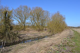
Ingrebourne Valley is a local nature reserve (LNR) in Hornchurch in the London Borough of Havering. It is owned and managed by Havering Council, and has a visitor centre managed by the Essex Wildlife Trust. Most of it is in Hornchurch Country Park west of the River Ingrebourne, but there are also areas north and south of the park which are part of the LNR. It has a wide range of habitats, including woodland, grassland, the river and marshes. It is an important site for a range of species of plants, animals and birds, including great crested newts, slow worms, the harvest mouse and the water vole.

Ingrebourne Marshes are a 74.8 hectare biological Site of Special Scientific Interest in Hornchurch in the London Borough of Havering. Ingrebourne Valley Local Nature Reserve includes a small part of the SSSI west of the River Ingrebourne. The site is managed by the Essex Wildlife Trust

Roding Valley Meadows is an 18.9 hectare biological Site of Special Scientific Interest in Buckhurst Hill in Essex. It is part of a 65.2 hectare Local Nature Reserve with the same name, which is owned by Epping Forest District Council and Grange Farm Trust, and managed by the Essex Wildlife Trust.

Cranham Marsh is a 15.3 hectare Local Nature Reserve and a Site of Metropolitan Importance for Nature Conservation in Cranham in the London Borough of Havering. It is owned by Havering Council and managed by the Essex Wildlife Trust.

Sawbridgeworth Marsh is a 6.3 hectare biological Site of Special Scientific Interest (SSSI) near Sawbridgeworth in Hertfordshire, apart from a small area in the north which is in Essex. It is managed by the Essex Wildlife Trust. The planning authorities are East Hertfordshire District Council and Uttlesford District Council.
Thorley Wash or Thorley Flood Pound is a 17.3 hectare biological Site of Special Scientific Interest in Thorley, south of Bishop's Stortford in Hertfordshire. It was formerly a flood pound for the Stort Navigation, which was decommissioned in 2004 and converted to a more natural state. It was purchased by the Herts and Middlesex Wildlife Trust from the Environment Agency in 2011.

The Crouch and Roach Estuaries are a 1729 hectare biological Site of Special Scientific Interest (SSSI) at the mouth of the Crouch and Roach rivers in Essex. The Crouch part of the SSSI stretches from near Battlesbridge to Foulness Island, and the Roach from Rochford to the junction with the Crouch. Part of the site is in the Mid-Essex Coast Special Protection Area under the EC Directive on the Conservation of Wild Birds, and a Ramsar wetland site of international importance. It is also part of the Essex Estuaries Special Area of Conservation. An area of 65 hectares is managed by the Essex Wildlife Trust as the Lion Creek and Lower Raypits nature reserve and 8 hectares at Woodham Fen, both of which are managed by the Essex Wildlife Trust. A small area is also a geological SSSI, The Cliff, Burnham-on-Crouch.

Danbury Ridge Nature Reserves are a group of nature reserves totalling 101 hectares near Danbury in Essex. They are managed by the Essex Wildlife Trust, and most of them are in Sites of Special Scientific Interest (SSSIs). Two areas, the Backwarden and Hitchcock's Meadow, are part of Danbury Common SSSI, and Woodham Walter Common, Birch Wood, Pheasanthouse Wood, Poors Piece, Scrubs Wood, and a small area in Pheasanthouse Farm, are part of Woodham Walter Common SSSI.

Foulness SSSI is a 10,702 hectare biological Site of Special Scientific Interest covering the shoreline between Southend-on-Sea and the Crouch estuary in Essex. It is a key site in A Nature Conservation Review, and is part of the Essex Estuaries Special Area of Conservation. It covers two Ramsar wetland sites of international importance, 'Crouch and Roach Estuaries' and 'Foulness'. An area of 6.4 hectares is Shoeburyness Old Ranges, a Local Nature Reserve managed by the Essex Wildlife Trust.

Hamford Water is a 2,185.8-hectare (5,401-acre) biological Site of Special Scientific Interest between Walton-on-the-Naze and Harwich in Essex. The site is a tidal inlet which has marsh grasslands, creeks, mud and sand flats, salt marshes, islands and beaches. It is described by Natural England as "of international importance for breeding little terns and wintering dark-bellied brent geese, wildfowl and waders, and of national importance for many other bird species." Rare plants include hog's fennel and slender hare's-ear. The main invertebrates are worms and thin-shelled molluscs. The largest island, Horsey Island, can be reached on foot at low tide across The Wade from Kirby-le-Soken.

Fenn Washland is a 4.9 hectare Local Nature Reserve in South Woodham Ferrers in Essex. It is owned by Essex County Council and managed by the Council as a part of the nearby Marsh Farm Country Park.
Lexden Gathering Grounds is an 8.9 nature reserve in Lexden, a suburb of Colchester in Essex. It is owned by Anglian Water and managed by the Essex Wildlife Trust.

Vange and Fobbing Marshes are a 164.6 hectarre biological Site of Special Scientific Interest in two areas south of Basildon in Essex. Vange Marsh is managed by the Royal Society for the Protection of Birds.

Chigborough Lakes is an 18.6 hectare nature reserve in Maldon in Essex. It is managed by the Essex Wildlife Trust.

Gernon Bushes is a 32 hectare nature reserve north-east of Epping in Essex. It is managed by the Essex Wildlife Trust. It is part of the Epping Forest Site of Special Scientific Interest and Nature Conservation Review site.

Lion Creek and Lower Raypits is a 65.2 hectare nature reserve east of Canewdon in Essex. It is part of the Crouch and Roach Estuaries Site of Special Scientific Interest, and is owned and managed by the Essex Wildlife Trust.

Roman River Valley is a 17.8 hectare nature reserve north of Layer de la Haye in Essex. It is managed by the Essex Wildlife Trust.

Stanford Warren is a 16.6 hectare nature reserve south of Stanford-le-Hope in Essex. It is managed by the Essex Wildlife Trust.
Stow Maries Halt is a 2.2 hectare nature reserve south of Stow Maries in Essex. It is owned and managed by the Essex Wildlife Trust.

Tollesbury Wick is a 242.8 hectare nature reserve east of Tollesbury in Essex. It is managed by the Essex Wildlife Trust.


