
The Essex Wildlife Trust (EWT) is one of 46 wildlife trusts which cover the United Kingdom. The EWT was founded in 1959, and it describes itself as Essex's leading conservation charity, which aims to protect wildlife for the future and the people of the county. As of January 2017, it has over 34,000 members and runs 87 nature reserves, 2 nature parks and 11 visitor centres.
Wallasea Island lies in Essex, England. It is bounded to the north by the River Crouch, to the south east by the River Roach, and to the west by Paglesham Pool and the narrow Paglesham Creek. The population of the Island is included in the civil parish of Canewdon.

Wallasea Wetlands is a reclaimed wetlands area located in Essex, England. It has been created as part of a government-funded wetlands scheme to halt the decline of wild and endangered birds caused by the drainage and development of former wetland sites. It is the largest man-made marine wetland area in the United Kingdom.
Dengie nature reserve is a 12 sq. mi. biological and geological Site of Special Scientific Interest between the estuaries of the Blackwater and Crouch near Bradwell-on-Sea in Essex. It is also a National Nature Reserve, a Special Protection Area, a Nature Conservation Review site, a Geological Conservation Review site and a Ramsar site. It is part of the Essex estuaries Special Area of Conservation. An area of 30 acres is the Bradwell Shell Bank nature reserve, which is managed by the Essex Wildlife Trust.

Bridgemarsh Island is in the tidal part of the River Crouch in the English county of Essex, three miles upstream from Burnham-on-Crouch. The main river channel runs to the south between the island and Canewdon, and it is separated from the mainland to the north by Bridgemarsh and Althorne Creeks, channels of the estuary.

Colne Estuary is a 2915 hectare biological and geological Site of Special Scientific Interest near Brightlingsea in Essex. It is also a Nature Conservation Review site, a National Nature Reserve, a Ramsar wetland site of international importance, a Special Protection Area, a Special Area of Conservation, and a Geological Conservation Review site. Three areas in the site are managed by the Essex Wildlife Trust, Colne Point, Fingringhoe Wick and Howlands Marsh.

The Tamar–Tavy Estuary is a Site of Special Scientific Interest (SSSI) covering the tidal estuaries of the River Tamar and the River Tavy on the border between Cornwall and Devon in England, UK. Part of the Tamar estuary also forms the Tamar Estuary Nature Reserve, owned by the Cornwall Wildlife Trust. The site was designated in 1991 for its biodiversity and varying habitats that support many wader and wildfowl species, as well as the special interest of its marine biology.
Thorley Wash or Thorley Flood Pound is a 17.3-hectare biological Site of Special Scientific Interest in Thorley, south of Bishop's Stortford in Hertfordshire. It was formerly a flood pound for the Stort Navigation, which was decommissioned in 2004 and converted to a more natural state. It was purchased by the Herts and Middlesex Wildlife Trust from the Environment Agency in 2011.

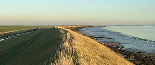
The Crouch and Roach Estuaries are a 1729 hectare biological Site of Special Scientific Interest (SSSI) at the mouth of the Crouch and Roach rivers in Essex. The Crouch part of the SSSI stretches from near Battlesbridge to Foulness Island, and the Roach from Rochford to the junction with the Crouch. Part of the site is in the Mid-Essex Coast Special Protection Area under the EC Directive on the Conservation of Wild Birds, and a Ramsar wetland site of international importance. It is also part of the Essex Estuaries Special Area of Conservation. An area of 65 hectares is managed by the Essex Wildlife Trust as the Lion Creek and Lower Raypits nature reserve and 8 hectares at Woodham Fen, both of which are managed by the Essex Wildlife Trust. A small area is also a geological SSSI, The Cliff, Burnham-on-Crouch.

Foulness SSSI is a 10,702 hectare biological Site of Special Scientific Interest covering the shoreline between Southend-on-Sea and the Crouch estuary in Essex.

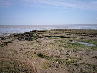
The Cliff, Burnham-on-Crouch is a 4 hectare geological Site of Special Scientific Interest (SSSI) on the bank of the River Crouch between Burnham-on-Crouch and North Fambridge in Essex. It is also part of the biological SSSI, Crouch and Roach Estuaries. It is a Geological Conservation Review site both for its fossil birds and for its fishes and amphibians.

Blue House Farm is a 242.8-hectare (600-acre) nature reserve and farm in North Fambridge, on the north bank of the River Crouch between Burnham-on-Crouch and South Woodham Ferrers in Essex. It is managed by the Essex Wildlife Trust. Most of the site is in of the Crouch and Roach Estuaries Site of Special Scientific Interest.

Abbotts Hall Farm is a 282 hectare nature reserve in Great Wigborough in Essex. It is the head office of the Essex Wildlife Trust, which manages the site. It is also part of the Blackwater Estuary National Nature Reserve, Site of Special Scientific Interest, Ramsar site, Special Protection Area and Special Area of Conservation, It is an important archaeological site, and includes a Scheduled Monument, Great Wigborough henge.

Bradwell Shell Bank is a nature reserve on the coast of the Dengie Peninsula near Bradwell-on-Sea in Essex. It is managed by the Essex Wildlife Trust. It is part of the Dengie Site of Special Scientific Interest, Special Protection Area and Ramsar site, and the Essex Estuaries Special Area of Conservation. It is also part of the Blackwater Flats and Marshes, a Grade I site in the Nature Conservation Review.

Colne Point is a 276.4-hectare (683-acre) nature reserve south-west of St Osyth in Essex. It is managed by the Essex Wildlife Trust. It is part of the Colne Estuary Site of Special Scientific Interest, national nature reserve, Ramsar site, Nature Conservation Review site and Special Protection Area. It is also part of the Essex Estuaries Special Area of Conservation.

Howlands Marsh is a 29.9-hectare (74-acre) nature reserve north-east of St Osyth in Essex. It is managed by the Essex Wildlife Trust. It is part of the Colne Estuary Site of Special Scientific Interest Special Protection Area and Ramsar site, and the Blackwater Flats and Marshes Nature Conservation Review site.

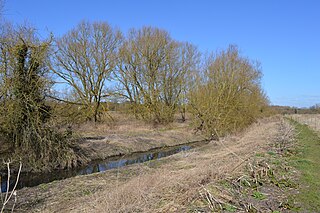
Woodham Fen is an 8.1-hectare (20-acre) nature reserve in South Woodham Ferrers in Essex. It is managed by the Essex Wildlife Trust. It is part of the Crouch and Roach Estuaries Site of Special Scientific Interest.

South Thames Estuary and Marshes is a 5,289-hectare (13,070-acre) biological Site of Special Scientific Interest which stretches between Gravesend and the mouth of the River Medway in Kent. Part of it is a Nature Conservation Review site, Grade I, and part is a Royal Society for the Protection of Birds nature reserve. It is part of the Thames Estuary and Marshes Ramsar internationally important wetland site and Special Protection Area under the European Union Directive on the Conservation of Wild Birds.

Hurst Castle and Lymington River Estuary is a 1,077.3-hectare (2,662-acre) biological and geological Site of Special Scientific Interest near Lymington in Hampshire. It is a Nature Conservation Review site and two areas are Geological Conservation Review sites. Three areas are local nature reserves, Boldre Foreshore, Sturt Pond and Lymington and Keyhaven Marshes; the latter site is managed by the Hampshire and Isle of Wight Wildlife Trust. Part of it is North Solent National Nature Reserve. It is part of Solent and Southampton Water Ramsar site and Special Protection Area. Parts of it are in Solent Maritime and Solent and Isle of Wight Lagoons Special Areas of Conservation.

