
The Borough of Colchester is a local government district and borough, with city status, in Essex, England, named after its main city, Colchester. The borough covers an area of 125 square miles (320 km2) and stretches from Dedham Vale on the Suffolk border in the north to Mersea Island on the Colne Estuary in the south.
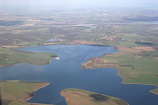
Abberton Reservoir is a pumped storage freshwater reservoir in eastern England near the Essex coast, with an area of 700 hectares. Most of its water is pumped from the River Stour. It is the largest body of freshwater in Essex.

Fingringhoe is a village and civil parish in Essex, England, located five miles south-east of Colchester. The centre of the village is classified as a conservation area, featuring a traditional village pond and red telephone box. The Roman River flows nearby before entering the River Colne. It has been noted frequently on lists of unusual place names. The village's name actually derives from its geographic circumstances: it sits at the confluence of the smaller Roman River and the River Colne. A "hoe" refers to a jutting out piece of land while "finger" describes an elongated finger-like land extension. "Ing" is a common toponym in the UK referring to "peoples". As such, the name refers to the "people living on the land jutting out into the river".

Ingrebourne Valley is a local nature reserve (LNR) in Hornchurch in the London Borough of Havering. It is owned and managed by Havering Council, and has a visitor centre managed by the Essex Wildlife Trust. Most of it is in Hornchurch Country Park west of the River Ingrebourne, but there are also areas north and south of the park which are part of the LNR. It has a wide range of habitats, including woodland, grassland, the river and marshes. It is an important site for a range of species of plants, animals and birds, including great crested newts, slow worms, the harvest mouse and the water vole.

Ingrebourne Marshes are a 74.8 hectare biological Site of Special Scientific Interest in Hornchurch in the London Borough of Havering. Ingrebourne Valley Local Nature Reserve includes a small part of the SSSI west of the River Ingrebourne. The site is managed by the Essex Wildlife Trust

Layer Marney is a village and civil parish near to Tiptree, in the Colchester borough, in the county of Essex, England. Layer Marney has a Tudor palace called Layer Marney Tower and a church called Church of St Mary the Virgin. In 2001 the population of the civil parish of Layer Marney was 206.

Frays Farm Meadows is a 28.2-hectare (70-acre) biological Site of Special Scientific Interest near Denham in the London Borough of Hillingdon. It was notified as an SSSI in 1981, and has been managed by the London Wildlife Trust on behalf of Hillingdon Council since 1999. It is part of the Colne Valley Regional Park.

Roding Valley Meadows is an 18.9-hectare (47-acre) biological Site of Special Scientific Interest in Buckhurst Hill in Essex. It is part of a 65.2 hectare Local Nature Reserve with the same name, which is owned by Epping Forest District Council and Grange Farm Trust, and managed by the Essex Wildlife Trust.

Hunsdon Mead is a 34 hectare biological Site of Special Scientific Interest (SSSI) west of Harlow and east of Roydon in Essex. The site is partly in Essex and partly in Hertfordshire, and it is jointly owned and managed by the Essex Wildlife Trust and the Herts and Middlesex Wildlife Trust. The SSSI also includes part of the neighbouring Roydon Mead. The planning authorities are East Hertfordshire District Council and Epping Forest District Council. Hunsdon Mead is registered common land.

Sawbridgeworth Marsh is a 6.3-hectare (16-acre) biological Site of Special Scientific Interest (SSSI) near Sawbridgeworth in Hertfordshire, apart from a small area in the north which is in Essex. It is managed by the Essex Wildlife Trust. The planning authorities are East Hertfordshire District Council and Uttlesford District Council.
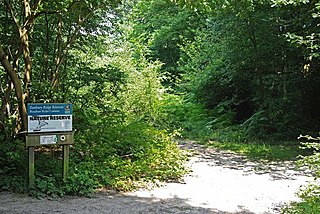
Woodham Walter Common SSSI is an 80-hectare (200-acre) biological Site of Special Scientific Interest (SSSI) in Danbury in Essex. The site includes six nature reserves within the Danbury Ridge Nature Reserves, managed by the Essex Wildlife Trust. These are Woodham Walter Common itself, Birch Wood, Pheasanthouse Wood, Poors' Piece, Scrubs Wood and a small area in Pheasanthouse Farm. The largest part of the SSSI is the 32.3-hectare (80-acre) Woodham Walter Common, which is managed by the Wildlife Trust on behalf of Maldon District Council and Woodham Walter Parish Council.

West Wood is a 23.6 hectares biological Site of Special Scientific Interest in Little Sampford, north of Thaxted in northwestern Essex. It is owned and managed by the Essex Wildlife Trust.

Weeleyhall Wood is a 31 hectare biological Site of Special Scientific Interest north of Clacton-on-Sea in Essex. It is managed by the Essex Wildlife Trust.
Horndon Meadow is a 0.8-hectare (2.0-acre) nature reserve north of Stanford-le-Hope in Essex. It is managed by the Essex Wildlife Trust.

Little Waltham Meadows is an 8.9-hectare (22-acre) nature reserve south of Little Waltham in Essex. It is owned and managed by the Essex Wildlife Trust.

Newland Grove is a 3.2-hectare (7.9-acre) nature reserve north of Chelmsford in Essex. It is managed by the Essex Wildlife Trust.

Shotgate Thickets is a 3.2-hectare (7.9-acre) nature reserve east of Wickford in Essex. It is managed by the Essex Wildlife Trust.

Tollesbury Wick is a 242.8-hectare (600-acre) nature reserve east of Tollesbury in Essex. It is managed by the Essex Wildlife Trust.

Westhouse Wood is a 2.8-hectare (6.9-acre) nature reserve north-west of Colchester in Essex. It is managed by the Essex Wildlife Trust.

The Roman River is a river that flows entirely through the English county of Essex. It is a tributary of the River Colne, flowing into its tidal estuary below Colchester. The lower end of the Roman River is also tidal, with tidal water flowing upstream to just above Fingringhoe.

