Roding Valley Meadows

Last updated
Roding Valley Meadows
Site of Special Scientific Interest
River Roding in Roding Valley Meadows 2.JPG
River Roding in Roding Valley Meadows
Area of Search Essex
Grid reference TQ 436953
Interest Biological
Area 19.8 hectares
Notification 1987
Location map Magic Map

Roding Valley Meadows is an 18.9 hectare biological Site of Special Scientific Interest in Buckhurst Hill in Essex. [1] [2] It is part of a 65.2 hectare Local Nature Reserve with the same name, which is owned by Epping Forest District Council and Grange Farm Trust, and managed by the Essex Wildlife Trust. [3] [4]

Site of Special Scientific Interest conservation designation denoting a protected area in the United Kingdom

A Site of Special Scientific Interest (SSSI) in Great Britain or an Area of Special Scientific Interest (ASSI) in the Isle of Man and Northern Ireland is a conservation designation denoting a protected area in the United Kingdom and Isle of Man. SSSI/ASSIs are the basic building block of site-based nature conservation legislation and most other legal nature/geological conservation designations in the United Kingdom are based upon them, including national nature reserves, Ramsar sites, Special Protection Areas, and Special Areas of Conservation. The acronym "SSSI" is often pronounced "triple-S I".

Buckhurst Hill a town in Epping Forest, United Kindom

Buckhurst Hill is a suburban settlement in the Epping Forest District of Essex, the north east of the metropolitan area of London and the Greater London Urban Area; situated adjacent to the northern boundary of the London Borough of Redbridge. The area developed following the opening of a railway line in 1856 – originally part of the Eastern Counties Railway, but now on the Central line of the London Underground.

Essex County of England

Essex is a county in the south-east of England, north-east of London. One of the home counties, it borders Suffolk and Cambridgeshire to the north, Hertfordshire to the west, Kent across the estuary of the River Thames to the south, and London to the south-west. The county town is Chelmsford, the only city in the county. For government statistical purposes Essex is placed in the East of England region.

The meadows are bordered to the south west by the River Roding. They form one of the largest areas of grassland in Essex which are traditionally managed as hay meadows, flood meadows and marshland. They have a rich variety of plant species, including the largest beds in Essex of the rare brown sedge. The flood meadows have a number of uncommon species, including carex panicea and marsh-marigold. [1] There are nearly ten miles of hedgerows. Management is by hay cutting and grazing by traditional breeds of cattle. [5]

River Roding river in the United Kingdom

The River Roding is a river in England that rises at Molehill Green near Dunmow in Essex. It then flows south through Essex and London and forms Barking Creek as it reaches the River Thames.

<i>Carex disticha</i> species of plant

Carex disticha is a Eurasian species of sedge known as the brown sedge or, in North America, tworank sedge.

<i>Carex panicea</i> species of plant

Carex panicea, commonly known as carnation sedge, is a plant species in the sedge family, Cyperaceae. It is known as grass-like sedge and can be found in Northern and Western Europe, and also in north-eastern North America. The plant produces fruits which are 3–4 millimetres (0.12–0.16 in) long, are egg shaped and spiked. Both male and female species leaves are pale blue on both sides.

The main car park is on Roding Lane.

Related Research Articles

Essex Wildlife Trust one of 47 wildlife trusts which cover the United Kingdom

The Essex Wildlife Trust (EWT) is one of 47 wildlife trusts which cover the United Kingdom. The EWT was founded in 1959, and it describes itself as Essex's leading conservation charity, which aims to protect wildlife for the future and the people of the county. As of January 2017, it has over 34,000 members and runs 87 nature reserves, 2 nature parks and 11 visitor centres.

Leicestershire and Rutland Wildlife Trust

The Leicestershire and Rutland Wildlife Trust (LRWT) is one of 47 wildlife trusts across the United Kingdom. It manages nature reserves in Leicestershire and Rutland, and was founded in 1956 as the Leicestershire and Rutland Trust for Nature Conservation. As of January 2018, it has over 16,000 members, a staff of about 25 and more than 500 volunteers. It is based in Leicester, and is managed by a Council of Trustees which is elected by the members. It is a charity which covers all aspects of nature conservation, and works to protect wild places and wildlife.

Wildlife Trust for Bedfordshire, Cambridgeshire and Northamptonshire registered charity which manages 126 nature reserves covering 3,945 hectares across Bedfordshire, Cambridgeshire and Northamptonshire in the United Kingdom

The Wildlife Trust for Bedfordshire, Cambridgeshire and Northamptonshire (WTBCN) is a registered charity which manages 126 nature reserves covering 3,945 hectares. It has over 35,000 members, and 95% of people in Bedfordshire, Cambridgeshire and Northamptonshire live within five miles of a reserve. In the year to 31 March 2016 it employed 105 people and had an income of £5.1 million. It aims to conserve wildlife, inspire people to take action for wildlife, offer advice and share knowledge. The WTBCN is one of 36 wildlife trusts covering England, and 47 covering the whole of the United Kingdom.

Hanningfield Reservoir lake in the United Kingdom

Hanningfield Reservoir is a 402.9 hectare biological Site of Special Scientific Interest between Billericay and Chelmsford in Essex. It is owned by Essex and Suffolk Water and run by them in conjunction with the Essex Wildlife Trust. The reservoir is covered by a Bird Sanctuary Order.

Ingrebourne Marshes

Ingrebourne Marshes are a 74.8 hectare biological Site of Special Scientific Interest in Hornchurch in the London Borough of Havering. Ingrebourne Valley Local Nature Reserve includes a small part of the SSSI west of the River Ingrebourne. The site is managed by the Essex Wildlife Trust

Rye Meads

Rye Meads is a 58.5 hectare biological Site of Special Scientific Interest (SSSI) in Rye House, Hertfordshire. It is one of series of wetlands and reservoirs situated along the River Lea, to the north-east of London. It is part of the Lea Valley RAMSAR site and a Special Protection Area.

Frays Farm Meadows

Frays Farm Meadows is a 28.2-hectare (70-acre) biological Site of Special Scientific Interest near Denham in the London Borough of Hillingdon. It was notified as an SSSI in 1981, and has been managed by the London Wildlife Trust on behalf of Hillingdon Council since 1999. It is part of the Colne Valley Regional Park.

Chaceley Meadow SSSI

Chaceley Meadow is a 1.8-hectare (4.4-acre) biological Site of Special Scientific Interest in Gloucestershire, notified in 1954 and renotified in 1993. It lies on the eastern edge of Chaceley village and is about half a mile west of the River Severn.

Danbury Common

Danbury Common is a 70.2 hectare biological Site of Special Scientific Interest in Danbury in Essex. Most of it is common land owned by the National Trust, and two areas, the Backwarden and Hitchcock's Meadows, are part of Essex Wildlife Trust's Danbury Ridge Nature Reserves.

Hunsdon Mead Essex Wildlife Trust Nature reserve

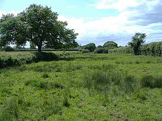
Hunsdon Mead is a 34 hectare biological Site of Special Scientific Interest (SSSI) west of Harlow in Essex. The site is partly in Essex and partly in Hertfordshire, and it is jointly owned and managed by the Essex Wildlife Trust and the Herts and Middlesex Wildlife Trust. The SSSI also includes part of the neighbouring Roydon Mead. The planning authorities are East Hertfordshire District Council and Epping Forest District Council. Hunsdon Mead is registered common land.

Crouch and Roach Estuaries

The Crouch and Roach Estuaries are a 1729 hectare biological Site of Special Scientific Interest (SSSI) at the mouth of the Crouch and Roach rivers in Essex. The Crouch part of the SSSI stretches from near Battlesbridge to Foulness Island, and the Roach from Rochford to the junction with the Crouch. Part of the site is in the Mid-Essex Coast Special Protection Area under the EC Directive on the Conservation of Wild Birds, and a Ramsar wetland site of international importance. It is also part of the Essex Estuaries Special Area of Conservation. An area of 65 hectares is managed by the Essex Wildlife Trust as the Lion Creek and Lower Raypits nature reserve and 8 hectares at Woodham Fen, both of which are managed by the Essex Wildlife Trust. A small area is also a geological SSSI, The Cliff, Burnham-on-Crouch.

Foulness SSSI

Foulness SSSI is a 10,702 hectare biological Site of Special Scientific Interest covering the shoreline between Southend-on-Sea and the Crouch estuary in Essex. It is a key site in A Nature Conservation Review, and is part of the Essex Estuaries Special Area of Conservation. It covers two Ramsar wetland sites of international importance, 'Crouch and Roach Estuaries' and 'Foulness'. An area of 6.4 hectares is Shoeburyness Old Ranges, a Local Nature Reserve managed by the Essex Wildlife Trust.

Long Herdon Meadow

Long Herdon Meadow is a 4.5 hectare biological Site of Special Scientific Interest south of Marsh Gibbon in Buckinghamshire. It is part of Upper Ray Meadows nature reserve, which is managed by the Berkshire, Buckinghamshire and Oxfordshire Wildlife Trust.

West Wood, Little Sampford Essex Wildlife Trust Nature reserve

West Wood is a 23.6 hectare biological Site of Special Scientific Interest in Little Sampford, north of Thaxted in northwestern Essex. It is owned and managed by the Essex Wildlife Trust.

Blue House Farm Essex Wildlife Trust Nature reserve

Blue House Farm is a 242.8 hectare nature reserve and farm in North Fambridge, on the north bank of the River Crouch between Burnham-on-Crouch and South Woodham Ferrers in Essex. It is managed by the Essex Wildlife Trust. Most of the site is in of the Crouch and Roach Estuaries Site of Special Scientific Interest.

Thrift Wood Essex Wildlife Trust Nature reserve

Thrift Wood is a 19.4 hectare biological Site of Special Scientific Interest south-east of Bicknacre in Essex. It is managed by the Essex Wildlife Trust.

Shoeburyness Old Ranges

Shoeburyness Old Ranges or Shoebury Ranges is a 6.4 hectare Local Nature Reserve in Shoeburyness in Essex. It is part of the Foulness Site of Special Scientific Interest, and of the Gunners Park and Shoebury Ranges nature reserve, which is managed by the Essex Wildlife Trust.

Marden Meadows

Marden Meadows is a 3.7-hectare (9.1-acre) biological Site of Special Scientific Interest east of Marden in Kent. Part of the site is in the 5.6-hectare (14-acre) Marden Meadow nature reserve, which is owned and managed by Kent Wildlife Trust.

References

  1. 1 2 "Roding Valley Meadows citation". Sites of Special Scientific Interest. Natural England. Retrieved 6 August 2016.
  2. "Map of Roding Valley Meadows" (PDF). Sites of Special Scientific Interest. Natural England. Retrieved 6 August 2016.
  3. "Roding Valley Meadows". Local Nature Reserves. Natural England. 16 March 2016. Retrieved 6 August 2016.
  4. "Map of Roding Valley Meadows". Local Nature Reserves. Natural England. Retrieved 6 August 2016.
  5. "Roding Valley Meadows". Essex Wildlife Trust. Retrieved 6 August 2016.

Coordinates: 51°37′42″N0°03′53″E / 51.6284°N 0.0646°E / 51.6284; 0.0646

Geographic coordinate system Coordinate system

A geographic coordinate system is a coordinate system that enables every location on Earth to be specified by a set of numbers, letters or symbols. The coordinates are often chosen such that one of the numbers represents a vertical position and two or three of the numbers represent a horizontal position; alternatively, a geographic position may be expressed in a combined three-dimensional Cartesian vector. A common choice of coordinates is latitude, longitude and elevation. To specify a location on a plane requires a map projection.