
Crowborough is a town and civil parish in the Wealden district of East Sussex, England. It is situated in the Weald, at the edge of Ashdown Forest, in the High Weald Area of Outstanding National Beauty. It is 7 miles (11 km) south-west of Royal Tunbridge Wells and 35 miles (56 km) south of London. It has road and rail links and is served by a town council. It is the most populous inland village in East Sussex, with over 20,000 people.

Upper Bacombe and Lower Bacombe are two hamlets in the parish of Wendover, in Buckinghamshire, England. They are located to the south east of the main town, on and at the foot of Bacombe Hill, which is a Local Nature Reserve, and part of the Bacombe and Coombe Hills Site of Special Scientific Interest.

The River Wandle is the largest river of the south southwest sector of London, England. Its name is thought to derive from the community around its mouth, Wandsworth. About 9 miles (14 km) long, it passes through the London Boroughs of Croydon, Sutton, Merton, and Wandsworth to join the River Thames on the Tideway. Much of the river is accessible on the Wandle Trail. A short headwater - the Caterham Bourne - is in Surrey, the historic county of the river's catchment.

The Essex Wildlife Trust (EWT) is one of 47 wildlife trusts which cover the United Kingdom. The EWT was founded in 1959, and it describes itself as Essex's leading conservation charity, which aims to protect wildlife for the future and the people of the county. As of January 2017, it has over 34,000 members and runs 87 nature reserves, 2 nature parks and 11 visitor centres.

Oxleas Wood is one of the few remaining areas of ancient deciduous forest in Eltham in the Royal Borough of Greenwich, in southeast London. Some parts date back over 8,000 years to the end of the last Ice Age, the Younger Dryas. It is part of a larger continuous area of woodland and parkland on the south side of Shooter's Hill: other parts are Jack Wood, Castle Wood, Oxleas Meadows, Falconwood Field, Eltham Common and Eltham Park North. Eltham Park North includes the ancient Shepherdleas Wood. It is also home to Severndroog Castle.

Streatham Common is a large open space on the southern edge of Streatham in the London Borough of Lambeth. The shallow sloping lower (western) half of the common is mostly mowed grass, and the upper (eastern) half is mostly woodland with some small areas of gorse scrub and acid grassland. The eastern half has been designated a Local Nature Reserve.

Hornchurch Country Park is a 104.5-hectare park on the former site of Hornchurch Airfield, south of Hornchurch in the London Borough of Havering, east London.

The Sussex Wildlife Trust (SWT) is a conservation charity covering the historic county of Sussex. It was founded in 1961 and is one of 46 wildlife trusts across the UK and the Isle of Man and Alderney. It is a registered charity and its headquarters at Woods Mill, south of Henfield is also is a nature reserve with a lake, woodland and meadows.

Clifton Without is a suburb and civil parish in the unitary authority of the City of York, North Yorkshire, England. It consists of those parts of Clifton that lie outside, i.e. Without, the (pre-1996) city boundaries and Clifton Moor. It lies on the A19 about two miles north-west of central York.

Elham is a village and civil parish in East Kent situated approximately 9 miles (14 km) south of Canterbury and 5 miles (8 km) north east of Folkestone in the Elham Valley. At the 2011 Census the population included the hamlet of Ottinge and village of Wingmore.

Batchworth was once a hamlet and is now a civil parish and part of Rickmansworth in Hertfordshire. Batchworth Parish Council was created in 2017 consisting of two Three Rivers District Council wards, namely, Rickmansworth Town and Moor Park & Eastbury. The first election was on 4 May 2017. There are eight councillors; four in each ward.

Highfield Country Park is a 70-acre (280,000 m2) area of open land, situated on the east side of Levenshulme, Manchester, that stretches to the east of Broom Avenue across to the rear of Reddish Golf Course and to the junction of Longford Road, Reddish and Nelstrop Road, Levenshulme.

Wheathampstead Local Nature Reserve is a 5.9 hectare Local Nature Reserve (LNR) in Wheathampstead in Hertfordshire. It was declared an LNR by St Albans City Council in 2002, and is leased by Wheathampstead Parish Council from Hertfordshire County Council.
Church Lane Flood Meadow is a 3.3 hectare Local Nature Reserve in North Weald Bassett in Essex. It is owned and managed by Epping Forest District Council.
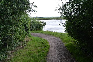
Kendal Park or Hullbridge Foreshore is a 2.8 hectare Local Nature Reserve in Hullbridge in Essex. It is owned by Rochford District Council and managed by Hullbridge Parish Council.
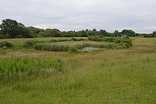
Tiptree Heath Nature Reserve is a 25 hectare biological Site of Special Scientific Interest south-west of Tiptree in Essex, England. It is managed by the Essex Wildlife Trust together with the Friends of Tiptree Heath.

Magnolia Fields or Magnolia Park is a 9.7 hectare Local Nature Reserve in Hawkwell in Essex. It is owned by Rochford District Council and managed by Hawkwell Parish Council.

Clapton is a district in the London Borough of Hackney, in northeast London, England. Subdivisions of Clapton are Lower Clapton and Upper Clapton. Clapton lies 5.6 miles from Charing Cross.


