
Linder's Field is a 3.6 hectare Local Nature Reserve in Buckhurst Hill in Essex. It is owned and managed by Epping Forest District Council.

Roding Valley Meadows is an 18.9-hectare (47-acre) biological Site of Special Scientific Interest in Buckhurst Hill in Essex. It is part of a 65.2 hectare Local Nature Reserve with the same name, which is owned by Epping Forest District Council and Grange Farm Trust, and managed by the Essex Wildlife Trust.

Sir Joseph Hood Memorial Wood is a 1.7 hectare Local Nature Reserve and a Site of Borough Importance for Nature Conservation, Grade I, in Motspur Park in the London Borough of Merton. It adjoins Sir Joseph Hood Memorial Playing Fields, and both are owned and managed by Merton Council.

Gosfield Sandpits is an 8.3 hectare Local Nature Reserve in Gosfield, north of Braintree in Essex. It is owned by Gosfield Parish Council, and managed by the Parish Council and Braintree District Council.

Mill Meadows, Billericay is a 6.7-hectare (17-acre) biological Site of Special Scientific Interest (SSSI) in Billericay in Essex, England. It is part of the 36.8 hectare Mill Meadows Local Nature Reserve (LNR), which is owned and managed by Basildon District Council.
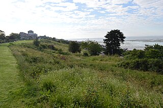
Belton Hills is a 22 hectare Local Nature Reserve in Leigh-on-Sea in Essex. It is owned and managed by Southend-on-Sea City Council.
Tiptree Parish Field is a 2.2 hectare Local Nature Reserve in Tiptree in Essex, England. It is owned and managed by Tiptree Parish Council.
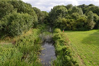
Chelmer Valley Riverside is a 17.6 hectare Local Nature Reserve along the banks of the River Chelmer in Chelmsford in Essex. It is owned and managed by Chelmsford City Council.

Harlow Woods is a 47.1-hectare (116-acre) biological Site of Special Scientific Interest in Harlow in Essex. It is composed of three woods, Hospital Wood Risden's Wood and Parndon Wood. They are owned and maintained by Harlow District Council, and they are part of the slightly larger Parndon Woods and Common Local Nature Reserve.

Hockley Woods is a large woodland in south-east Essex. It is a Local Nature Reserve, and parts are a Site of Special Scientific Interest. It is owned and managed by Rochford District Council.

Colne Local Nature Reserve is a 34.7 hectare Local Nature Reserve in Wivenhoe in Essex. It is owned and managed by Colchester Borough Council.
Colne Valley is a 5.1 hectare Local Nature Reserve north and east of Earls Colne in Essex. It is owned and managed by Colchester Borough Council.

Galleywood Common is a 44.6 hectare Local Nature Reserve in Chelmsford in Essex, near the village of Galleywood. It is owned and managed by Chelmsford City Council.

Grove House Wood is a 2.2 hectare Local Nature Reserve in Stanford-le-Hope in Essex. According to Natural England, it is owned by Thurrock Council and managed by Essex Wildlife Trust but it is not listed on the web site of either body.

Hilly Fields is a 37.5 hectare Local Nature Reserve in Colchester, Essex. It is owned and managed by Colchester Borough Council. It is also a scheduled monument as it is in a late Iron Age site and Roman Camulodunum.

Linford Wood is a 3.5-hectare (8.6-acre) Local Nature Reserve in East Tilbury in Essex. It is owned and managed by Thurrock Council.

Bradlaugh Fields is a 60-hectare (150-acre) open space in Northampton. The site is a former golf course. In 1987 it was proposed to build housing on the site, but after a campaign by local residents it was acquired by Northampton Borough Council and opened as a wildlife park in 1998. It was named after Charles Bradlaugh, a leading nineteenth century radical and atheist who was MP for Northampton. Three fields with a total area of 17.5 hectares are managed by the Wildlife Trust for Bedfordshire, Cambridgeshire and Northamptonshire as a nature reserve also called Bradlaugh Fields. Hills and Holes is at the southern end and two adjoining meadows, Scrub Field and Quarry Field, are at the northern end. Hills and Holes is an 8.3 hectare Local Nature Reserve (LNR) and Scrub Field is a 5.1-hectare (13-acre) LNR.

Foxburrow Wood is a 6.1-hectare (15-acre) Local Nature Reserve in Rainham in Kent. It is owned and managed by Medway Council.

