
The City of Chelmsford is a local government district with borough and city status in Essex, England. It is named after its main settlement, Chelmsford, which is also the county town of Essex. As well as the settlement of Chelmsford itself, the district also includes the surrounding rural area and the town of South Woodham Ferrers.

The River Blackwater is a river in Essex, England. It rises as the River Pant in the northwest of the county, just east of Saffron Walden, and flows in a generally southeast direction to Bocking, near Braintree, via Great Sampford and Great Bardfield. At Bocking, it becomes the River Blackwater, and veers east to flow past Bradwell Juxta Coggeshall and Coggeshall. It then veers south, flowing past Kelvedon and Witham, before reaching Maldon. There, it veers east again and empties into the Blackwater Estuary, which in turn meets the North Sea at Mersea Island.

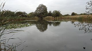
Ingrebourne Valley is a local nature reserve (LNR) in Hornchurch in the London Borough of Havering. It is owned and managed by Havering Council, and has a visitor centre managed by the Essex Wildlife Trust. Most of it is in Hornchurch Country Park west of the River Ingrebourne, but there are also areas north and south of the park which are part of the LNR. It has a wide range of habitats, including woodland, grassland, the river and marshes. It is an important site for a range of species of plants, animals and birds, including great crested newts, slow worms, the harvest mouse and the water vole.

Ingrebourne Marshes are a 74.8 hectare biological Site of Special Scientific Interest in Hornchurch in the London Borough of Havering. Ingrebourne Valley Local Nature Reserve includes a small part of the SSSI west of the River Ingrebourne. The site is managed by the Essex Wildlife Trust

The Riddy is an 8.4 hectare flood meadow and Local Nature Reserve located in Sandy, Bedfordshire, United Kingdom, bordering the River Ivel. Owned by Sandy Town Council but managed by both the Wildlife Trust for Bedfordshire, Cambridgeshire and Northamptonshire and Bedfordshire Rural Communities Charity, the 7.7 hectares site gains its name from a small stream which flows through the eastern end of the reserve. The different habitats in the Riddy support a diverse range of species, including a multiplicity of grasses and flowering plants in the meadows, aquatic plants and water voles which inhabit the ditches, ponds and stream, and birds which feed and hunt across the reserve.
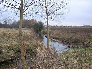
The River Can is a river in Essex, England. Chelmsford is centred on the confluence of the Can and the River Chelmer. The Can enters Chelmsford from the west, joining the Chelmer to the east of the city. From the confluence, the Can becomes part of the Chelmer and Blackwater Navigation. The River Wid also meets the Can in the same area.

Little Waltham is a village and civil parish just north of Chelmsford, in Essex, England. It is adjacent to the village of Great Waltham. The Domesday Book refers to the two villages as Waltham, consisting of several manors. The site of an Iron Age village was excavated before upgrading the main road north between the current villages.

Frays Farm Meadows is a 28.2-hectare (70-acre) biological Site of Special Scientific Interest near Denham in the London Borough of Hillingdon. It was notified as an SSSI in 1981, and has been managed by the London Wildlife Trust on behalf of Hillingdon Council since 1999. It is part of the Colne Valley Regional Park.

Roding Valley Meadows is an 18.9-hectare (47-acre) biological Site of Special Scientific Interest in Buckhurst Hill in Essex. It is part of a 65.2 hectare Local Nature Reserve with the same name, which is owned by Epping Forest District Council and Grange Farm Trust, and managed by the Essex Wildlife Trust.
The Chase is a nature reserve in Dagenham in London. Most of it is in the London Borough of Barking and Dagenham, with a small part in Havering. It is owned by the boroughs, and managed by London Borough of Barking & Dagenham - Parks & Countryside Ranger Service. The boroughs have designated the sections in their respective boroughs as Local Nature Reserves. The Chase, together with the neighbouring Eastbrookend Country Park, is also designated a Site of Metropolitan Importance for Nature Conservation.
Ravensbury Park is a public park in Mitcham in the London Borough of Merton. An area of 7 hectares is designated a Local Nature Reserve. The River Wandle runs along the southern boundary of the park, which is also part of the Upper Wandle River Site of Metropolitan Importance for Nature Conservation.

Watercress Wildlife Site is a 1.2-hectare (3.0-acre) Local Nature Reserve in St Albans, Hertfordshire, England. It is owned by St Albans City Council and managed by the Watercress Wildlife Association, a registered charity. The boundaries of the site are the Alban Way, the River Ver and the houses of Riverside Road.

Weald Common Flood Meadows is a 1.9 hectare Local Nature Reserve in North Weald Bassett in Essex. It is owned and managed by Epping Forest District Council.

Brockwell Meadows is a 4.3 hectare Local Nature Reserve in Kelvedon in Essex. It is owned by Kelevdon Parish Council and managed by the Council together with a group of local residents called the Brockwell Group.

Colne Local Nature Reserve is a 34.7 hectare Local Nature Reserve in Wivenhoe in Essex. It is owned and managed by Colchester Borough Council.

Galleywood Common is a 44.6 hectare Local Nature Reserve in Chelmsford in Essex, near the village of Galleywood. It is owned and managed by Chelmsford City Council.
Newland Grove is a 3.2-hectare (7.9-acre) nature reserve north of Chelmsford in Essex. It is managed by the Essex Wildlife Trust.

Riverside Walk is a 21.2-hectare (52-acre) local nature reserve in Virginia Water, Surrey. It is owned by Runnymede Borough Council and managed by The Cabrera Trust Committee.

Liss Riverside Railway Walk South is a 1.6-hectare (4.0-acre) Local Nature Reserve in Liss in Hampshire. It is owned and managed by Liss Parish Council.

