
The Essex Wildlife Trust (EWT) is one of 46 wildlife trusts which cover the United Kingdom. The EWT was founded in 1959, and it describes itself as Essex's leading conservation charity, which aims to protect wildlife for the future and the people of the county. As of January 2017, it has over 34,000 members and runs 87 nature reserves, 2 nature parks and 11 visitor centres.

Colne Estuary is a 2915 hectare biological and geological Site of Special Scientific Interest near Brightlingsea in Essex. It is also a Nature Conservation Review site, a National Nature Reserve, a Ramsar wetland site of international importance, a Special Protection Area, a Special Area of Conservation, and a Geological Conservation Review site. Three areas in the site are managed by the Essex Wildlife Trust, Colne Point, Fingringhoe Wick and Howlands Marsh.

Ingrebourne Marshes are a 74.8 hectare biological Site of Special Scientific Interest in Hornchurch in the London Borough of Havering. Ingrebourne Valley Local Nature Reserve includes a small part of the SSSI west of the River Ingrebourne. The site is managed by the Essex Wildlife Trust

Frays Farm Meadows is a 28.2-hectare (70-acre) biological Site of Special Scientific Interest near Denham in the London Borough of Hillingdon. It was notified as an SSSI in 1981, and has been managed by the London Wildlife Trust on behalf of Hillingdon Council since 1999. It is part of the Colne Valley Regional Park.
Benfleet and Southend Marshes is an 8.1-square-mile (21 km2) Site of Special Scientific Interest (SSSI) in Essex. It consists of mudflats, salt marshes, scrub and wild grassland, and includes the Southend-on-Sea foreshore. It has been so recognised for its biological value, rather than geological. A definition five percent larger forms the Benfleet and Southend Marshes Ramsar site and Special Protection Area. In the centre-west, more than ten percent of the Site is the Leigh National Nature Reserve (NNR), which has been appraised in detail in A Nature Conservation Review as a site of national importance. The SSSI and NNR include the eastern half of Two Tree Island, in Leigh on Sea which is managed by the Essex Wildlife Trust. A narrow majority of the Site is the Southend on Sea Foreshore Local Nature Reserve.

The Crouch and Roach Estuaries are a 1729 hectare biological Site of Special Scientific Interest (SSSI) at the mouth of the Crouch and Roach rivers in Essex. The Crouch part of the SSSI stretches from near Battlesbridge to Foulness Island, and the Roach from Rochford to the junction with the Crouch. Part of the site is in the Mid-Essex Coast Special Protection Area under the EC Directive on the Conservation of Wild Birds, and a Ramsar wetland site of international importance. It is also part of the Essex Estuaries Special Area of Conservation. An area of 65 hectares is managed by the Essex Wildlife Trust as the Lion Creek and Lower Raypits nature reserve and 8 hectares at Woodham Fen, both of which are managed by the Essex Wildlife Trust. A small area is also a geological SSSI, The Cliff, Burnham-on-Crouch.

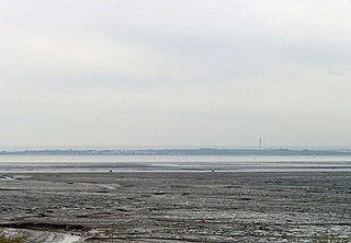
Mucking Flats and Marshes is a 311.6 biological Site of Special Scientific Interest east of Tilbury in Essex. It is part of the Thames Estuary and Marshes Ramsar site. and Special Protection Area

Pitsea Marsh is a 94.6 hectare Site of Special Scientific Interest in Pitsea in Essex. The southern half is the Wat Tyler Country Park, and the northern half is private land.

Holland Haven Marshes is a 208.8-hectare (516-acre) biological Site of Special Scientific Interest north-east of Clacton-on-Sea in Essex. It is an L shaped site which stretches along the coast from Frinton-on-Sea to Holland-on-Sea, and then north along the Holland Brook. It includes Holland Haven Country Park, a 22.1 hectare Local Nature Reserve owned and managed by Tendring District Council.
Sandbeach Meadows are a 30.3-hectare (75-acre) biological Site of Special Scientific Interest on the Dengie Peninsula, south-east of Bradwell-on-Sea in Essex. The local planning authority is Maldon District Council.

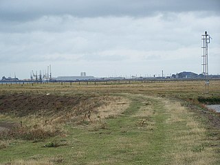
Vange and Fobbing Marshes are a 164.6-hectare (407-acre) biological Site of Special Scientific Interest in two areas south of Basildon in Essex. Vange Marsh is managed by the Royal Society for the Protection of Birds.

West Thurrock Lagoon and Marshes is a 66.1-hectare (163-acre) biological Site of Special Scientific Interest in West Thurrock in Essex.

Howlands Marsh is a 29.9-hectare (74-acre) nature reserve north-east of St Osyth in Essex. It is managed by the Essex Wildlife Trust. It is part of the Colne Estuary Site of Special Scientific Interest Special Protection Area and Ramsar site, and the Blackwater Flats and Marshes Nature Conservation Review site.

Lion Creek and Lower Raypits is a 65.2 hectare nature reserve east of Canewdon in Essex. It is part of the Crouch and Roach Estuaries Site of Special Scientific Interest, and is owned and managed by the Essex Wildlife Trust.

Bugg's Hole Fen is a 3.7-hectare (9.1-acre) biological Site of Special Scientific Interest north-west of Thelnetham in Suffolk.

Lockington Marshes is an 11.3-hectare (28-acre) biological Site of Special Scientific Interest north of Ratcliffe on Soar in Leicestershire.
Medway Estuary and Marshes is a 4,748.8-hectare (11,735-acre) biological Site of Special Scientific Interest which stretches along the banks of the River Medway between Gillingham and Sheerness in Kent. It is a Nature Conservation Review site, Grade I, a Ramsar internationally important wetland site, and a Special Protection Area under the European Union Directive on the Conservation of Wild Birds.

South Thames Estuary and Marshes is a 5,289-hectare (13,070-acre) biological Site of Special Scientific Interest which stretches between Gravesend and the mouth of the River Medway in Kent. Part of it is a Nature Conservation Review site, Grade I, and part is a Royal Society for the Protection of Birds nature reserve. It is part of the Thames Estuary and Marshes Ramsar internationally important wetland site and Special Protection Area under the European Union Directive on the Conservation of Wild Birds.
